2024-05-08 34 -118
| Wed 8 May 2024 in 34,-118: 34.4130363, -118.5996918 geohashing.info google osm bing/os kml crox |
Location
The hash is in a dirt area off the road near Magic Mountain. Google's Street View from 6 months ago shows some piles of dirt and a freestanding gate we can walk past. Behind the hash is a ditch with a dry culvert that we could also walk down. (Apple's satellite imagery is quite old, showing actual construction that no longer appears to be there.)
Participants
Plans
This morning, I (Jeremy) got a notification from my geohash-calculating shortcut that the geohash was accessible. We (me and Ethan) have been waiting for months for our first hash, so this is really exciting. Today happens to be a really good day, our schedules are clear and the weather is great. There are four geocaches nearby and the Iron Horse Trailhead is close, so we will try to take our bikes down to the trailhead and bike around.
Expedition
Tracklog
Photos

We have arrived at the Iron Horse Trailhead! This is great! @34.4244,-118.5764

We made it! Woohoo! @34.4130,-118.5997
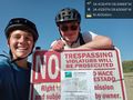
"It isn't trespassing if you don't get caught" - Jeremy @34.4129,-118.6007


Achievements
Jeremy and Ethan earned the Land geohash achievement
|