Difference between revisions of "2024-05-13 43 -124"
Michael5000 (talk | contribs) |
m (subst-ing) |
||
| (One intermediate revision by the same user not shown) | |||
| Line 8: | Line 8: | ||
And DON'T FORGET to add your expedition and the best photo you took to the gallery on the Main Page! We'd love to read your report, but that means we first have to discover it! :) | And DON'T FORGET to add your expedition and the best photo you took to the gallery on the Main Page! We'd love to read your report, but that means we first have to discover it! :) | ||
-->{{meetup graticule | -->{{meetup graticule | ||
| − | | lat= | + | | lat=43 |
| − | | lon= | + | | lon=-124 |
| − | | date= | + | | date=2024-05-13 |
}}<!-- edit as necessary --> | }}<!-- edit as necessary --> | ||
== Location == | == Location == | ||
| Line 44: | Line 44: | ||
[[Category:Expeditions with photos]] | [[Category:Expeditions with photos]] | ||
[[Category:Coordinates reached]] | [[Category:Coordinates reached]] | ||
| + | {{location|US|OR|CO}} | ||
Latest revision as of 21:20, 24 May 2024
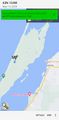
| Mon 13 May 2024 in 43,-124: 43.3948827, -124.3071556 geohashing.info google osm bing/os kml crox |
Location
On the North Spit of Coos Bay.
Participants
Expedition
Having conducted some business in North Bend, I drove over the McCullough Bridge and then out across the causeway that leads to the North Spit area. On the map, it looked like a road would lead to within a hop, skip, and jump of the hashpoint, but I didn't really do my homework on that point -- that "road" is really just part of a network of dune trails, I think.
I parked at the end of Trans-Pacific Lane, about 1.7 kilometers from the hashpoint, and started into the trail network. I wanted to go pretty much straight west, though, and all of the trails wanted to go south by southwest, and I had a hard time making much progress. Finally, I decided to try for a straight shot through the forest, but that wasn't as easy as it look and I soon got pretty disoriented. At this point I had been walking for quite a while, so when I found the trail again, I decided to call it a day.
Then, naturally, I found a side trail I had missed before, and it turned out that, after another kilometer or so of walking, it got me to within a hop, skip, and jump of the hashpoint. And there I was!
Photos
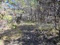
View from the hashpoint
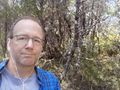
Me at the hashpoint
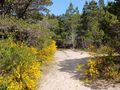
Along the trail
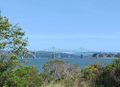
The bridge!


Achievements
- First expedition to Coos County and the Coos Bay graticule since 2010.