Difference between revisions of "2012-04-01 19 -155"
imported>Simonradford (Created page with "<!-- If you did not specify these parameters in the template, please substitute appropriate values for IMAGE, LAT, LON, and DATE (YYYY-MM-DD format) [[Image:{{{image|IMAGE}}}|t...") |
imported>Simonradford (→Photos) |
||
| Line 41: | Line 41: | ||
<gallery perrow="5"> | <gallery perrow="5"> | ||
Image:2012-04_01_19_-155-a.jpg | Jeep track through the forest. | Image:2012-04_01_19_-155-a.jpg | Jeep track through the forest. | ||
| − | Image:2012- | + | Image:2012-04_01_19_-155-b.jpg | Wet, impenetrable forest. |
| − | Image:2012- | + | Image:2012-04_01_19_-155-c.jpg | You can (just) read the GPS coordinated. |
| − | Image:2012- | + | Image:2012-04_01_19_-155-d.jpg | I have arrived. |
</gallery> | </gallery> | ||
Revision as of 07:39, 4 April 2012
| Sun 1 Apr 2012 in 19,-155: 19.6803372, -155.2810392 geohashing.info google osm bing/os kml crox |
Location
In a (wet and impenetrable) forest in the Saddle between Mauna Loa and Mauna Kea. A mile or so from the highway just off a jeep track.
Participants
Plans
No plans. Spontaneity rules.
Expedition
Drove up the Saddle road through the usual east Hawaii drizzle. A nice turnout from the highway led to a jeep track leading off through a (wet) forest growing over an old a'a field. Lots of bird calls. Followed the the track until the GPS showed I was only 40 yards away. Tried bushwhacking to get a bit closer but gave up after only 10 yards or so. The waist high brush obscured the underlying lava boulders, making footing treacherous. And did I say wet? The GPS showed I was there, if you round off to 1 arcsec.
Tracklog
Photos
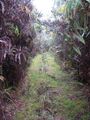
Jeep track through the forest.
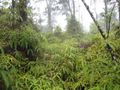
Wet, impenetrable forest.
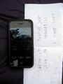
You can (just) read the GPS coordinated.

I have arrived.


Achievements
Simon earned the Land geohash achievement
|