2024-05-09 47 -122
| Thu 9 May 2024 in 47,-122: 47.5054684, -122.3886777 geohashing.info google osm bing/os kml crox |
Location
Arroyo Beach Place, downhill from the Arbor Heights neighborhood of West Seattle.
Participants
Plans
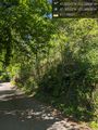
Is it directly on the road? Satellite imagery is inconclusive due to tree cover; Google's map thinks so, but Street View shows the marker up a steep hillside into parks department land.
Bike? Last Sunday I passed about a mile away on the Emerald City Ride, so I know it's both far and hilly.
Transit? A one-way loop through Arbor Heights is served by route 22 every... uh... 70ish minutes, as well as by a few commute-oriented express trips of route 21. Since it's only a 15 minute walk to the point, 70 minutes seems like a long time to spend. Route 22 connects to the Westwood Village shopping mall, a significant bus hub also served by the H Line, the newest RapidRide route.
Expedition
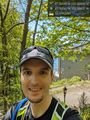
- On board an H Line bus, fastest among 3 simultaneous departures to Westwood Village, to connect with infrequent route 22. -- Coyotebush (talk) @47.6047,-122.3333 13:41, 9 May 2024 (PDT)
Tracklog
Walk, bus to hash to bus:
Photos
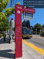
Route 22 @47.5211,-122.3651
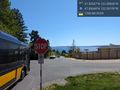
Goodbye bus @47.5065,-122.3816
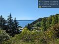
Roadside overlook @47.5038,-122.3823
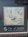
Park map not actually at "you are here" @47.5042,-122.3853
Heading north @47.5030,-122.3859
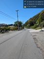
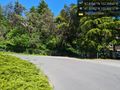
End of pavement @47.5044,-122.3878
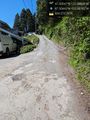
Hillside @47.5056,-122.3889
Grin up the hill @47.5056,-122.3888
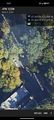
Best GPS screenshot

Panorama from the road
Google Maps thinks you can teleport through this to a bus stop @47.5026,-122.3821
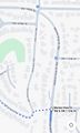
Bus stops map


Achievements