2024-05-18 44 -124
| Sat 18 May 2024 in 44,-124: 44.1728929, -124.0998813 geohashing.info google osm bing/os kml crox |
Location
On a ridge north of Big Creek Road, near Heceta Head.
Participants
Expedition
This hashpoint was only a few kilometers from Heceta Head, a landmark seen in a million generic calendar photos, so of course I took a picture for you.

A few minutes north, there's an attractive bridge over the imaginatively named "Big Creek." Immediately afterwards, I turned off Highway 101 on Big Creek Road, and drove in about a kilometer.
I was afraid that the 200 meters between the road and the hashpoint would be prohibitively steep and/or impenetrable, but although it was as steep as a staircase, it was quite open and easy to climb. It was surprisingly easy to get up on the ridge, after which it was a short walk to ground zero.
Sometimes getting down is harder than climbing up, but that was actually pretty easy too, this time. I went back to the highway and continued my journey north.
Photos
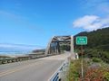
The bridge at Big Creek
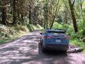
Big Creek Road
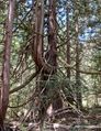
The hashpoint tree

Me


Achievements
- My first expedition to the elusive Lincoln City graticule!