Difference between revisions of "2024-05-09 47 -122"
Coyotebush (talk | contribs) ([live picture]Route 22 [https://openstreetmap.org/?mlat=47.52111389&mlon=-122.36506389&zoom=16 @47.5211,-122.3651]) |
m (Location) |
||
| (15 intermediate revisions by one other user not shown) | |||
| Line 11: | Line 11: | ||
| lon=-122 | | lon=-122 | ||
| date=2024-05-09 | | date=2024-05-09 | ||
| + | | graticule_name=Seattle | ||
| + | | graticule_link=Seattle, Washington | ||
}}<!-- edit as necessary --> | }}<!-- edit as necessary --> | ||
== Location == | == Location == | ||
<!-- where you've surveyed the hash to be --> | <!-- where you've surveyed the hash to be --> | ||
| + | Arroyo Beach Place, downhill from the Arbor Heights neighborhood of West Seattle. | ||
== Participants == | == Participants == | ||
<!-- who attended: If you link to your wiki user name in this section, your expedition will be picked up by the various statistics generated for geohashing. You may use three tildes ~ as a shortcut to automatically insert the user signature of the account you are editing with. | <!-- who attended: If you link to your wiki user name in this section, your expedition will be picked up by the various statistics generated for geohashing. You may use three tildes ~ as a shortcut to automatically insert the user signature of the account you are editing with. | ||
--> | --> | ||
| + | |||
| + | * [[User:coyotebush|coyotebush]] | ||
== Plans == | == Plans == | ||
<!-- what were the original plans --> | <!-- what were the original plans --> | ||
| + | |||
| + | Is it directly on the road? Satellite imagery is inconclusive due to tree cover; Google's map thinks so, but Street View shows the marker up a steep hillside into parks department land. | ||
| + | |||
| + | Bike? Last Sunday I [https://ridewithgps.com/routes/46492681 passed about a mile away] on the Emerald City Ride, so I know it's both far and hilly. | ||
| + | |||
| + | Transit? A one-way loop through Arbor Heights is served by route 22 every... uh... 70ish minutes, as well as by a few commute-oriented express trips of route 21. Since it's only a 15 minute walk to the point, 70 minutes seems like a long time to spend. Route 22 connects to the Westwood Village shopping mall, a significant bus hub also served by the H Line, the newest RapidRide route. So a three-seat ride each way, or a couple miles extra walking to Westwood Village or Fauntleroy. | ||
| + | |||
| + | Lunch to break up the trip? Looks like Westwood Village mostly has chain fast food. | ||
== Expedition == | == Expedition == | ||
<!-- how it all turned out. your narrative goes here. --> | <!-- how it all turned out. your narrative goes here. --> | ||
| + | Sunny day, heading for a hot weekend. Had no plans until evening, but while researching the above info in the morning I wasn't confident I wanted to make the trip. After some lunch I checked directions again, noticed that leaving soon would line up well with the 22 schedule, and decided to head out. | ||
| + | |||
| + | Light rail to downtown, ending up able to catch an earlier H Line trip than expected. That one actually showed up 6 minutes late, simultaneously with buses on route 125 and route 21, all displaying Westwood Village. | ||
*On board an H Line bus, fastest among 3 simultaneous departures to Westwood Village, to connect with infrequent route 22. -- [[User:Coyotebush|Coyotebush]] ([[User talk:Coyotebush|talk]]) [https://openstreetmap.org/?mlat=47.60467155&mlon=-122.33325985&zoom=16 @47.6047,-122.3333] 13:41, 9 May 2024 (PDT) | *On board an H Line bus, fastest among 3 simultaneous departures to Westwood Village, to connect with infrequent route 22. -- [[User:Coyotebush|Coyotebush]] ([[User talk:Coyotebush|talk]]) [https://openstreetmap.org/?mlat=47.60467155&mlon=-122.33325985&zoom=16 @47.6047,-122.3333] 13:41, 9 May 2024 (PDT) | ||
| + | |||
| + | Roads familiar from the bike ride, then a twelve minute wait to transfer to the 22, where I was soon the only passenger. Realized I should get off at the top of the road to Arroyo Beach, rather than a few stops later as erroneously suggested, and was greeted with the best view yet of the sound. | ||
| + | |||
| + | I started down the hill and was soon glad I hadn't brought a bike with which I'd have to climb up again. The views, including adjacent cliffs and Vashon Island ferries, were better than anticipated. A few cars and another friendly walker passed me. | ||
| + | |||
| + | Right turn onto Arroyo Beach Place. Fancier homes down here than at the top. A few people out: landscaping, power washing, working in garage. Increasingly private-looking towards the end. | ||
| + | |||
| + | From the road, my phone said the point was at least 15 feet east - up the hillside, fortunately not directly across from any of the homes. I found a reasonable spot to scramble up and gain a few horizontal feet - didn't change typical readings, but did briefly get a 5-foot reading. I'm confident I could have reached any of the relative locations indicated, but didn't care to dance around in the ferns. | ||
| + | |||
| + | Could have explored the other end of the road (which in retrospect appears to have shore access) but was nervous about missing the next bus so ascended again. Back at the top, I still had 25 minutes to spare, so with a bus stop every block I decided to walk along the bus route until it caught up with me. Home by the same route, with more passengers than before as peak commute traffic had clearly started. Four hours in total. | ||
| + | |||
== Tracklog == | == Tracklog == | ||
| − | + | Walk, bus to hash to bus: | |
| + | |||
| + | {{Tracklog|2024-05-09 47 -122 coyotebush walk.gpx}} | ||
== Photos == | == Photos == | ||
| Line 37: | Line 66: | ||
Image:2024-05-09_47_-122_coyotebush_1715289877127.jpg|Route 22 [https://openstreetmap.org/?mlat=47.52111389&mlon=-122.36506389&zoom=16 @47.5211,-122.3651] | Image:2024-05-09_47_-122_coyotebush_1715289877127.jpg|Route 22 [https://openstreetmap.org/?mlat=47.52111389&mlon=-122.36506389&zoom=16 @47.5211,-122.3651] | ||
| + | |||
| + | Image:2024-05-09_47_-122_coyotebush_1715301673802.jpg|Goodbye bus [https://openstreetmap.org/?mlat=47.50648056&mlon=-122.38159167&zoom=16 @47.5065,-122.3816] | ||
| + | |||
| + | Image:2024-05-09_47_-122_coyotebush_1715301727639.jpg|Roadside overlook [https://openstreetmap.org/?mlat=47.50376389&mlon=-122.38229167&zoom=16 @47.5038,-122.3823] | ||
| + | |||
| + | Image:2024-05-09_47_-122_coyotebush_1715301798068.jpg|Park map not actually at "you are here" [https://openstreetmap.org/?mlat=47.50416667&mlon=-122.38530556&zoom=16 @47.5042,-122.3853] | ||
| + | |||
| + | Image:2024-05-09_47_-122_coyotebush_1715301846379.jpg|Heading north [https://openstreetmap.org/?mlat=47.50303333&mlon=-122.38593889&zoom=16 @47.5030,-122.3859] | ||
| + | |||
| + | Image:2024-05-09_47_-122_coyotebush_1715301864719.jpg|End of pavement [https://openstreetmap.org/?mlat=47.50443056&mlon=-122.38781667&zoom=16 @47.5044,-122.3878] | ||
| + | |||
| + | Image:2024-05-09_47_-122_coyotebush_1715301921493.jpg|Hillside [https://openstreetmap.org/?mlat=47.50555000&mlon=-122.38887500&zoom=16 @47.5056,-122.3889] | ||
| + | |||
| + | Image:2024-05-09_47_-122_coyotebush_1715301959162.jpg|Grin up the hill [https://openstreetmap.org/?mlat=47.50560000&mlon=-122.38876389&zoom=16 @47.5056,-122.3888] | ||
| + | |||
| + | Image:2024-05-09_47_-122_coyotebush_1715302045587.jpg|Best GPS screenshot | ||
| + | |||
| + | Image:2024-05-09_47_-122_coyotebush_1715302219636.jpg|Panorama from the road | ||
| + | |||
| + | Image:2024-05-09_47_-122_coyotebush_1715302448754.jpg|Google Maps thinks you can teleport through this to a bus stop [https://openstreetmap.org/?mlat=47.50261944&mlon=-122.38211944&zoom=16 @47.5026,-122.3821] | ||
| + | |||
| + | Image:2024-05-09_47_-122_coyotebush_1715302470033.jpg|Bus stops map | ||
</gallery> | </gallery> | ||
| Line 42: | Line 93: | ||
{{#vardefine:ribbonwidth|100%}} | {{#vardefine:ribbonwidth|100%}} | ||
<!-- Add any achievement ribbons you earned below, or remove this section --> | <!-- Add any achievement ribbons you earned below, or remove this section --> | ||
| + | |||
| + | {{Public transport geohash | latitude = 47 | longitude = -122 | date = 2024-05-09 | name = coyotebush | image = 2024-05-09 47 -122 coyotebush 1715289877127.jpg }} | ||
__NOTOC__ | __NOTOC__ | ||
| − | |||
| − | |||
| − | |||
| − | |||
| − | |||
| − | |||
| − | |||
| − | |||
| − | |||
[[Category:Expeditions]] | [[Category:Expeditions]] | ||
| − | |||
[[Category:Expeditions with photos]] | [[Category:Expeditions with photos]] | ||
| − | |||
| − | |||
| − | |||
| − | |||
[[Category:Coordinates reached]] | [[Category:Coordinates reached]] | ||
| − | + | {{location|US|WA|KN}} | |
| − | |||
| − | |||
| − | |||
| − | |||
| − | |||
| − | |||
| − | |||
| − | |||
| − | |||
| − | |||
| − | |||
| − | |||
| − | |||
Latest revision as of 18:42, 10 May 2024
| Thu 9 May 2024 in Seattle: 47.5054684, -122.3886777 geohashing.info google osm bing/os kml crox |
Location
Arroyo Beach Place, downhill from the Arbor Heights neighborhood of West Seattle.
Participants
Plans
Is it directly on the road? Satellite imagery is inconclusive due to tree cover; Google's map thinks so, but Street View shows the marker up a steep hillside into parks department land.
Bike? Last Sunday I passed about a mile away on the Emerald City Ride, so I know it's both far and hilly.
Transit? A one-way loop through Arbor Heights is served by route 22 every... uh... 70ish minutes, as well as by a few commute-oriented express trips of route 21. Since it's only a 15 minute walk to the point, 70 minutes seems like a long time to spend. Route 22 connects to the Westwood Village shopping mall, a significant bus hub also served by the H Line, the newest RapidRide route. So a three-seat ride each way, or a couple miles extra walking to Westwood Village or Fauntleroy.
Lunch to break up the trip? Looks like Westwood Village mostly has chain fast food.
Expedition
Sunny day, heading for a hot weekend. Had no plans until evening, but while researching the above info in the morning I wasn't confident I wanted to make the trip. After some lunch I checked directions again, noticed that leaving soon would line up well with the 22 schedule, and decided to head out.
Light rail to downtown, ending up able to catch an earlier H Line trip than expected. That one actually showed up 6 minutes late, simultaneously with buses on route 125 and route 21, all displaying Westwood Village.
- On board an H Line bus, fastest among 3 simultaneous departures to Westwood Village, to connect with infrequent route 22. -- Coyotebush (talk) @47.6047,-122.3333 13:41, 9 May 2024 (PDT)
Roads familiar from the bike ride, then a twelve minute wait to transfer to the 22, where I was soon the only passenger. Realized I should get off at the top of the road to Arroyo Beach, rather than a few stops later as erroneously suggested, and was greeted with the best view yet of the sound.
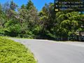
I started down the hill and was soon glad I hadn't brought a bike with which I'd have to climb up again. The views, including adjacent cliffs and Vashon Island ferries, were better than anticipated. A few cars and another friendly walker passed me.
Right turn onto Arroyo Beach Place. Fancier homes down here than at the top. A few people out: landscaping, power washing, working in garage. Increasingly private-looking towards the end.
From the road, my phone said the point was at least 15 feet east - up the hillside, fortunately not directly across from any of the homes. I found a reasonable spot to scramble up and gain a few horizontal feet - didn't change typical readings, but did briefly get a 5-foot reading. I'm confident I could have reached any of the relative locations indicated, but didn't care to dance around in the ferns.
Could have explored the other end of the road (which in retrospect appears to have shore access) but was nervous about missing the next bus so ascended again. Back at the top, I still had 25 minutes to spare, so with a bus stop every block I decided to walk along the bus route until it caught up with me. Home by the same route, with more passengers than before as peak commute traffic had clearly started. Four hours in total.
Tracklog
Walk, bus to hash to bus:
Photos
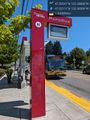
Route 22 @47.5211,-122.3651
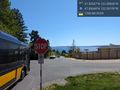
Goodbye bus @47.5065,-122.3816
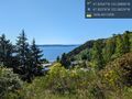
Roadside overlook @47.5038,-122.3823
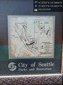
Park map not actually at "you are here" @47.5042,-122.3853
Heading north @47.5030,-122.3859
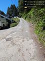
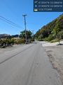
End of pavement @47.5044,-122.3878
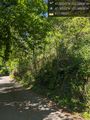
Hillside @47.5056,-122.3889
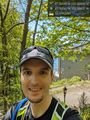
Grin up the hill @47.5056,-122.3888
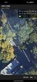
Best GPS screenshot

Panorama from the road
Google Maps thinks you can teleport through this to a bus stop @47.5026,-122.3821
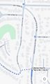
Bus stops map


Achievements
coyotebush earned the Public transport geohash achievement
|