| SastRe.O
|
|
|
|
|
|
|
|
|
|
|
|
|

|
Likes to get there by bike.
|
|
If a game includes a GPS and some coordinates that the Internet told me to reach, you can probably count me in :) (I guess now you know how to kidnap me... :/). I am also active in Geocaching and Waymarking. As random coordinates refers to, besides searching for geohash coordinates, I also specially enjoy hunting for palindromic and irrational coordinates (still constructing the idea of the last one).
I hope to be more active in Graticule 54 13 and 41 2 (My time in graticule 54,13 has ended).
Equipment
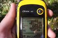
- GPSr eTrex 10. Precise enough for my activities.
- Smartphone, app Locus. That's where I have all the needed offline cartography. And stored geocaches.
Retired equipment
- Winterbuche. Old and unreliable bike, but if you trust it, it won't fail you (until it does). Last expedition: 2020-08-13 54 13
Expeditions
Automated list by AperfectBot below:
 2018-11-04 54 13 - Near Groß Bisdorf (Vorpommern-Rügen, Meck-Pomm), in the edge of a field rea...
- 2018-11-09 54 13 - In a field, near Neu Ungnade, south-west of Greifswald (Mecklenburg-Vorpomm...

- 2018-11-23 54 13 - Next to the shopping centre Elisen Park, in Greifswald. In a field.
- 2018-11-28 54 13 - In the outskirts of Greifswald. Near a field.
- 2018-12-07 54 13 - In a forest next to the Ryckgraben, near Wackerow (MV, Deutschland).
 2018-12-16 54 13 - Bettina-von-Arnim Straße 15, Greifswald.
 - 2019-02-03 54 13 - In a field south-east of Horst (MV, Deutschland)
- 2019-02-27 54 13 - In the Potthäger forest, Weitenhagen, MV, Deutschland.
- 2019-04-21 54 13 - North of Neu Boltenhagen, MV, Deutschland. In the edge of a field.
- 2019-05-18 53 13 - Pommersche Straße 8, Gützkow, MV, Deutschland.
- 2019-06-02 54 13 - Forest area near Griebenow, MV, Germany.
- 2019-06-28 53 13 - In Karlsburg, MV, Germany.
- 2019-07-06 54 13 - South of Neu Boltenhagen, MV, Germany, behind someone's backyard in a field...
- 2019-07-09 54 13 - In a field north of Neuenkirchen, MV, Germany.
- 2019-07-17 54 13 - In between fields south of Rubenow, MV, Germany.
- 2019-07-22 54 13 - Between two fields, between Dersekow and Dargelin, MV, Germany.
- 2019-07-24 54 13 - In the edge of a field near Vierow (Brünzow), MV, Germany.
- 2019-08-03 54 13 - In the forest north of Bremerhagen (Sundhagen), VR, MV, Germany.
- 2019-08-14 53 13 - Karlsburger und Oldenburger Holz, Oldenburg (Züssow), VG, MV, Germany.

- 2019-08-20 54 13 - On water near Wampen (Neuenkirchen), VG, MV, Germany.
- 2019-09-17 41 2 - In a park in Mataró, Maresme, Catalonia.
- 2019-10-09 41 2 - Mediterranean Sea, about 25km of the coast of Pineda de Mar, Catalonia.
- 2019-10-21 54 13 - In a sugar-beet field in Greifswald, MV, Germany.
- 2019-10-23 54 13 - Between two fields in the edge of Dersekow, MV, Germany.
- 2019-11-17 54 13 - In Hanshagen, VG, MV, Germany.
- 2020-02-14 54 13 - In the Wendorfer Forest (Sundhagen), VR, MV, Germany.
- 2020-02-17 54 12 - In the edge of a field in Gransebieth, VR, MV, Germany.
- 2020-02-29 54 13 - Field between Neu Boltenhagen and Lodmannshagen, VG, MV, Germany.
- 2020-03-31 54 13 - In the Potthäger Forest, Weitenhagen, VG, MV, Germany.
- 2020-04-04 54 13 - NSG Eldena, Greifswald, MV, Germany.
- 2020-04-30 54 13 - In a potato field in Diedrichshagen (Weitenhagen), MV, Germany.
- 2020-05-26 53 13 - At the base of a wind turbine in Görmin, MV, Germany.
- 2020-06-02 53 13 - Peenewiesen by Görmin, MV, Germany.
- 2020-07-15 54 13 - Diedrichshagen forest, Weitenhagen, MV, Germany.
- 2020-08-13 54 13 - In a field in Ladebow, Greifswald, MV, Germany.
- 2020-09-18 41 2 - Carrer de Mercuri in the outskirts of Terrassa, Vallès Occidental, Cataloni...
- 2021-01-12 41 1 - Ronda de Santa Eulàlia, Pallejà, Baix Llobregat, Catalonia.
- 2021-01-22 41 2 - Campus Mar, Barcelona, Barcelonès, Catalonia.
- 2021-02-21 41 1 - In a small gully called El racó del Pau Canyadell (the corner of Pau Ca...
- 2021-03-11 41 1 - On the edge of a field near Ullastrell (which I am realizing has a very cre...
- 2021-03-20 41 2 - In between fields on the agrarian park of Sant Boi de Llobregat, Catalonia....
- 2021-03-30 41 3 - Next to a water tank on an urbanization of Castell d'Aro, Catalonia.
- 2021-04-08 41 2 - Behind some school in Sant Feliu de Llobregat, on what looks to be a narrow...
- 2021-04-12 41 2 - Carrer de l'Abat Odó 73, Barcelona, Catalonia.
- 2021-05-03 41 2 - In the mountain range between Terrassa and Matadepera, Vallès Occidental, C...
- 2021-05-07 41 1 - On a path in the forest between La Palma de Cervelló and Corbera de Llobregat...
- 2021-06-18 41 1 - On the hills between Sant Vicenç dels Horts and Cervelló.
- 2021-07-16 41 2 - On the shore of the Besòs river, in Montcada i Reixac.
- 2021-07-29 41 2 - On the parking lane of Avinguda de la Clota, Sant Cugat del Vallès.
- 2021-08-20 44 5 - Between vineyards south of Saint-Pantaléon-les-Vignes, France.
- 2021-09-20 41 2 - Carrer Manuel de Pedrolo 11, Sant Cugat del Vallès, Catalonia.
- 2021-10-08 41 2 - Next to the polo field on the Reial Club de Polo de Barcelona, Catalonia.
- 2021-10-09 41 2 - On a -yet to be constructed- urbanisation of Vallromanes, Catalonia.
- 2021-12-20 41 2 - 30m of the Font Groga in the Natural Park of Collserola, Catalonia.
- 2021-12-27 41 2 - Near Can Badiella, inbetween fields, in Terrassa, Catalonia.
- 2022-01-31 41 2 - In the Torrent d'en Llobet (stream) in Valldoreix, Catalonia. I know th...
- 2022-02-03 41 2 - At the viewpoint of the amusement park of Tibidabo, at the summit of the Ti...
- 2022-02-20 41 1 - Behind a field -vineyard- in Piera, Anoia, Catalonia.
- 2022-02-26 41 1 - On an abandoned field near Gelida, Alt Penedès, Catalonia.
- 2022-03-01 41 2 - Outskirts of Cornellà, Baix Llobregat, by the river but just before the hig...
- 2022-03-19 42 1 - In Berga, at the parking lot in front of a Supermarket.
- 2022-03-22 41 0 - On Carrer dels Pirineus, Les Borges Blanques, Catalonia.
- 2022-04-01 41 1 - On the mountain side of Sitges (actually in Sant Pere de Ribes), Garraf, Ca...
- 2022-04-08 41 2 - Behind some fields between Ripollet and La Llagosta (it's actually Montcada i Reixac...
- 2022-04-11 41 1 - On a path on what seems to be above the Riera de Talamanca (Stream of T...
- 2022-04-21 41 2 - By the Avinguda del Portinyol in Arenys de Mar, Maresme, Catalonia.
- 2022-05-15 41 1 - Outskirts of Sant Sadurní d'Anoia, Alt Penedès, by the train tracks, more o...
- 2022-06-06 41 2 - On the corner Carrer de Mossèn Quinti Mallofré and Carrer del Segre, in San...
- 2022-07-25 41 2 - On the forest by Castellar del Vallès, Catalonia.
- 2022-08-25 41 1 - On the Serra de Collcardús, Vacarisses, Catalonia.
- 2022-09-20 41 2 - On a path on the outskirts of Sant Climent de Llobregat.
- 2022-10-01 41 1 - On a forest (Les Coberteres), Bellvei, Baix Penedès, Catalonia.
- 2022-10-16 41 2 - On the fields of Can Llevallol, Natural Park of Collerola, Barcelona.
- 2022-10-31 41 2 - By the Besòs river in Santa Coloma de Gramanet, Barcelonès.
- 2022-11-11 41 2 - Close to the football field of Castellterçol, Moianès, Catalonia. However,...
- 2022-11-19 41 2 - Parc Turó de Can Mates, Sant Cugat del Vallès, Catalonia.
- 2022-11-23 41 2 - In Montjuïc, Barcelona, Catalonia.
- 2022-12-29 41 2 - On a field in Palau-solità i Plegamans, Catalonia.
- 2023-01-13 41 2 - Near the ruins of the chapel and castle of Sant Genís, Rubí, Catalonia.
- 2023-02-03 41 2 - By the Riera de Pertegàs in Sant Celoni, Catalonia.
- 2023-02-24 41 2 - Next to the tennis fields of the Atlètic Terrassa Hockey Club, Terrassa.
- 2023-03-16 41 1 - At the feet of the Castell de Rocafort, in Martorell, Baix Llobregat.
- 2023-04-02 42 2 - On the road between Alpens and Sant Agustí de Lluçanès, on the natural coun...
- 2023-04-08 41 2 - On the edge of a field by Santa Eulàlia de Riuprimer, Osona.
- 2023-05-30 41 2 - In the entrance of a sport complex in Santa Coloma de Gramanet, Catalonia.
- 2023-07-28 41 2 - Camí de Castellar a la Mola, north of the masia Can Torres in the Natural P...
- 2023-09-25 43 6 - On a (not lavander) field, on the edge of Riés, Provence, France.
- 2023-11-01 41 2 - On a public park (Parc de Diagonal Mar), Barcelona, Catalonia.
- 2023-12-06 48 11 - Field by the Weichser Moos, in Weichs, Dachau, Germany.
Map of expeditions (thanks to NWoodruff!) while it's frozen in the old page...
Map of expeditions (based on the map of NWoodruff)
Retro hashes
 1990-06-09 54 13 - attempted on 2019-06-09.
- 1956-10-22 54 13 - attempted on 2019-07-28. Everything retro-related went wrong, which made it more fun.
- 1973-09-11 54 12 - attempted on 2019-10-31. Went to visit the confluence point N54E013.
Statistics
 Number of expeditions: 65
 Successful expeditions: 55
 Unsuccessful expeditions: 7
 Retro hashes: 3
- Graticules visited*: 12 (54,13; 53,13; 41,2; 54,12; 41,1; 41,3; 44,5; 42,1; 41,0; 42,2, 43,6, 48,11)
- Bike

- Longest walk hash*: 16.1km (2021-04-12)
- Closest from home*: 1.8kmStQ, 1.3kmHGW
- Furthest from home*: 34.5kmHGW, 90.3kmStQ
* Retro hashes excluded
For more statistics, see it's dedicated page
Achievements
First time for every ribbon, and in special cases, each instance of the ribbon. For graticule/region-based ribbons, see the statistics page.
Basic location and getting there
Lucky locations
Fun & Games
Single Geohash Challenges
Multiple Geohash Challenges
by reaching 2
5 hashpoints on
2020-07-15 54 13 and is promoted to
Level 5 (Coordinates reached).
Interaction Achievements
Daily Coordinates
Annual Events
Consolation Prizes
|
Is it true that SastRe.O earned the Tron achievement?
- In principle, yes.
But the GPS died and has no complete tracklog of the expedition to show as proof. Also the search for caches might compromise the track. (2019-07-06 54 13).
|
|
|
SastRe.O earned the Scientific curse of unaware blindness by trespassing denial Consolation Prize
- by being blinded by old DJIA unreliable data, but even that he passed by some old hash unaware of it, which unfortunately was outside the marked path just ca. 15m behind the fence at the (54, 13) geohash on 1956-10-22.
|
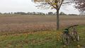
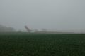
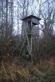
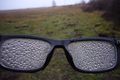
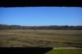
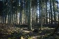
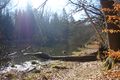
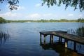
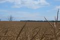
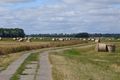
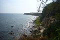
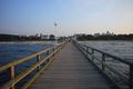
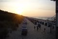
Pictures
Some pictures of my Expeditions. For all my pictures see its Category.