2024-09-11 42 -122
| Wed 11 Sep 2024 in 42,-122: 42.1965910, -122.3427726 geohashing.info google osm bing/os kml crox |
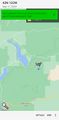
Location
In the woods southeast of Howard Prairie Lake.
Participants
- Michael5000
- BigBrother5000
Expedition
Mrs.5000 and I had driven down to visit my brother, but Mrs. had become sick as a dog and was languishing in the basement. I checked the hashpoints, and my brother was intrigued to see this one out by a place he had occasionally camped, and that was good enough to decide what we were up to for the morning.
After driving out Dead Indian Memorial Road, then Hyatt Prairie Road, then Howard Prairie Dam Road, the roads kept getting smaller and smaller and more loosely defined until we came upon... forest cows! The older ones figured out to get off the road and let us by, but the calves wanted to escape from the vehicle down the path of least resistance, which was the road, which led to some interspecies frustration. But after some zigzagging we got to within a hundred meters or so of the hashpoint.
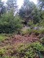
It was kind of a challenging final approach! Jenny Creek was a little bigger and a little more overgrown than anticipated, so it took a little doing to get across it in dignity. And then, the little hill up to the point was unpleasantly steep. But you know how it is. I climbed that sucker.
Doubtless my brother was thrilled to have a winning expedition under his belt (since 2010-08-14 42 -122 was a washout). Whether he thought it was worth it, after he subsequently came down with whatever horrible bug had infected Mrs.5000, I'm sure he's too polite to say.
Photos
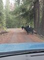
Forest cows!

View from the hashpoint
Me at the hashpoint, from below
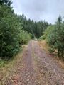
Back to the vehicle
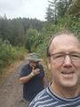
Me and BigBrother

There!
You have to pull way back for any context...


