Difference between revisions of "2012-03-08 19 -155"
imported>Jiml m (Add ribbon indicators) |
imported>Fippe (Location) |
||
| Line 53: | Line 53: | ||
[[Category:Coordinates not reached]] | [[Category:Coordinates not reached]] | ||
[[Category:Not reached - No public access]] | [[Category:Not reached - No public access]] | ||
| + | {{location|US|HI|HA}} | ||
Latest revision as of 18:54, 3 July 2019
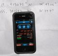
| Thu 8 Mar 2012 in 19,-155: 19.4130725, -155.3416416 geohashing.info google osm bing/os kml crox |
Location
In a cattle pasture just outside Volcanoes National Park. Only a mile or so from the highway.
Participants
Plans
No plans. Spontaneity rules.
Expedition
At 5 pm I decided to try. Sunset was 6:30 pm. Google said the hash was 35 miles away and only a mile or so from the highway. Seemed doable.
Drove up past Volcano through the usual east Hawaii drizzle. A couple of miles past the crest, it dried out and I found a little dirt road leading off through an old a'a field. The road has a locked gate but no signs. There's a convenient parking pullout a few feet away. A nice sunset stroll down the dirt road led to some cattle pastures. Flushed some nene. Followed the GPS through the pastures until I was stopped by a fence, electrified. Only 5 arcsec away! Close, but not close enough to claim success. By that time, it was almost completely dark, so I threw in the towel. Walked back to the car by the light of Venus and Jupiter with the Stygian glow of Kilauea's smoke column close by.
Photos
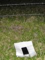
Almost got there. Only 5 arcsec away.
But there's this fence, electrified.

And it's dark.
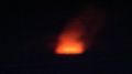
Kilauea is always cool.


Achievements
- No trespassing