Difference between revisions of "2013-06-14 52 13"
imported>Fenmar |
imported>FippeBot m (Location) |
||
| (6 intermediate revisions by 2 users not shown) | |||
| Line 19: | Line 19: | ||
== Location == | == Location == | ||
<!-- where you've surveyed the hash to be --> | <!-- where you've surveyed the hash to be --> | ||
| + | In a small forest next to the Berliner Ring where A10 and A115 meet. | ||
== Participants == | == Participants == | ||
<!-- who attended: If you link to your wiki user name in this section, your expedition will be picked up by the various statistics generated for geohashing. You may use three tildes ~ as a shortcut to automatically insert the user signature of the account you are editing with. | <!-- who attended: If you link to your wiki user name in this section, your expedition will be picked up by the various statistics generated for geohashing. You may use three tildes ~ as a shortcut to automatically insert the user signature of the account you are editing with. | ||
--> | --> | ||
| + | * [[User:Fenmar|Fenmar]] | ||
| + | * [[User:Rialgar|Rialgar]] | ||
== Plans == | == Plans == | ||
<!-- what were the original plans --> | <!-- what were the original plans --> | ||
| + | Start at 1pm in Potsdam, go by bike and be back before 3pm. | ||
== Expedition == | == Expedition == | ||
<!-- how it all turned out. your narrative goes here. --> | <!-- how it all turned out. your narrative goes here. --> | ||
| + | I was checking the hashes near Potsdam for ca. two weeks to find one, which would be good for my first geohash expedition. Today was the day. The hash was about 10km from where I live and located in a small forest which seemed accessible. I asked Rialgar to accompany me and so we decided to go on our first geohashing expedition together. | ||
| − | + | We didn't have much trouble getting there thanks to google navigation and discovered some interesting places in Potsdams outskirts. Who knew there were so many stables around? | |
| − | + | ||
| + | The hashpoint itself was right on the path through the forest, but because orientation is hard we wandered around without direction until we realised that what we thought was north was actually south. Having found the hash we quickly made some photos as proof before we would be completely eaten by the mosquitos. | ||
| + | |||
| + | With a great view at the Berliner Ring we took a break. Rialgar brought some cookies and water. We then left a biodegradable message on the hashpoint and headed back home. | ||
| + | |||
| + | First hash: success. | ||
| + | |||
| + | [https://docs.google.com/file/d/0B1DxM8SFvC8bNS1zdGVrZ0s0OVU/edit?usp=sharing Tracklog] | ||
== Photos == | == Photos == | ||
| Line 38: | Line 50: | ||
--> | --> | ||
<gallery perrow="5"> | <gallery perrow="5"> | ||
| + | 2013_06_14_52_13_nowhere.jpg | On our way to nowhere | ||
| + | 2013_06_14_52_13_windmill.jpg | Through the outskirts of Potsdam | ||
| + | 2013_06_14_52_13_proof.png | Proof that we have been there | ||
| + | 2013_06_14_52_13_hashpoint.jpg | The actual hashpoint | ||
| + | 2013_06_14_52_13_selfshot2.jpg | Photo of us with stupid grin | ||
| + | 2013_06_14_52_13_selfshot1.jpg | And a nice one for the frontpage | ||
| + | 2013_06_14_52_13_food.jpg | Having a break | ||
| + | 2013_06_14_52_13_sign.jpg | Leaving a message | ||
| + | 2013_06_14_52_13_signcomplete.jpg | Geohashing was too long | ||
</gallery> | </gallery> | ||
| Line 43: | Line 64: | ||
{{#vardefine:ribbonwidth|800px}} | {{#vardefine:ribbonwidth|800px}} | ||
<!-- Add any achievement ribbons you earned below, or remove this section --> | <!-- Add any achievement ribbons you earned below, or remove this section --> | ||
| − | + | {{land geohash | latitude = 52 | longitude = 13 | date = 2013-06-14 | name = [[User:Fenmar|Fenmar]] and [[USer:Rialgar|Rialgar]] }} | |
| + | {{Bicycle geohash | latitude = 52 | longitude = 13 | date = 2013-06-14 | name = [[User:Fenmar|Fenmar]] and [[USer:Rialgar|Rialgar]] }} | ||
<!-- =============== USEFUL CATEGORIES FOLLOW ================ | <!-- =============== USEFUL CATEGORIES FOLLOW ================ | ||
Delete the next line ONLY if you have chosen the appropriate categories below. If you are unsure, don't worry. People will read your report and help you with the classification. --> | Delete the next line ONLY if you have chosen the appropriate categories below. If you are unsure, don't worry. People will read your report and help you with the classification. --> | ||
| − | |||
| − | |||
<!-- Potential categories. Please include all the ones appropriate to your expedition --> | <!-- Potential categories. Please include all the ones appropriate to your expedition --> | ||
| − | <!-- | + | <!-- [[Category:Expedition planning]] --> |
| − | [[Category:Expedition planning]] | ||
| − | --> | ||
<!-- An actual expedition: | <!-- An actual expedition: | ||
| − | |||
-- and one or more of -- | -- and one or more of -- | ||
[[Category:Expeditions with photos]] | [[Category:Expeditions with photos]] | ||
| Line 61: | Line 78: | ||
[[Category:Expedition without GPS]] | [[Category:Expedition without GPS]] | ||
--> | --> | ||
| − | + | [[Category:Expeditions]] | |
| + | [[Category:Coordinates reached]] | ||
| + | [[Category:Expeditions with photos]] | ||
<!-- if you reached your coords: | <!-- if you reached your coords: | ||
| − | |||
| Line 82: | Line 100: | ||
(Don't forget to delete this final close comment marker) --> | (Don't forget to delete this final close comment marker) --> | ||
| + | {{location|DE|BB|PM}} | ||
Latest revision as of 02:50, 14 August 2019
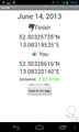
| Fri 14 Jun 2013 in 52,13: 52.3032574, 13.0831953 geohashing.info google osm bing/os kml crox |
Location
In a small forest next to the Berliner Ring where A10 and A115 meet.
Participants
Plans
Start at 1pm in Potsdam, go by bike and be back before 3pm.
Expedition
I was checking the hashes near Potsdam for ca. two weeks to find one, which would be good for my first geohash expedition. Today was the day. The hash was about 10km from where I live and located in a small forest which seemed accessible. I asked Rialgar to accompany me and so we decided to go on our first geohashing expedition together.
We didn't have much trouble getting there thanks to google navigation and discovered some interesting places in Potsdams outskirts. Who knew there were so many stables around?
The hashpoint itself was right on the path through the forest, but because orientation is hard we wandered around without direction until we realised that what we thought was north was actually south. Having found the hash we quickly made some photos as proof before we would be completely eaten by the mosquitos.
With a great view at the Berliner Ring we took a break. Rialgar brought some cookies and water. We then left a biodegradable message on the hashpoint and headed back home.
First hash: success.
Photos

On our way to nowhere

Through the outskirts of Potsdam
Proof that we have been there

The actual hashpoint
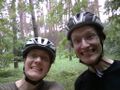
Photo of us with stupid grin

And a nice one for the frontpage

Having a break

Leaving a message

Geohashing was too long


Achievements
Fenmar and Rialgar earned the Land geohash achievement
|
Fenmar and Rialgar earned the Bicycle geohash achievement
|