Difference between revisions of "2013-09-21 -43 172"
imported>Quaternary (→Photos) |
imported>Quaternary (→Tracklog) |
||
| Line 35: | Line 35: | ||
== Tracklog == | == Tracklog == | ||
| − | <! | + | |
| + | <gallery> | ||
| + | Image:2013_09_21_-43_172_Geolocation.PNG| Bingo! | ||
| + | <\gallery> | ||
== Photos == | == Photos == | ||
Revision as of 10:18, 21 September 2013
| Sat 21 Sep 2013 in -43,172: -43.3735723, 172.7089212 geohashing.info google osm bing/os kml crox |
Location
Pines Beach, Canterbury, NZ
Participants
Plans
Wow - what a great hash site - a beach - and on a Saturday.
What a shame the weather is so sub-optimal, but nevertheless, we are planning on being there at 4pm today. Maybe see some of you there?
Expedition
The rain stopped precipitating early afternoon - perfect timing, and we arrived at the spot around 3:30pm. It was at the top of a sand-dune about 200m from the edge of the Pacific Ocean - Ideal! So a lovely day out for dad, mum and the kids. We found a bit of driftwood that served as a marker-pole. On the strike of 4pm it started raining again, so sand-castling stopped for the day, and we headed back to civilisation. Oh, and we also found a geocache on the way, about 200 metres from the hash-point.
Tracklog
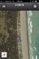
Bingo!
- == Photos ==
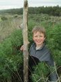
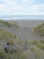
The pole marks the spot
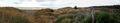
Panorama
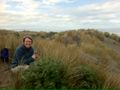
Understanding partner
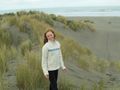
Understanding daughter
Let's head to the beach
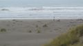
Collecting shells
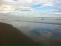
The Pacific Ocean


Achievements
Quaternary earned the GeoTrash Geohash Achievement
|