Difference between revisions of "2015-07-26 51 1"
imported>Sourcerer m ([live picture] Water. [http://www.openstreetmap.org/?lat=51.98201001&lon=1.12643123&zoom=16&layers=B000FTF @51.9820,1.1264]) |
imported>Sourcerer m (→New Expedition) |
||
| Line 20: | Line 20: | ||
== Expedition == | == Expedition == | ||
| + | *Arrived. -- [[User:Sourcerer|Sourcerer]] ([[User talk:Sourcerer|talk]]) [http://www.openstreetmap.org/?lat=51.98201001&lon=1.12644732&zoom=16&layers=B000FTF @51.9820,1.1264] 21:38, 26 July 2015 (GMT+01:00) | ||
| + | This was a very pleasant location. Alton Water is a man-made reservoir with foot and cycle paths all round it. The small part I sampled was delightful, if damp. The hashpoint was close to the water. Close by, there was a tall poll with a platform on top that looked like a stork's nest. No stork was in evidence. I have only ever seen them in Portugal and Andalusia, much further south. Lower on the same poll there was an owl box with a lot of hissing noises coming out. | ||
| − | |||
| − | |||
== Photos == | == Photos == | ||
<gallery perrow="5"> | <gallery perrow="5"> | ||
| − | |||
Image:2015-07-26_51_1_Sourcerer_1437942962323.jpg | Proof. [http://www.openstreetmap.org/?lat=51.98200464&lon=1.12644196&zoom=16&layers=B000FTF @51.9820,1.1264] | Image:2015-07-26_51_1_Sourcerer_1437942962323.jpg | Proof. [http://www.openstreetmap.org/?lat=51.98200464&lon=1.12644196&zoom=16&layers=B000FTF @51.9820,1.1264] | ||
| − | + | Image:2015-07-26_51_1_Sourcerer_1437942379653.jpg | Alton Water. [http://www.openstreetmap.org/?lat=51.98201001&lon=1.12643123&zoom=16&layers=B000FTF @51.9820,1.1264] | |
| − | Image:2015-07-26_51_1_Sourcerer_1437942379653.jpg | Water. [http://www.openstreetmap.org/?lat=51.98201001&lon=1.12643123&zoom=16&layers=B000FTF @51.9820,1.1264] | + | Image:2015-07-26_51_1_Sourcerer.jpg | Track in Google Earth |
</gallery> | </gallery> | ||
| Line 41: | Line 40: | ||
| date = 2015-07-26 | | date = 2015-07-26 | ||
| OSMlink = 32853100 | | OSMlink = 32853100 | ||
| + | | name = Sourcerer | ||
| + | }} | ||
| + | {{consecutive geohash 2 | ||
| + | | count = 3 | ||
| + | | latitude = 52 | ||
| + | | longitude = 1 | ||
| + | | date = 2015-07-24 | ||
| name = Sourcerer | | name = Sourcerer | ||
}} | }} | ||
| Line 51: | Line 57: | ||
}} | }} | ||
| − | |||
| − | |||
[[Category:Expeditions]] | [[Category:Expeditions]] | ||
[[Category:Expeditions with photos]] | [[Category:Expeditions with photos]] | ||
[[Category:Coordinates reached]] | [[Category:Coordinates reached]] | ||
| − | |||
Revision as of 01:04, 27 July 2015
| Sun 26 Jul 2015 in 51,1: 51.9820071, 1.1264572 geohashing.info google osm bing/os kml crox |
Location
On the south side of Alton Water, Suffolk, UK.
Participants
Plans
Expedition one of two spanning midnight - 2015-07-26 51 1 - 2015-07-27 52 0 - ETA 21:46
Expedition
- Arrived. -- Sourcerer (talk) @51.9820,1.1264 21:38, 26 July 2015 (GMT+01:00)
This was a very pleasant location. Alton Water is a man-made reservoir with foot and cycle paths all round it. The small part I sampled was delightful, if damp. The hashpoint was close to the water. Close by, there was a tall poll with a platform on top that looked like a stork's nest. No stork was in evidence. I have only ever seen them in Portugal and Andalusia, much further south. Lower on the same poll there was an owl box with a lot of hissing noises coming out.
Photos
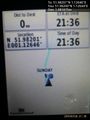
Proof. @51.9820,1.1264
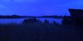
Alton Water. @51.9820,1.1264
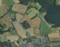
Track in Google Earth


Achievements
Sourcerer earned the OpenStreetMap achievement
|
Sourcerer earned the Consecutive geohash achievement
|
Expeditions and Plans
| 2015-07-26 | ||
|---|---|---|
| Young, Australia | Someone went | In the "south-bound" kerb-side lane of the Hume Highway near Young, New South Wales... |
| San Francisco, California | Codae | On a hillside in Martinez, California. |
| Newark, New Jersey | OtherJack, Liz | A thickly wooded front garden in Ridgewood |
| Canterbury, United Kingdom | Sourcerer | On the south side of Alton Water, Suffolk, UK. |
Sourcerer's Expedition Links
2015-07-25 52 0 - 2015-07-26 51 1 - 2015-07-27 52 0 - KML file download of Sourcerer's expeditions for use with Google Earth.