Difference between revisions of "2015-08-06 51 13"
imported>Danatar (Report, finally!) |
imported>FippeBot m (Location) |
||
| (One intermediate revision by one other user not shown) | |||
| Line 42: | Line 42: | ||
===tracklog=== | ===tracklog=== | ||
| − | + | [http://www.everytrail.com/view_trip.php?trip_id=3409894&code=51696b2270de94ae64d101ba4a712fd8 triton tracklog] | |
| Line 49: | Line 49: | ||
[[Category:Coordinates reached]] | [[Category:Coordinates reached]] | ||
[[Category:Danatar]] | [[Category:Danatar]] | ||
| + | {{location|DE|SN|DD}} | ||
Latest revision as of 04:42, 15 August 2019
| Thu 6 Aug 2015 in Dresden: 51.0400912, 13.7803015 geohashing.info google osm bing/os kml crox |
Location
Today's location is on private property on Geisingstraße in Dresden-Striesen, according to the satellite image the spot is in a house.
Country: Germany; state: Sachsen (Saxony, EU:DE:SN); district: Dresden; Ortsamt: Blasewitz; statistischer Stadtteil: Striesen-Süd
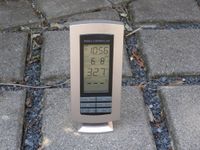
Weather: 32.7 °C at 11 a.m.
Danatar
Planning
I will walk there and take a look at the house. As the hashpoint is only 700-750 meters from my house, reaching it would mean another Couch Potato Honorable Mention for me. I don't think that I'll reach the spot.
Expedition
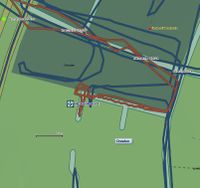
I knew that some day there would be a hashpoint in Striesen. In preparation, I visited every accessible spot in Striesen over the winter. Every street, every footpath, the parks, most of the publicly accessible backyards (those of apartment blocks that is), and the occasional allotment garden or schoolyard when the gates stood open. The only exceptions were places that were closed because of construction work or that had no trespassing signs. It took me a few weeks, see the déjà-vu tracklog here
As can be seen on the tracklog (which has strongly reduced trackpoints because of the everytrail.com upload), I have been in the backyard of the Institut für Luft- und Kältetechnik gGmbH ("Institute of Air Handling and Refrigeration") research & development non-profit enterprise, about 15 meters north of the hashpoint, and on the small path that leads to the hashproperty, about 10 meters east of the spot.
The first visit to the hashpoint was in the night, after work. From work I cycled through Striesen and to the path that led to the hashhouse. I was there around 01:20 and I walked along the property, not getting nearer than 6 or 7 meters even when standing at the house's front door. Then I went home and slept.
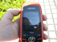
In the morning I started around 10:40 and walked towards the spot. It was already over 30 °C. I was back at the place around 10:50 and again I walked along the property, again not getting any nearer. It would have been possible to get about one or two meters nearer, but I would have had to step on the small path that lead to the garden. While the path to the front door is okay, anything further is clearly private property. I took some pictures, including of the thermometer that I had put in the shade in front of the house which showed 32.7 °C. Then I walked back home.
|


