Difference between revisions of "2015-08-14 52 1"
imported>Sourcerer (→Planning) |
imported>FippeBot m (Location) |
||
| (10 intermediate revisions by one other user not shown) | |||
| Line 3: | Line 3: | ||
| lon=1 | | lon=1 | ||
| date=2015-08-14 | | date=2015-08-14 | ||
| + | | graticule_name=Norwich, UK | ||
| + | | graticule_link=Norwich, United Kingdom | ||
}} | }} | ||
__NOTOC__ | __NOTOC__ | ||
| Line 8: | Line 10: | ||
== Location == | == Location == | ||
| − | + | 25 metres north of a public footpath, west of Kirton, Suffolk, UK. | |
== Participants == | == Participants == | ||
| Line 16: | Line 18: | ||
== Plans == | == Plans == | ||
| + | Expedition one of two spanning midnight - [[2015-08-14 52 1]] - [[2015-08-15 52 1]] - ETA 22:40. | ||
| + | == Expedition == | ||
| + | *Arrived. -- [[User:Sourcerer|Sourcerer]] ([[User talk:Sourcerer|talk]]) [http://www.openstreetmap.org/?lat=52.00773239&lon=1.30593538&zoom=16&layers=B000FTF @52.0077,1.3059] 22:24, 14 August 2015 (GMT+01:00) | ||
| − | + | This was easy to find because it was close to hashpoints I had visited earlier. There was a public footpath / farm access road. This swung round to the right and the hashpoint was in the stubble of a wheat or barley field about 25 metres from the path. | |
| + | On the return journey, I passed 35 metres from the [[2014-04-27 52 1|Black Tiles Pub Geohash]] visited 16 months ago. | ||
| + | This was a bit of a landmark day, being the first day of my retirement from teaching although technically my contract ends on August 31<sup>st</sup> and I taught my last lesson back in May. My final task yesterday was to get my students' exam results. They all passed so I went home happy. | ||
== Photos == | == Photos == | ||
<gallery perrow="5"> | <gallery perrow="5"> | ||
| + | Image:2015-08-14_52_1_Sourcerer_1439587419447.jpg | Proof. [http://www.openstreetmap.org/?lat=52.00773239&lon=1.30593538&zoom=16&layers=B000FTF @52.0077,1.3059] | ||
| + | Image:2015-08-14 52 1 Sourcerer.jpg | Track in Google Earth | ||
</gallery> | </gallery> | ||
== Achievements == | == Achievements == | ||
{{#vardefine:ribbonwidth|700px}} | {{#vardefine:ribbonwidth|700px}} | ||
| + | {{A Tale of Two Hashes challenge | ||
| + | | latitude = 52 | ||
| + | | longitude = 1 | ||
| + | | date = 2015-08-14 | ||
| + | | name = Sourcerer | ||
| + | | place = Innocence (lane) | ||
| + | }} | ||
{{Sourcerer_links | {{Sourcerer_links | ||
| Line 37: | Line 53: | ||
}} | }} | ||
| − | + | ||
| − | |||
[[Category:Expeditions]] | [[Category:Expeditions]] | ||
[[Category:Expeditions with photos]] | [[Category:Expeditions with photos]] | ||
[[Category:Coordinates reached]] | [[Category:Coordinates reached]] | ||
| − | + | {{location|GB|ENG|SFK}} | |
Latest revision as of 04:47, 15 August 2019
| Fri 14 Aug 2015 in Norwich, UK: 52.0077248, 1.3059386 geohashing.info google osm bing/os kml crox |
Location
25 metres north of a public footpath, west of Kirton, Suffolk, UK.
Participants
Plans
Expedition one of two spanning midnight - 2015-08-14 52 1 - 2015-08-15 52 1 - ETA 22:40.
Expedition
- Arrived. -- Sourcerer (talk) @52.0077,1.3059 22:24, 14 August 2015 (GMT+01:00)
This was easy to find because it was close to hashpoints I had visited earlier. There was a public footpath / farm access road. This swung round to the right and the hashpoint was in the stubble of a wheat or barley field about 25 metres from the path.
On the return journey, I passed 35 metres from the Black Tiles Pub Geohash visited 16 months ago.
This was a bit of a landmark day, being the first day of my retirement from teaching although technically my contract ends on August 31st and I taught my last lesson back in May. My final task yesterday was to get my students' exam results. They all passed so I went home happy.
Photos
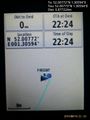
Proof. @52.0077,1.3059
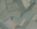
Track in Google Earth


Achievements

Expeditions and Plans
| 2015-08-14 | ||
|---|---|---|
| Mannheim, Germany | elimik31 | Close to the Rhine harbor in Karlsruhe, 10 m from a gravel track in a fores... |
| Frankfurt am Main, Germany | Tads | on a playground in Mainz-Kostheim |
| Halle (Saale), Germany | Reinhard | At the hillside of inglorious Ettersberg north of Weimar, Germany. |
| Norwich, United Kingdom | Sourcerer | 25 metres north of a public footpath, west of Kirton, Suffolk, UK. |
Sourcerer's Expedition Links
2015-08-12 52 1 - 2015-08-14 52 1 - 2015-08-15 52 1 - KML file download of Sourcerer's expeditions for use with Google Earth.