Difference between revisions of "2008-06-24 47 -121"
From Geohashing
imported>Thomcat m (use template correctly) |
imported>FippeBot m (Location) |
||
| (2 intermediate revisions by one other user not shown) | |||
| Line 11: | Line 11: | ||
Just off Highway 2 near Gold Bar, and darn close ... hey, wait a minute. This geohash is 1.965 miles west of the [[2008-06-19 47 -121|previous]] one in the same graticule! | Just off Highway 2 near Gold Bar, and darn close ... hey, wait a minute. This geohash is 1.965 miles west of the [[2008-06-19 47 -121|previous]] one in the same graticule! | ||
| + | |||
| + | == Participants == | ||
| + | *[[User:Thomcat|Thomcat]] | ||
==Expeditions== | ==Expeditions== | ||
| Line 38: | Line 41: | ||
[[Category:Expeditions]] | [[Category:Expeditions]] | ||
[[Category:Expeditions with photos]] | [[Category:Expeditions with photos]] | ||
| + | [[Category:Coordinates reached]] | ||
| + | {{location|US|WA|SN}} | ||
Latest revision as of 05:26, 7 August 2019
| Tue 24 Jun 2008 in Snoqualmie: 47.8443138, -121.7292753 geohashing.info google osm bing/os kml crox |
Contents
About
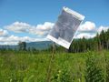
Just off Highway 2 near Gold Bar, and darn close ... hey, wait a minute. This geohash is 1.965 miles west of the previous one in the same graticule!
Participants
Expeditions
Thomcat
No Zeke's this time. I drove to Sultan then south on the the access road, up to this point. As Indiana Jones said, "We walk from here".

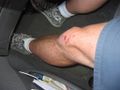
Walked (and jogged - I was a little past 4:00) roughy a mile down a road also used by many horses. I got close to the spot, then had to go cross country. Brambles, thorns, and stickers weren't going to stop me this time, and no kids to worry about.


Overall, a very pretty scene. On the way back out, I saw more horses and took a better picture of the gate. Once I got back to the car, I staunched the major bleeding and drove to my baseball game. Success!
MNIMB!

