Difference between revisions of "2021-03-18 67 24"
From Geohashing
(Created page with "{{subst:Expedition}}") |
m (Location) |
||
| (10 intermediate revisions by one other user not shown) | |||
| Line 14: | Line 14: | ||
__NOTOC__ | __NOTOC__ | ||
== Location == | == Location == | ||
| − | + | In swamp ~200meters from road. | |
== Participants == | == Participants == | ||
<!-- who attended: If you link to your wiki user name in this section, your expedition will be picked up by the various statistics generated for geohashing. You may use three tildes ~ as a shortcut to automatically insert the user signature of the account you are editing with. | <!-- who attended: If you link to your wiki user name in this section, your expedition will be picked up by the various statistics generated for geohashing. You may use three tildes ~ as a shortcut to automatically insert the user signature of the account you are editing with. | ||
--> | --> | ||
| + | |||
| + | [[User:Bysmyyr|Bysmyyr]] ([[User talk:Bysmyyr|talk]]) with Tapsa | ||
== Plans == | == Plans == | ||
<!-- what were the original plans --> | <!-- what were the original plans --> | ||
| + | First visit Äkäskerö mountain and then check the Hash which looks to be in easy location with snowshoes. | ||
== Expedition == | == Expedition == | ||
<!-- how it all turned out. your narrative goes here. --> | <!-- how it all turned out. your narrative goes here. --> | ||
| + | Everything went as planned. Only problem was that there was no cell coverage in hash area. | ||
== Tracklog == | == Tracklog == | ||
| Line 34: | Line 38: | ||
--> | --> | ||
<gallery perrow="5"> | <gallery perrow="5"> | ||
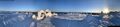
| + | Image:photo5954213343013221702.jpg|Äkäskerö | ||
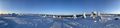
| + | Image:photo5954213343013221704.jpg|Äkäskerö | ||
| + | Image:photo5954213343013221703.jpg|Äkäskerö | ||
| + | Image:photo5954213343013221702 (1).jpg|stupid grin | ||
| + | Image:photo5954213343013221708.jpg|gps | ||
</gallery> | </gallery> | ||
| Line 41: | Line 50: | ||
<!-- =============== USEFUL CATEGORIES FOLLOW ================ | <!-- =============== USEFUL CATEGORIES FOLLOW ================ | ||
| − | |||
| − | |||
| − | |||
| − | |||
| − | |||
| − | |||
| − | |||
| − | |||
| − | |||
<!-- If all those plans are never acted upon, change [[Category:Expedition planning]] to [[Category:Not reached - Did not attempt]]. --> | <!-- If all those plans are never acted upon, change [[Category:Expedition planning]] to [[Category:Not reached - Did not attempt]]. --> | ||
| − | |||
[[Category:Expeditions]] | [[Category:Expeditions]] | ||
| − | |||
[[Category:Expeditions with photos]] | [[Category:Expeditions with photos]] | ||
| − | + | ||
| − | |||
| − | |||
| − | |||
| − | |||
[[Category:Coordinates reached]] | [[Category:Coordinates reached]] | ||
| − | + | {{location|FI|10}} | |
| − | |||
| − | |||
| − | |||
| − | |||
| − | |||
| − | |||
| − | |||
| − | |||
| − | |||
| − | |||
| − | |||
| − | |||
| − | |||
| − | |||
| − | |||
| − | |||
| − | |||
Revision as of 19:42, 18 March 2021
| Thu 18 Mar 2021 in 67,24: 67.7379008, 24.3239204 geohashing.info google osm bing/os kml crox |
Location
In swamp ~200meters from road.
Participants
Plans
First visit Äkäskerö mountain and then check the Hash which looks to be in easy location with snowshoes.
Expedition
Everything went as planned. Only problem was that there was no cell coverage in hash area.
Tracklog
Photos

Äkäskerö
Äkäskerö
Äkäskerö
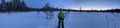
stupid grin
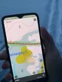
gps
