Difference between revisions of "2021-12-09 -37 144"
(Add location and expedition log.) |
(Add additional image) |
||
| Line 1: | Line 1: | ||
| − | + | ||
{{meetup graticule | {{meetup graticule | ||
| Line 26: | Line 26: | ||
== Photos == | == Photos == | ||
<gallery> | <gallery> | ||
| + | File:PXL 20211209 022815917.jpg|Idyllic parkland that formed part of the route | ||
File:Geohash 2021-12-09 -37 144 03 GPS.png|GPS Proof | File:Geohash 2021-12-09 -37 144 03 GPS.png|GPS Proof | ||
File:Geohash 2021-12-09 -37 144 02 Map.png|Map of the hash | File:Geohash 2021-12-09 -37 144 02 Map.png|Map of the hash | ||
Revision as of 02:58, 9 December 2021
| Thu 9 Dec 2021 in -37,144: -37.8363460, 144.9268709 geohashing.info google osm bing/os kml crox |
Location
Page Avenue, Port Melbourne.
Participants
Expedition
When my geohashing buddies alerted me to this one, I knew that I just had to take it. It was right along the route that I use to take my son to Gymnastics, which I knew I could access with an absolute minimum of road cycling. Once on the linear reserve along the Port Melbourne tram line, I knew that I would be cycling through idyllic parkland all the way to the hash.
From Google street view, I knew that the hash lay just slightly within someone's front yard, but I was betting that my arm would be long enough to reach the spot without technically trespassing. I wasn't wrong.
Tracklog
Use the tracklog template like this: {{tracklog|Name of the tracklog file.gpx}}
Photos

Idyllic parkland that formed part of the route
GPS Proof
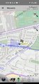
Map of the hash
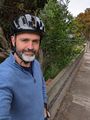
Rob at the hash


Achievements
rwh earned the Bicycle geohash achievement
|