Difference between revisions of "2010-07-17 53 -116"
imported>B cereus (Created page with '{{meetup graticule | lat=53 | lon=-116 | date=2010-07-13 }} __NOTOC__ == Location == On Yellowhead highway, just west of Edson. (actually 150m south of the highway) == Partic…') |
m |
||
| (5 intermediate revisions by 3 users not shown) | |||
| Line 2: | Line 2: | ||
| lat=53 | | lat=53 | ||
| lon=-116 | | lon=-116 | ||
| − | | date=2010-07- | + | | date=2010-07-17 |
}} | }} | ||
| Line 17: | Line 17: | ||
== Expedition == | == Expedition == | ||
| − | I successfully speedracered the hash and got a Slurpee at a nearby 7-11. A couple days later though, I discovered that the hash wasn't | + | I successfully speedracered the hash and got a Slurpee at a nearby 7-11. A couple days later though, I discovered that the hash wasn't where my iPhone said it ways, and the 7-11 was 1.2km outside the 5km limit for Geosquishy ribbons. Google maps app now snaps the Geohash app output point to roads, after OS4 update for the iPhone. The actual hash point is 150m south of the false point. GAH... At least I got a sweet ass Slurpee. |
== Photos == | == Photos == | ||
<gallery perrow="4"> | <gallery perrow="4"> | ||
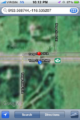
| − | Image:2010-07-17 53 -116 | + | Image:2010-07-17 53 -116 05.PNG | 7-11 to hashpoint --> 6.2km |
| − | Image:2010-07-17 53 -116 02.JPG | | + | Image:2010-07-17 53 -116 02.JPG | Mmmmm frogwater slurpee |
| − | Image:2010-07-17 53 -116 03.JPG | | + | Image:2010-07-17 53 -116 03.JPG | Looks more like a frog slurpee |
| − | Image:2010-07-17 53 -116 04.JPG | | + | Image:2010-07-17 53 -116 04.JPG | Tastes like awesome |
| − | Image:2010-07-17 53 -116 | + | Image:2010-07-17 53 -116 06.JPG | Proof for attempted Speedracer ribbon |
| − | Image:2010-07-17 53 -116 | + | Image:2010-07-17 53 -116 01.PNG | False snap to road location... |
</gallery> | </gallery> | ||
| Line 40: | Line 40: | ||
[[Category:Coordinates not reached]] | [[Category:Coordinates not reached]] | ||
[[Category:Expeditions with photos]] | [[Category:Expeditions with photos]] | ||
| + | [[Category:Not reached - Technology]] | ||
| + | {{location|CA|AB|YH}} | ||
Latest revision as of 21:40, 14 March 2022
| Sat 17 Jul 2010 in 53,-116: 53.5687441, -116.5352076 geohashing.info google osm bing/os kml crox |
Location
On Yellowhead highway, just west of Edson. (actually 150m south of the highway)
Participants
Plans
On my way back home for casing break, I saw that there are drive by hash points here and in the adjacent graticule.
Expedition
I successfully speedracered the hash and got a Slurpee at a nearby 7-11. A couple days later though, I discovered that the hash wasn't where my iPhone said it ways, and the 7-11 was 1.2km outside the 5km limit for Geosquishy ribbons. Google maps app now snaps the Geohash app output point to roads, after OS4 update for the iPhone. The actual hash point is 150m south of the false point. GAH... At least I got a sweet ass Slurpee.
Photos
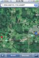
7-11 to hashpoint --> 6.2km
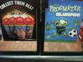
Mmmmm frogwater slurpee
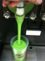
Looks more like a frog slurpee
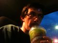
Tastes like awesome
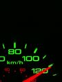
Proof for attempted Speedracer ribbon
False snap to road location...


B cereus earned the Blinded by Science Consolation Prize
|