Difference between revisions of "2022-05-04 62 29"
(Created page with "{{Subst:Expedition}}") |
m (subst-ing) |
||
| (4 intermediate revisions by 2 users not shown) | |||
| Line 1: | Line 1: | ||
| − | + | {{meetup graticule | |
| − | + | | lat=62 | |
| − | + | | lon=29 | |
| − | + | | date=2022-05-04 | |
| − | |||
| − | |||
| − | |||
| − | |||
| − | |||
| − | | lat= | ||
| − | | lon= | ||
| − | | date= | ||
}}<!-- edit as necessary --> | }}<!-- edit as necessary --> | ||
__NOTOC__ | __NOTOC__ | ||
== Location == | == Location == | ||
| − | + | In a forest near Ahokkala, Kontiolahti. | |
| + | |||
| + | The point on a topographic map: {{MapSiteLink | lat = 62.7138005 | lon = 29.9068783 | title = Geohash+2022-05-04+62+29}} | ||
== Participants == | == Participants == | ||
| − | + | * [[User:Kripakko|Kripakko]] | |
| − | + | ||
| + | == Expedition == | ||
| + | At last, a reasonably accessible hashpoint on a day when I do not have too much other stuff to do. I would have to cycle about 15 kilometres each way and walk a little in the forest. It is already late enough spring, so there would not be too much snow. I set off at about 19:50. The sun was shining at low altitude and about to set later at 21:23. The temperature was 5 °C, and it would go down to 0 °C by the time I got back home two hours later. | ||
| − | + | Nothing particularly interesting happened. I cycled to the nearest point on the road, locked the bicycle and jogged to the hashpoint. I ended up doing a small detour because I was not paying enough attention to the GPS receiver screen, and GPS seemed to dance a lot at the hashpoint as well. There was enough snow in some points in the forest that some got in my boots. It should all be gone in a week or two except in very shady places. | |
| − | |||
| − | + | According to my GPS receiver, the length of my trip was 31.0 km, of which I cycled 30.5 km and walked 0.5 km. | |
| − | |||
== Tracklog == | == Tracklog == | ||
| − | + | {{tracklog | 2022-05-04 62 29 tracklog.gpx}} | |
== Photos == | == Photos == | ||
| − | < | + | <gallery perrow="4"> |
| − | Image: | + | Image:2022-05-04_62_29_01-gpsr1.jpg | Proof of location. |
| − | -- | + | Image:2022-05-04_62_29_02-gpsr2.jpg | Proof of date and time. |
| − | + | Image:2022-05-04_62_29_03-selfie.jpg | Selfie at the hashpoint. | |
| + | Image:2022-05-04_62_29_04-coltsfoot.jpg | A coltsfoot (''Tussilago farfara'') growing by the road, a sure sign of approaching summer. | ||
</gallery> | </gallery> | ||
| − | == | + | == Video == |
| − | + | I filmed most of the journey to the geohash with an action camera that I had attached on my head. There is nothing particularly interesting at any point, so feel free to skip ahead. | |
| − | |||
| − | |||
| − | |||
| − | |||
| − | |||
| − | < | + | <youtube>https://youtu.be/0s7KAqpZ01M</youtube> |
| − | + | YouTube link: [https://youtu.be/0s7KAqpZ01M] | |
| − | |||
| − | |||
| − | |||
| − | + | == Achievements == | |
| + | {{#vardefine:ribbonwidth|800px}} | ||
| + | {{land geohash | date = 2022-05-04 | latitude = 62 | longitude = 29 | name = Kripakko}} | ||
| + | {{bicycle geohash | date = 2022-05-04 | latitude = 62 | longitude = 29 | name = Kripakko | distance = 30.5 km | bothways = true}} | ||
| − | |||
[[Category:Expeditions]] | [[Category:Expeditions]] | ||
| − | |||
[[Category:Expeditions with photos]] | [[Category:Expeditions with photos]] | ||
[[Category:Expeditions with videos]] | [[Category:Expeditions with videos]] | ||
| − | |||
| − | |||
| − | |||
| − | |||
[[Category:Coordinates reached]] | [[Category:Coordinates reached]] | ||
| − | + | {{location|FI|13}} | |
| − | |||
| − | |||
| − | |||
| − | |||
| − | |||
| − | |||
| − | |||
| − | |||
| − | |||
| − | |||
| − | |||
| − | |||
| − | |||
| − | |||
| − | |||
| − | |||
| − | |||
Latest revision as of 20:47, 24 May 2024
| Wed 4 May 2022 in 62,29: 62.7138005, 29.9068783 geohashing.info google osm bing/os kml crox |
Location
In a forest near Ahokkala, Kontiolahti.
The point on a topographic map: [1]
Participants
Expedition
At last, a reasonably accessible hashpoint on a day when I do not have too much other stuff to do. I would have to cycle about 15 kilometres each way and walk a little in the forest. It is already late enough spring, so there would not be too much snow. I set off at about 19:50. The sun was shining at low altitude and about to set later at 21:23. The temperature was 5 °C, and it would go down to 0 °C by the time I got back home two hours later.
Nothing particularly interesting happened. I cycled to the nearest point on the road, locked the bicycle and jogged to the hashpoint. I ended up doing a small detour because I was not paying enough attention to the GPS receiver screen, and GPS seemed to dance a lot at the hashpoint as well. There was enough snow in some points in the forest that some got in my boots. It should all be gone in a week or two except in very shady places.
According to my GPS receiver, the length of my trip was 31.0 km, of which I cycled 30.5 km and walked 0.5 km.
Tracklog
Photos
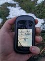
Proof of location.
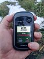
Proof of date and time.
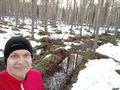
Selfie at the hashpoint.
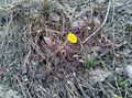
A coltsfoot (Tussilago farfara) growing by the road, a sure sign of approaching summer.


Video
I filmed most of the journey to the geohash with an action camera that I had attached on my head. There is nothing particularly interesting at any point, so feel free to skip ahead.
YouTube link: [2]
Achievements
Kripakko earned the Land geohash achievement
|
Kripakko earned the Bicycle geohash achievement
|