Difference between revisions of "The Dalles, Oregon"
imported>Michael5000 m (→Expedition History) |
Michael5000 (talk | contribs) (→2023) |
||
| (35 intermediate revisions by 10 users not shown) | |||
| Line 13: | Line 13: | ||
}} | }} | ||
| − | [[File:The Dalles.jpg| | + | [[File:The Dalles.jpg|550 px]] |
| − | The central area of The Dalles graticule is taken up by Oregon's Hood River Valley, a lightly settled agricultural and orchard district. Its main town, Hood River, is set in the narrow Columbia River Gorge, as are White Salmon, Washington and The Dalles, Oregon, the other two larger towns in the area. | + | The central area of The Dalles [[graticule]] is taken up by Oregon's Hood River Valley, a lightly settled agricultural and orchard district. Its main town, Hood River, is set in the narrow Columbia River Gorge, as are White Salmon, Washington and The Dalles, Oregon, the other two larger towns in the area. |
| − | Although the Gorge is a transportation corridor and US highways 26 and 95 both cut through the graticule, much of the area is difficult to find access to. Hashpoints seem to often be on the other side of the creek, river, or cliff from the geohasher. Mountains of the Cascade range, including towering Mt. Hood, dominate the western half of the | + | Although the Gorge is a transportation corridor and US highways 26 and 95 both cut through the graticule, much of the area is difficult to find access to. Hashpoints seem to often be on the other side of the creek, river, or cliff from the geohasher. Mountains of the Cascade range, including towering Mt. Hood, dominate the western half of the graticule, with the eastern edge starting into the dry canyon-cut wheatlands of North Central Oregon and Eastern Washington. |
== Expedition History == | == Expedition History == | ||
| − | ''' | + | ===2024=== |
| + | |||
| + | '''[[2024-05-29 45 -121]]''' -- [[User:Mrs.5000|Mrs.5000]] and [[User:Michael5000|Michael5000]] visit Bonneville Dam. | ||
| + | |||
| + | ===2023=== | ||
| + | |||
| + | '''[[2023-07-09 45 -121]]''' -- [[User:Hamblingreen|Hamblingreen]] and family trek up a forest road north of Stevenson, leaving evidence for [[User:Michael5000|Michael5000]] to find later. | ||
| + | |||
| + | '''[[2023-05-06 45 -121]]''' -- [[User:Thomcat|Thomcat]] doesn't make it to Carpenters Lake. | ||
| + | |||
| + | ===2022=== | ||
| + | |||
| + | '''[[2022-07-08 45 -121]]''' -- [[User:Michael5000|Michael5000]] and [[User:Mrs.5000|Mrs.5000]] have a dramatic drive to The Dalles. | ||
| + | |||
| + | '''[[2022-07-01 45 -121]]''' -- [[User:Michael5000|Michael5000]], [[User:Mrs.5000|Mrs.5000]], Jennifer, and Brian drive to a spot overlooking the East Fork Hood River. | ||
| + | |||
| + | '''[[2022-04-06 45 -121]]''' -- [[User:Michael5000|Michael5000]] makes the first expedition to this graticule in a moderately long to long while. | ||
| + | |||
| + | ===2019=== | ||
| + | |||
| + | '''[[2019-08-04 45 -121]]''' -- [[User:Michael5000|Michael5000]] tries to reach a hashpoint in the Multnomah County portion of the graticule, but is defeated by brush and brambles. | ||
| + | |||
| + | '''[[2019-06-05 45 -121]]''' -- [[User:Michael5000|Michael5000]] makes the first expedition to this graticule in a moderately long while. | ||
| + | |||
| + | ===2018=== | ||
| + | |||
| + | '''[[2018-06-15 45 -121]]''' -- [[User:Frogman|Frogman]] and [[User:Higgs|Higgs]] make the first expedition to this graticule in a long while. | ||
| + | |||
| + | ===2013=== | ||
| + | |||
| + | '''[[2013-08-03 45 -121]]''' -- [[User:Michael5000|Michael5000]] finds a hashpoint on the Washington slope of the Gorge. | ||
| + | |||
| + | ===2012=== | ||
| + | |||
| + | There appear to have been 7 expeditions to the graticule in 2012. | ||
===2011=== | ===2011=== | ||
| − | [[2011-07-31 45 -121]] -- [[User:Michael5000|Michael5000]] makes an early morning visit to a hashpoint just off Highway 26. | + | There appear to have been 3 additional expeditions to the graticule in late 2011. |
| + | |||
| + | '''[[2011-09-22 45 -121]]''' -- [[User:kydlt|Kydlt]] visits a spot by the railroad near Cascade Locks; [[User:Michael5000|Michael5000]] visits the same spot several hours later. | ||
| + | |||
| + | '''[[2011-09-20 45 -121]]''' -- [[User:Michael5000|Michael5000]] makes an early afternoon visit to a hashpoint just off Highway 197. | ||
| + | |||
| + | [[2011-09-17 45 -121]] -- [[User:kydlt|Kydlt]] can't quite get to a spot northwest of Carson. | ||
| + | |||
| + | [[2011-09-10 45 -121]] -- [[User:kydlt|Kydlt]] and some friends are daunted by wilderness near Panther Creek Falls. | ||
| + | |||
| + | '''[[2011-08-08 45 -121]]''' -- [[User:kydlt|Kydlt]] is on the same side of all creeks, rivers, and cliffs as the hashpoint. | ||
| + | |||
| + | '''[[2011-07-31 45 -121]]''' -- [[User:Michael5000|Michael5000]] makes an early morning visit to a hashpoint just off Highway 26. | ||
| + | |||
| + | [[2011-06-10 45 -121]] -- [[User:kydlt|Kydlt]] is thwarted by gates and parking permit requirements. | ||
| + | |||
| + | '''[[2011-05-25 45 -121]]''' -- [[User:kydlt|Kydlt]] reaches a spot in the woods northeast of Carson. First successful hash of the Washington side of this graticule! | ||
[[User:kydlt|Kydlt]] tried to visit a hash on [[2011-05-22 45 -121|2011-05-22]] but it was just north of where I was, that is, across the river. I was about 100 ft short. I see a pattern here. | [[User:kydlt|Kydlt]] tried to visit a hash on [[2011-05-22 45 -121|2011-05-22]] but it was just north of where I was, that is, across the river. I was about 100 ft short. I see a pattern here. | ||
| Line 31: | Line 81: | ||
[[User:kydlt|Kydlt]] tried to visit a hash on [[2011-03-02 45 -121|2011-03-02]] but it was just south of where I was, that is, out in the river. I was about 100 ft short. | [[User:kydlt|Kydlt]] tried to visit a hash on [[2011-03-02 45 -121|2011-03-02]] but it was just south of where I was, that is, out in the river. I was about 100 ft short. | ||
| − | [[User:kydlt|Kydlt]] tried to visit a hash on [[2011-02-10|2011-02-10]] but missed. It was over the cliff & the other side of the creek. | + | [[User:kydlt|Kydlt]] tried to visit a hash on [[2011-02-10|2011-02-10]] but missed. It was over the cliff & the other side of the creek. |
| − | |||
===2010=== | ===2010=== | ||
| − | [[User:Jiml|Jiml]] and [[User:Aperfectring|Aperfectring]] visited a hashpoint here on [[2010-02-15 45 -121|2010-02-15]], if you visited a hashpoint on an earlier date, award yourself the [[ | + | [[User:Jiml|Jiml]] and [[User:Aperfectring|Aperfectring]] visited a hashpoint here on '''[[2010-02-15 45 -121|2010-02-15]]''', if you visited a hashpoint on an earlier date, award yourself the [[Graticule Unlocked]] achievement, and let Jiml and Aperfectring know. |
| − | {{ | + | {{Graticule unlocked |
| latitude = 45 | | latitude = 45 | ||
| Line 47: | Line 96: | ||
}} | }} | ||
| − | [[Category: | + | ==Local Graticule Makes Good== |
| + | |||
| + | [[File:Dalles in Third.jpg|frame|left|On September 24, 2011, The Dalles graticule was tied for third for most expeditions in the month.]] | ||
| + | |||
| + | [[Category:Active graticules]] | ||
[[Category:Oregon]] | [[Category:Oregon]] | ||
[[Category:Washington]] | [[Category:Washington]] | ||
| + | [[Category:Unlocked graticules]] | ||
Latest revision as of 04:40, 31 May 2024
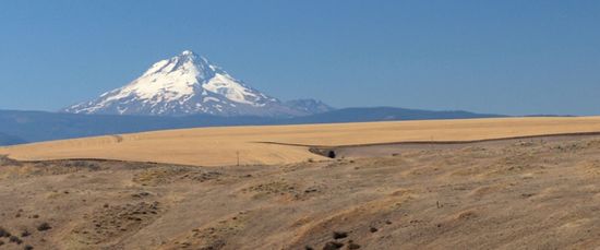
The central area of The Dalles graticule is taken up by Oregon's Hood River Valley, a lightly settled agricultural and orchard district. Its main town, Hood River, is set in the narrow Columbia River Gorge, as are White Salmon, Washington and The Dalles, Oregon, the other two larger towns in the area.
Although the Gorge is a transportation corridor and US highways 26 and 95 both cut through the graticule, much of the area is difficult to find access to. Hashpoints seem to often be on the other side of the creek, river, or cliff from the geohasher. Mountains of the Cascade range, including towering Mt. Hood, dominate the western half of the graticule, with the eastern edge starting into the dry canyon-cut wheatlands of North Central Oregon and Eastern Washington.
Contents
Expedition History
2024
2024-05-29 45 -121 -- Mrs.5000 and Michael5000 visit Bonneville Dam.
2023
2023-07-09 45 -121 -- Hamblingreen and family trek up a forest road north of Stevenson, leaving evidence for Michael5000 to find later.
2023-05-06 45 -121 -- Thomcat doesn't make it to Carpenters Lake.
2022
2022-07-08 45 -121 -- Michael5000 and Mrs.5000 have a dramatic drive to The Dalles.
2022-07-01 45 -121 -- Michael5000, Mrs.5000, Jennifer, and Brian drive to a spot overlooking the East Fork Hood River.
2022-04-06 45 -121 -- Michael5000 makes the first expedition to this graticule in a moderately long to long while.
2019
2019-08-04 45 -121 -- Michael5000 tries to reach a hashpoint in the Multnomah County portion of the graticule, but is defeated by brush and brambles.
2019-06-05 45 -121 -- Michael5000 makes the first expedition to this graticule in a moderately long while.
2018
2018-06-15 45 -121 -- Frogman and Higgs make the first expedition to this graticule in a long while.
2013
2013-08-03 45 -121 -- Michael5000 finds a hashpoint on the Washington slope of the Gorge.
2012
There appear to have been 7 expeditions to the graticule in 2012.
2011
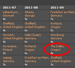
There appear to have been 3 additional expeditions to the graticule in late 2011.
2011-09-22 45 -121 -- Kydlt visits a spot by the railroad near Cascade Locks; Michael5000 visits the same spot several hours later.
2011-09-20 45 -121 -- Michael5000 makes an early afternoon visit to a hashpoint just off Highway 197.
2011-09-17 45 -121 -- Kydlt can't quite get to a spot northwest of Carson.
2011-09-10 45 -121 -- Kydlt and some friends are daunted by wilderness near Panther Creek Falls.
2011-08-08 45 -121 -- Kydlt is on the same side of all creeks, rivers, and cliffs as the hashpoint.
2011-07-31 45 -121 -- Michael5000 makes an early morning visit to a hashpoint just off Highway 26.
2011-06-10 45 -121 -- Kydlt is thwarted by gates and parking permit requirements.
2011-05-25 45 -121 -- Kydlt reaches a spot in the woods northeast of Carson. First successful hash of the Washington side of this graticule!
Kydlt tried to visit a hash on 2011-05-22 but it was just north of where I was, that is, across the river. I was about 100 ft short. I see a pattern here.
Kydlt tried to visit a hash on 2011-03-02 but it was just south of where I was, that is, out in the river. I was about 100 ft short.
Kydlt tried to visit a hash on 2011-02-10 but missed. It was over the cliff & the other side of the creek.
2010
Jiml and Aperfectring visited a hashpoint here on 2010-02-15, if you visited a hashpoint on an earlier date, award yourself the Graticule Unlocked achievement, and let Jiml and Aperfectring know.
Jim and APR earned the Graticule Unlocked Achievement
|

