Difference between revisions of "Flensburg, Germany"
From Geohashing
imported>Fippe (Tønder → Westerland) |
Gaboversta (talk | contribs) |
||
| (14 intermediate revisions by 3 users not shown) | |||
| Line 14: | Line 14: | ||
}} | }} | ||
| − | + | {{Today's location|lat=54|lon=9}} | |
According to [[Land usage]], the chance for your hash to fall into one of the following areas is: | According to [[Land usage]], the chance for your hash to fall into one of the following areas is: | ||
| Line 26: | Line 26: | ||
1.36% Settlements | 1.36% Settlements | ||
</pre> | </pre> | ||
| + | |||
| + | ===Maps and stats=== | ||
| + | [[File:Region 54,9 Admin 4.svg|200px]] | ||
| + | {| class="wikitable" | ||
| + | !Name!!Code!!area type!!Country!!Geohash<br />probability | ||
| + | |- | ||
| + | |<span style="color:rgba(237,244,168,255)">■</span> Schleswig-Holstein||DE-SH||land||Germany||81.6% | ||
| + | |- | ||
| + | |<span style="color:rgba(241,189,244,255)">■</span> Syddanmark||DK-83||land||Denmark||13.1% | ||
| + | |- | ||
| + | |<span style="color:rgba(217,239,211,255)">■</span> Schleswig-Holstein||DE-SH||incl. waters||Germany||84.2% | ||
| + | |- | ||
| + | |<span style="color:rgba(220,212,249,255)">■</span> Denmark||DK||incl. waters||Denmark||15.8% | ||
| + | |} | ||
| Line 35: | Line 49: | ||
== Past Expeditions == | == Past Expeditions == | ||
| + | * [[2024-09-19 54 9]] in the city forest of Neumünster, by [[User:gaboversta|gaboversta]]. | ||
| + | * [[2023-08-28 54 9]] in a forest in Krähenberg, by [[User:Fippe|Fippe]]. | ||
* [[2015-05-27 54 9]] on the road of the former B4 in Neumünster-Einfeld by [[User:GeorgDerReisende|GeorgDerReisende]]. | * [[2015-05-27 54 9]] on the road of the former B4 in Neumünster-Einfeld by [[User:GeorgDerReisende|GeorgDerReisende]]. | ||
* [[2012-06-21 54 9]] in a copse on the bank of Nord-Ostsee-Kanal near Rendsburg/A7. [[User:Koryu|Koryu]] was there and left a hashmark. | * [[2012-06-21 54 9]] in a copse on the bank of Nord-Ostsee-Kanal near Rendsburg/A7. [[User:Koryu|Koryu]] was there and left a hashmark. | ||
| Line 43: | Line 59: | ||
[[Category:Denmark]] | [[Category:Denmark]] | ||
[[Category:Germany]] | [[Category:Germany]] | ||
| − | [[Category: | + | [[Category:Active graticules]] |
Latest revision as of 21:48, 19 September 2024
| Esbjerg, Denmark | Kolding, Denmark | Odense, Denmark |
| Westerland | Flensburg | Kiel |
| Bremen | Hamburg (West) | Hamburg (East) |
|
Today's location: geohashing.info google osm bing/os kml crox | ||
According to Land usage, the chance for your hash to fall into one of the following areas is:
73.74%	Fields
10.06%	Natural reserves
7.24%	Water
3.14%	Forests
3.02%	Roads
1.44%	Highways
1.36%	Settlements
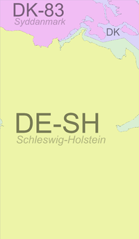
Maps and stats
| Name | Code | area type | Country | Geohash probability |
|---|---|---|---|---|
| ■ Schleswig-Holstein | DE-SH | land | Germany | 81.6% |
| ■ Syddanmark | DK-83 | land | Denmark | 13.1% |
| ■ Schleswig-Holstein | DE-SH | incl. waters | Germany | 84.2% |
| ■ Denmark | DK | incl. waters | Denmark | 15.8% |
Local Geohashers
Blinker1980
Current hashes, attendance plans
none currently
Past Expeditions
- 2024-09-19 54 9 in the city forest of Neumünster, by gaboversta.
- 2023-08-28 54 9 in a forest in Krähenberg, by Fippe.
- 2015-05-27 54 9 on the road of the former B4 in Neumünster-Einfeld by GeorgDerReisende.
- 2012-06-21 54 9 in a copse on the bank of Nord-Ostsee-Kanal near Rendsburg/A7. Koryu was there and left a hashmark.
- 2012-06-04 54 9 in a forest near Waldhuetten, attempted by Koryu but not reached because of a fence.
- 2009-08-27 54 9 in a meadow near Rickert, about 5 km north of Rendsburg. dawidi from 49 12 (again on vacation in Kiel) was there.
- 2009-06-23 54 9 in a field near Krummwisch, about 15km west of Kiel. dawidi from 49 12 went there, but couldn't get closer than 180m without trampling the crops.
