Difference between revisions of "2024-11-29 47 11"
From Geohashing
| (7 intermediate revisions by the same user not shown) | |||
| Line 11: | Line 11: | ||
== Expedition == | == Expedition == | ||
| − | *[[User:Iqui|Iqui]]: | + | *[[User:Iqui|Iqui]]: I went there by bike, picking up various geocaches along the way. Thankfully the hash was close to the street, because the forest-like part next to it, where the hash was located, was not that easy to travers, partly due to there being lots of thorn bushes on the ground. I initially wanted to drive back home by bike too, but my phone battery was getting low and I knew it was going to be difficult to find through Munich without it. And because it was also becoming fairly cold outside, I decided to take the train home. |
== Photos == | == Photos == | ||
| − | <gallery mode="packed" heights=" | + | <gallery mode="packed" heights="150px"> |
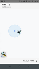
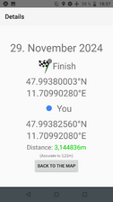
2024-11-29 47 11 proof 1.png | proof 1 | 2024-11-29 47 11 proof 1.png | proof 1 | ||
2024-11-29 47 11 proof 2.png | proof 2 | 2024-11-29 47 11 proof 2.png | proof 2 | ||
2024-11-29 47 11 me at location.jpeg | me at location | 2024-11-29 47 11 me at location.jpeg | me at location | ||
2024-11-29 47 11 location 2.jpeg | location | 2024-11-29 47 11 location 2.jpeg | location | ||
| − | 2024-11-29 47 11 | + | 2024-11-29 47 11 public transport proof.jpeg | in the S7 |
</gallery> | </gallery> | ||
| Line 27: | Line 27: | ||
== Achievements == | == Achievements == | ||
{{#vardefine:ribbonwidth|100%}} | {{#vardefine:ribbonwidth|100%}} | ||
| − | {{land geohash | latitude = 47 | longitude = 11 | date = 2024-11-29 | name = [[User:Iqui|Iqui]] | image = 2024-11-29 47 11 location.jpeg }} | + | {{land geohash | latitude = 47 | longitude = 11 | date = 2024-11-29 | name = [[User:Iqui|Iqui]] | image = 2024-11-29 47 11 location 2.jpeg }} |
{{bicycle geohash | latitude = 47 | longitude = 11 | date = 2024-11-29 | name = [[User:Iqui|Iqui]] | distance = 48,4 km }} | {{bicycle geohash | latitude = 47 | longitude = 11 | date = 2024-11-29 | name = [[User:Iqui|Iqui]] | distance = 48,4 km }} | ||
Latest revision as of 16:05, 30 November 2024
| Fri 29 Nov 2024 in 47,11: 47.9938000, 11.7099028 geohashing.info google osm bing/os kml crox |
Location
In a forest in Brunnthal
Participants
Expedition
- Iqui: I went there by bike, picking up various geocaches along the way. Thankfully the hash was close to the street, because the forest-like part next to it, where the hash was located, was not that easy to travers, partly due to there being lots of thorn bushes on the ground. I initially wanted to drive back home by bike too, but my phone battery was getting low and I knew it was going to be difficult to find through Munich without it. And because it was also becoming fairly cold outside, I decided to take the train home.
Photos
Tracklog
Achievements
Iqui earned the Land geohash achievement
|
Iqui earned the Bicycle geohash achievement
|


