Difference between revisions of "2009-02-11 33 -84"
imported>Woodveil (New page: {{meetup graticule | map=<map lat="33" lon="-84" date="2009-02-11" /> | lat=33 | lon=-84 | date=2009-02-11 | graticule_name=Atlanta | graticule_link=Atlanta, Georgia }} == About == These...) |
imported>FippeBot m (Location) |
||
| (4 intermediate revisions by 3 users not shown) | |||
| Line 20: | Line 20: | ||
=== [[User:NWoodruff|NWoodruff]] === | === [[User:NWoodruff|NWoodruff]] === | ||
| − | + | I-285 south bound east of the city was a parking lot at the 6pm and 7pm hour as in it had been raining heavily and there were several car wrecks. Every time I contemplated turning around and heading back for home, a gap in traffic would open up. I eventually made it past the lane closure and to I-20 heading east. I did print out a Google map to make sure I did come close as possible to the hash point. Success! I drove through the hash around 7:15pm. I did not have my camera with me. No pictures were taken :(. | |
== Gallery == | == Gallery == | ||
| Line 34: | Line 34: | ||
== Achievements == | == Achievements == | ||
| − | {{land geohash | latitude = 33 | longitude = -84 | date = 2009- | + | {{land geohash | latitude = 33 | longitude = -84 | date = 2009-02-11 | name = [[user:NWoodruff|NWoodruff]] and [[user:Woodveil|Woodveil]]}} |
| − | {{Speed | + | {{Speed racer | latitude = 33 | longitude = -84 | date = 2009-02-11 | name = [[user:NWoodruff|NWoodruff]] and [[user:Woodveil|Woodveil]]}} |
[[Category:Expeditions]] | [[Category:Expeditions]] | ||
[[Category:Expeditions with photos]] | [[Category:Expeditions with photos]] | ||
[[Category:Coordinates reached]] | [[Category:Coordinates reached]] | ||
| + | {{location|US|GA|RO}} | ||
Latest revision as of 01:49, 8 August 2019
| Wed 11 Feb 2009 in Atlanta: 33.6545786, -84.0082915 geohashing.info google osm bing/os kml crox |
About
These coordinates were in the far East of the graticule, and were directly on I20! In an Eastbound lane, just after an onramp (Exit 82, in case you were wondering). Not that it mattered much, but weather was ~68°F and overcast.
Expedition
Woodveil
We had a break in classes and hit up the point a few minutes after 1:00. It took us a couple runs to get satisfactory evidence, and even then the closest reading we could photograph is 13.3 feet. It takes a little more timing when you're going 65 miles per hour. But what the hell, it was fun.
NWoodruff
I-285 south bound east of the city was a parking lot at the 6pm and 7pm hour as in it had been raining heavily and there were several car wrecks. Every time I contemplated turning around and heading back for home, a gap in traffic would open up. I eventually made it past the lane closure and to I-20 heading east. I did print out a Google map to make sure I did come close as possible to the hash point. Success! I drove through the hash around 7:15pm. I did not have my camera with me. No pictures were taken :(.
Gallery
- Photo Gallery
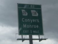
The hash was in Conyers, Georgia.
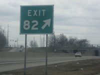
Yep, 82.
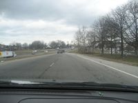
The onramp in question.
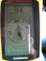
GPS proof. If speed were displayed, it'd have shown about 65 mph.


Achievements
NWoodruff and Woodveil earned the Land geohash achievement
|
