Difference between revisions of "2009-06-06 59 18"
imported>LoneTech (Starting to work on report.) |
imported>FippeBot m (Location) |
||
| (5 intermediate revisions by one other user not shown) | |||
| Line 1: | Line 1: | ||
| + | <!-- If you did not specify these parameters in the template, please substitute appropriate things for IMAGE, LAT, LON, and DATE (YYYY-MM-DD format) --> | ||
| + | |||
| + | [[Image:{{{image|2009_06_06_59_18_geohashers.jpg}}}|thumb|left]] | ||
| − | |||
| − | |||
| − | |||
| − | |||
{{meetup graticule | {{meetup graticule | ||
| lat=59 | | lat=59 | ||
| Line 13: | Line 12: | ||
__NOTOC__ | __NOTOC__ | ||
== Participants == | == Participants == | ||
| + | [[User:LoneTech|Yann Vernier]], Robert Lövlie, [[User:Gnitset|Klas Meder Boqvist]] | ||
| + | == Plans == | ||
| + | The geohash wound up in a forest near Klas' home. We planned to go there at 16:00, but with no other known active geohashers here we didn't plan to stay for long. | ||
| − | == | + | == Expedition == |
| + | We met up in Vallentuna, where Klas and I (Yann) had helped another friend move. From there we first went to Klas' home, planning to get a camera, though we wound up with just our cellphones again. Something about uncharged batteries. | ||
| + | Going back to the vicinity of the geohash, we took a small dirt road to the edge of the forest and parked the car by the corner of a field, so it wouldn't block the road. We then walked the rest of the way, mostly along the edge of the forest since the terrain inside was harder to traverse. | ||
| − | + | As we reached the point, we found that the GPSr we used (my Nokia E71 cellphone) was a bit unreliable; the point seemed to move about a few meters, as far as it could tell. So we don't have a full 6-decimal match but this time we definitely could go anywhere it was, and with our confused tracking most likely did cover the spot. Success noted, we took a few pictures, and trudged back to the car. One roe deer was spotted on the way back. | |
| + | When we reached our car, we were approached by a local who was wondering who we were, also warning us of wild boar in the region. Along he had a huge half-breed dog - a German shepherd mixed with wolf. Luckily they were both friendly, with the man known to Klas, and we chatted for a while about what we were doing there. He found the concept quite amusing, and we swapped some stories of wildlife meetings. As we stood there, both a car and a forestry machine passed on the dirt road, showing more traffic than I would have expected. When we left we caught up with the machine. | ||
== Tracklog == | == Tracklog == | ||
| + | To be uploaded. | ||
| + | == Photos == | ||
| − | |||
| − | <gallery perrow=" | + | <gallery perrow="4"> |
| − | Image:2009- | + | Image:2009_06_06_59_18_geohashers.jpg | Three happy geohashers. |
| − | Image:2009- | + | Image:2009-06-06_59_18_forestrymachine.jpg | Hardware is always fun. |
| + | Image:2009-06-06_59_18_car.jpg | Had to leave the car to carry on on foot. | ||
| + | Image:2009-06-06_59_18_bigdog.jpg | Dog or wolf? Try both. | ||
</gallery> | </gallery> | ||
| + | |||
<!-- Potential categories. Please include all the ones appropriate to your expedition --> | <!-- Potential categories. Please include all the ones appropriate to your expedition --> | ||
| Line 36: | Line 45: | ||
--> | --> | ||
| − | |||
| − | |||
| − | |||
[[Category:Expeditions]] | [[Category:Expeditions]] | ||
[[Category:Expeditions with photos]] | [[Category:Expeditions with photos]] | ||
| + | <!-- | ||
[[Category:Expeditions with videos]] | [[Category:Expeditions with videos]] | ||
[[Category:Expedition without GPS]] | [[Category:Expedition without GPS]] | ||
--> | --> | ||
| − | |||
[[Category:Coordinates reached]] | [[Category:Coordinates reached]] | ||
| − | + | {{location|SE|AB}} | |
| − | |||
| − | |||
| − | |||
| − | |||
| − | |||
| − | |||
| − | |||
| − | |||
| − | |||
Latest revision as of 03:46, 8 August 2019

| Sat 6 Jun 2009 in 59,18: 59.6184255, 18.2322508 geohashing.info google osm bing/os kml crox |
Participants
Yann Vernier, Robert Lövlie, Klas Meder Boqvist
Plans
The geohash wound up in a forest near Klas' home. We planned to go there at 16:00, but with no other known active geohashers here we didn't plan to stay for long.
Expedition
We met up in Vallentuna, where Klas and I (Yann) had helped another friend move. From there we first went to Klas' home, planning to get a camera, though we wound up with just our cellphones again. Something about uncharged batteries.
Going back to the vicinity of the geohash, we took a small dirt road to the edge of the forest and parked the car by the corner of a field, so it wouldn't block the road. We then walked the rest of the way, mostly along the edge of the forest since the terrain inside was harder to traverse.
As we reached the point, we found that the GPSr we used (my Nokia E71 cellphone) was a bit unreliable; the point seemed to move about a few meters, as far as it could tell. So we don't have a full 6-decimal match but this time we definitely could go anywhere it was, and with our confused tracking most likely did cover the spot. Success noted, we took a few pictures, and trudged back to the car. One roe deer was spotted on the way back.
When we reached our car, we were approached by a local who was wondering who we were, also warning us of wild boar in the region. Along he had a huge half-breed dog - a German shepherd mixed with wolf. Luckily they were both friendly, with the man known to Klas, and we chatted for a while about what we were doing there. He found the concept quite amusing, and we swapped some stories of wildlife meetings. As we stood there, both a car and a forestry machine passed on the dirt road, showing more traffic than I would have expected. When we left we caught up with the machine.
Tracklog
To be uploaded.
Photos
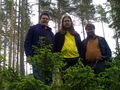
Three happy geohashers.
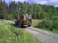
Hardware is always fun.
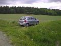
Had to leave the car to carry on on foot.
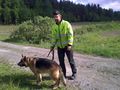
Dog or wolf? Try both.


