Difference between revisions of "2009-08-09 39 -106"
imported>ChrisMillbern (→Final Result) |
m (per Renaming Proposal) |
||
| (5 intermediate revisions by 3 users not shown) | |||
| Line 11: | Line 11: | ||
Starting down the I70 highway, I was already impressed with the beauty of the state. Rolling mountains of pine trees, huge rock formations, and the Colorado River decorated the edges of the road. After a quick traffic jam, I was able to make it to Frisco, Colorado. I was happily surprised by a detour- right in front of me, a huge art fair was in progress and I stopped for a visit. The art was great, the people were better, and I highly recommend anyone in the area to stop by. The town is simply great. | Starting down the I70 highway, I was already impressed with the beauty of the state. Rolling mountains of pine trees, huge rock formations, and the Colorado River decorated the edges of the road. After a quick traffic jam, I was able to make it to Frisco, Colorado. I was happily surprised by a detour- right in front of me, a huge art fair was in progress and I stopped for a visit. The art was great, the people were better, and I highly recommend anyone in the area to stop by. The town is simply great. | ||
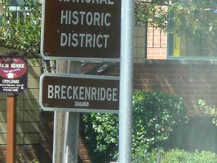
I then made it to Breckenridge, and they also had an art fair going on. Although I didn’t stay nearly as long, my advice above applies equally to this town too. The goal was just outside the city, near some residential areas way up on a mountain. After driving into a dead end, running into a golf course where there should have been a road, and getting as lost as lost can be, I managed to get lucky and take an unnamed road straight to the intersection I was looking for. I soon disembarked from my car, and climbed up an extremely steep and extremely forested hill for quite a while. Crossing the 10,000 foot altitude, I checked my GPS, corrected my position and made it to the geohash. | I then made it to Breckenridge, and they also had an art fair going on. Although I didn’t stay nearly as long, my advice above applies equally to this town too. The goal was just outside the city, near some residential areas way up on a mountain. After driving into a dead end, running into a golf course where there should have been a road, and getting as lost as lost can be, I managed to get lucky and take an unnamed road straight to the intersection I was looking for. I soon disembarked from my car, and climbed up an extremely steep and extremely forested hill for quite a while. Crossing the 10,000 foot altitude, I checked my GPS, corrected my position and made it to the geohash. | ||
| + | |||
| + | [[Image:2009-08-09 39 -106 2.jpg]] | ||
== Final Result == | == Final Result == | ||
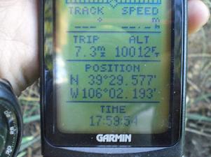
At an altitude of 10,012 feet, this geohash expedition is the highest geohash to date. This was done in the Vail, Colorado graticule on August 9th, 2009. | At an altitude of 10,012 feet, this geohash expedition is the highest geohash to date. This was done in the Vail, Colorado graticule on August 9th, 2009. | ||
| − | [[Image:2009-08- | + | [[Image:2009-08-09_39_-106.jpg]] |
== Achievements == | == Achievements == | ||
| Line 22: | Line 24: | ||
{{land geohash | latitude = 39 | longitude = -106 | date = 2009-08-09 | name = Chris Millbern }} | {{land geohash | latitude = 39 | longitude = -106 | date = 2009-08-09 | name = Chris Millbern }} | ||
| − | {{ | + | {{Graticule unlocked | latitude = 39 | longitude = -106 | date = 2009-08-09 | name = Chris Millbern }} |
'''Links''' | '''Links''' | ||
[[User:ChrisMillbern| Chris Millbern]] | [[User:ChrisMillbern| Chris Millbern]] | ||
| + | |||
| + | [[Category:Expeditions]] | ||
| + | [[Category:Expeditions with photos]] | ||
| + | [[Category:Coordinates reached]] | ||
| + | {{location|US|CO|SU}} | ||
Latest revision as of 06:26, 20 March 2024
| Sun 9 Aug 2009 in 39,-106: 39.4929400, -106.0338846 geohashing.info google osm bing/os kml crox |
Preparation
August 9th, 2009- While staying temporarily in Gypsum, I decided an adventure was in order. Equipped with an old GPS and a Ford Mustang I set out to break the highest geohash record. I had looked on Friday to see if I'd be lucky enough to get a nearby geohash (with the needed altitude). Sunday looked perfect, so Breckenridge it was.
The Adventure
Starting down the I70 highway, I was already impressed with the beauty of the state. Rolling mountains of pine trees, huge rock formations, and the Colorado River decorated the edges of the road. After a quick traffic jam, I was able to make it to Frisco, Colorado. I was happily surprised by a detour- right in front of me, a huge art fair was in progress and I stopped for a visit. The art was great, the people were better, and I highly recommend anyone in the area to stop by. The town is simply great. I then made it to Breckenridge, and they also had an art fair going on. Although I didn’t stay nearly as long, my advice above applies equally to this town too. The goal was just outside the city, near some residential areas way up on a mountain. After driving into a dead end, running into a golf course where there should have been a road, and getting as lost as lost can be, I managed to get lucky and take an unnamed road straight to the intersection I was looking for. I soon disembarked from my car, and climbed up an extremely steep and extremely forested hill for quite a while. Crossing the 10,000 foot altitude, I checked my GPS, corrected my position and made it to the geohash.
Final Result
At an altitude of 10,012 feet, this geohash expedition is the highest geohash to date. This was done in the Vail, Colorado graticule on August 9th, 2009.
Achievements
Chris Millbern earned the High geohash achievement
|
Chris Millbern earned the Land geohash achievement
|
Chris Millbern earned the Graticule Unlocked Achievement
|
Links Chris Millbern

