Difference between revisions of "2009-09-07 31 -97"
imported>Bbgun06 (→Expedition) |
imported>FippeBot m (Location) |
||
| (5 intermediate revisions by 2 users not shown) | |||
| Line 21: | Line 21: | ||
== Expedition == | == Expedition == | ||
| − | I left my room | + | I left my room on Ft. Hood at about 1:15. Drove about 45 minutes to the area just north of Troy, Tx. It took a while to find the right place becuase I hadn't figured out how to enter the coordinates into my gps receiver. And the spot that it appeared to be on Google maps was a bit off. But, I found it after parking in a vacant lot and walking about 100 yards. The point was next to a fenceline in an unused cow pasture. I didn't see anyone else or any signs that anyone had been there before me. I left a note and took a few pictures. In all, a fairly easy trip for my first geohashing experience. |
| − | |||
== Tracklog == | == Tracklog == | ||
| Line 35: | Line 34: | ||
--> | --> | ||
<gallery perrow="3"> | <gallery perrow="3"> | ||
| + | Image:2009-09-07 31 -97a.JPG|GPS view, date and time are wrong. | ||
| + | Image:2009-09-07 31 -97b.JPG|I made this little sign, similar to others I have seen on this site. | ||
| + | Image:2009-09-07 31 -97c.JPG|Looking north from the point. | ||
| + | Image:2009-09-07 31 -97d.JPG|Looking East. | ||
| + | Image:2009-09-07 31 -97e.JPG|This trailer appeared to be abandoned, so it made a convenient parking spot. | ||
| + | </gallery> | ||
| − | + | [[Category:Expeditions]] | |
| + | [[Category:Expeditions with photos]] | ||
| + | [[Category:Coordinates reached]] | ||
| Line 64: | Line 71: | ||
[[Category:Failed - Did not attempt]] | [[Category:Failed - Did not attempt]] | ||
--> | --> | ||
| + | {{location|US|TX|BL}} | ||
Latest revision as of 05:39, 8 August 2019
| Mon 7 Sep 2009 in 31,-97: 31.2468975, -97.3119703 geohashing.info google osm bing/os kml crox |
Location
Near Big Elm rd in Troy, Tx.
Participants
bbgun06 so far...
Plans
Drive out there around 1:00
Expedition
I left my room on Ft. Hood at about 1:15. Drove about 45 minutes to the area just north of Troy, Tx. It took a while to find the right place becuase I hadn't figured out how to enter the coordinates into my gps receiver. And the spot that it appeared to be on Google maps was a bit off. But, I found it after parking in a vacant lot and walking about 100 yards. The point was next to a fenceline in an unused cow pasture. I didn't see anyone else or any signs that anyone had been there before me. I left a note and took a few pictures. In all, a fairly easy trip for my first geohashing experience.
Tracklog
Photos
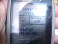
GPS view, date and time are wrong.
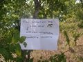
I made this little sign, similar to others I have seen on this site.
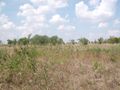
Looking north from the point.
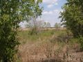
Looking East.
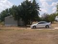
This trailer appeared to be abandoned, so it made a convenient parking spot.


