Difference between revisions of "2010-01-31 33 -84"
imported>NWoodruff (→NWoodruff) |
imported>FippeBot m (Location) |
||
| (One intermediate revision by one other user not shown) | |||
| Line 47: | Line 47: | ||
{{Land geohash | latitude = 33 | longitude = -84| date = 2010-01-31| name = NWoodruff}} | {{Land geohash | latitude = 33 | longitude = -84| date = 2010-01-31| name = NWoodruff}} | ||
| + | {{consecutive geohash | count = 1 | latitude = 33 | longitude = -84 | date = 2010-01-31 | name = NWoodruff }} | ||
| Line 52: | Line 53: | ||
[[Category:Expeditions with photos]] | [[Category:Expeditions with photos]] | ||
[[Category:Coordinates reached]] | [[Category:Coordinates reached]] | ||
| + | {{location|US|GA|CA}} | ||
Latest revision as of 00:39, 9 August 2019
| Sun 31 Jan 2010 in Atlanta: 33.3697908, -84.8551778 geohashing.info google osm bing/os kml crox |
Graticule
About
In a landfill west on Newnan Georgia.
Expedition
NWoodruff
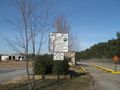
Today is a nice and sunny day here in the Atlanta Graticule. It is still on the cold side, middle 40's, but a nice day for a drive. I drive south to Newnan where the hash spot is. As I was driving up the last 1/2 mile I noticed a sign that said that this place will be permanently closed. I took a picture from the drives side window and proceeded on. As I drive up there are two iron bar gates blocking the drive up to the guard shack. There is a walk way in-between the two gates that allow you to walk up the the shack.
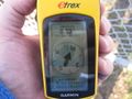
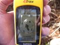
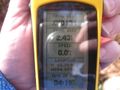
I walk up and nobody home. I look around for a few seconds and then decide to make the 0.16 mile walk to the hash spot. I find the hash spot with 2.43 feet to go. Close enough. I take a few pictures and then walk back to my car. This time I took the Taurus instead of driving the truck.
On my way back I explore Newnan for a few and find a nice place to get something to eat. After getting a stomach full, I then drive home to Norcross.
Gallery
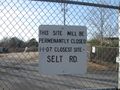
Oppsss. A sign on the drive up.
0.23 miles to go from the sign.
There is nothing stopping you from walking up to the front guard shack.
2.43 feet to go. Close enough.
Time of the meetup.
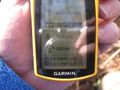
Date of the meetup.
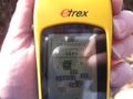
12 feet accuracy.
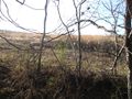
Looking west up the hill.
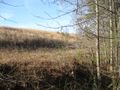
Looking North along the tree line.
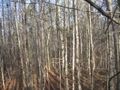
Looking east into the woods.


LuxMundi
Achievements
NWoodruff earned the Land geohash achievement
|
NWoodruff earned the Consecutive geohash achievement
|