Difference between revisions of "2011-01-08 48 14"
From Geohashing
imported>Masterbase |
imported>FippeBot m (Location) |
||
| (2 intermediate revisions by 2 users not shown) | |||
| Line 14: | Line 14: | ||
}} | }} | ||
| − | + | ||
__NOTOC__ | __NOTOC__ | ||
== Location == | == Location == | ||
| − | + | ||
A field in Allerheiligen im Mühlkreis, Austria | A field in Allerheiligen im Mühlkreis, Austria | ||
== Participants == | == Participants == | ||
| − | + | ||
| − | * User:Masterbase | + | * [[User:Masterbase|Masterbase]] |
* FotoJunky | * FotoJunky | ||
== Plans == | == Plans == | ||
| − | + | ||
No Plan at all :) | No Plan at all :) | ||
== Expedition == | == Expedition == | ||
| − | |||
| − | |||
| − | |||
| − | + | It was getting foggier and foggier as we got closer to the hash. When we finally arrived, it was already getting dark and we couldn't see further than 5m(16 feet). | |
| − | + | We tried to park the car and go into the field and reach the the geohash which was (according to Google maps) | |
| − | + | about 10 yards into the field, but we couldn't | |
| + | |||
| + | Also the GPS coordinates jumped around more than 10 yards. | ||
| + | I think this qualifies as a achieved geohash, especially for a first timer. | ||
| + | If this is not the case, please correct me. | ||
| + | |||
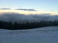
| + | As we were about to start our way home, we were able to get this not-so-foggy picture below. | ||
== Photos == | == Photos == | ||
| − | + | ||
| − | |||
| − | |||
<gallery perrow="5"> | <gallery perrow="5"> | ||
Image:2011-01-08_48_14_field.jpg|The field with todays geohash | Image:2011-01-08_48_14_field.jpg|The field with todays geohash | ||
| Line 49: | Line 50: | ||
== Achievements == | == Achievements == | ||
{{#vardefine:ribbonwidth|800px}} | {{#vardefine:ribbonwidth|800px}} | ||
| − | |||
| + | * Land Geohash | ||
| + | * Virgin Graticule? | ||
| − | |||
| − | |||
| − | |||
| − | |||
| − | |||
| − | |||
[[Category:Expeditions]] | [[Category:Expeditions]] | ||
[[Category:Expeditions with photos]] | [[Category:Expeditions with photos]] | ||
| − | + | ||
| − | |||
| − | |||
| − | |||
| − | |||
[[Category:Coordinates reached]] | [[Category:Coordinates reached]] | ||
| − | + | {{location|AT|OÖ|PE}} | |
| − | |||
| − | |||
| − | |||
| − | |||
| − | |||
| − | |||
| − | |||
| − | |||
Latest revision as of 05:10, 9 August 2019
| Sat 8 Jan 2011 in 48,14: 48.2864810, 14.6481846 geohashing.info google osm bing/os kml crox |
Location
A field in Allerheiligen im Mühlkreis, Austria
Participants
- Masterbase
- FotoJunky
Plans
No Plan at all :)
Expedition
It was getting foggier and foggier as we got closer to the hash. When we finally arrived, it was already getting dark and we couldn't see further than 5m(16 feet).
We tried to park the car and go into the field and reach the the geohash which was (according to Google maps) about 10 yards into the field, but we couldn't
Also the GPS coordinates jumped around more than 10 yards. I think this qualifies as a achieved geohash, especially for a first timer. If this is not the case, please correct me.
As we were about to start our way home, we were able to get this not-so-foggy picture below.
Photos
The field with todays geohash

Achievements
- Land Geohash
- Virgin Graticule?