Difference between revisions of "2011-03-15 43 27"
imported>Kisolre (→Expedition) |
m (per Renaming Proposal) |
||
| (4 intermediate revisions by 2 users not shown) | |||
| Line 18: | Line 18: | ||
The hashpoint was some 10 meters aside of the road. There was a lot of garbage around but I couldn't take any because it was very big. | The hashpoint was some 10 meters aside of the road. There was a lot of garbage around but I couldn't take any because it was very big. | ||
| − | |||
| − | |||
| − | |||
== Photos == | == Photos == | ||
| Line 26: | Line 23: | ||
Image:2011-03-15_43_27_Proof.jpg | Just for proof :) | Image:2011-03-15_43_27_Proof.jpg | Just for proof :) | ||
Image:2011-03-15_43_27_Kisolre.jpg | Me and the bike | Image:2011-03-15_43_27_Kisolre.jpg | Me and the bike | ||
| + | Image:2011-03-15_43_27_Varna.jpg | Varna as seen from the hash | ||
| + | Image:2011-03-15_43_27_Garbage.jpg | Some garbage on the field near the hash :( | ||
</gallery> | </gallery> | ||
== Achievements == | == Achievements == | ||
| − | {{ | + | {{Graticule unlocked | latitude = 43 | longitude = 27 | date = 2011-03-15 | name = [[User:kisolre|kisolre]] }} |
| − | |||
{{Bicycle geohash | {{Bicycle geohash | ||
| latitude = 43 | | latitude = 43 | ||
| longitude = 27 | | longitude = 27 | ||
| date = 2011-03-15 | | date = 2011-03-15 | ||
| − | | name = | + | | name = [[User:kisolre|kisolre]] |
| distance = 16,5 km | | distance = 16,5 km | ||
| image = 2011-03-15_43_27_Kisolre.jpg | | image = 2011-03-15_43_27_Kisolre.jpg | ||
| Line 43: | Line 41: | ||
[[Category:Expeditions with photos]] | [[Category:Expeditions with photos]] | ||
[[Category:Coordinates reached]] | [[Category:Coordinates reached]] | ||
| + | {{location|BG|B}} | ||
Latest revision as of 05:56, 20 March 2024
| Tue 15 Mar 2011 in 43,27: 43.2336985, 27.7853937 geohashing.info google osm bing/os kml crox |
Location
The location is at the side of the road to Ignatievo town.
Participants
Just me and my bike :)
Expedition
Today when browsing XKCD I found something about geohashing and started reading. Soon it sounded very interesting and I checked the hash near my home. It was very near and reachable by fine road. Also there were no other expeditions in my graticule. I red some pages while thinking "to go or not to go"...
Finaly I decided. Dusted the bike, pumped up the tyres and went riding. No planning ahead at all. Just on a hunch. I was hoping to record a track of my ride but "Open GPS tracker" and "MyTracks" on my GalaxyS both failed me. Made the trip with just a few stops - one for orientation on the way there and several on the way back to take some pictures.
The hashpoint was some 10 meters aside of the road. There was a lot of garbage around but I couldn't take any because it was very big.
Photos
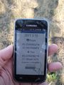
Just for proof :)
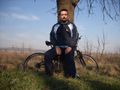
Me and the bike
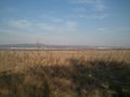
Varna as seen from the hash
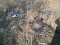
Some garbage on the field near the hash :(


Achievements
kisolre earned the Graticule Unlocked Achievement
|
kisolre earned the Bicycle geohash achievement
|