Difference between revisions of "2011-05-10 55 13"
From Geohashing
imported>Fasanen (An expedition message sent via Geohash Droid for Android.) |
imported>FippeBot m (Location) |
||
| (4 intermediate revisions by one other user not shown) | |||
| Line 1: | Line 1: | ||
| − | |||
| − | |||
| − | |||
| − | |||
| − | |||
| − | |||
| − | |||
| − | |||
| − | |||
| − | |||
{{meetup graticule | {{meetup graticule | ||
| lat=55 | | lat=55 | ||
| Line 15: | Line 5: | ||
}} | }} | ||
| − | |||
__NOTOC__ | __NOTOC__ | ||
== Location == | == Location == | ||
| − | + | At the edge of a field just outside Börringe, [[wikipedia:Skåne|Skåne]], [[wikipedia:Sweden|Sweden]]. | |
== Participants == | == Participants == | ||
| − | + | [[user:Fasanen|Fasanen]] | |
== Plans == | == Plans == | ||
| − | + | *Börringe station. Will check out that place tomorrow morning on the way to work. 06.30? -- [[User:Fasanen|Fasanen]] 16:37, 09 May 2011 (GMT+02:00) | |
== Expedition == | == Expedition == | ||
| − | + | It was a very fine and fresh morning when I stopped in Börringe to check out the geohash on my way to work in Lund. The grass was full of dew but I had packed my rubber boots and the walk was quite an easy one along a the edge of a newly sown field. I reached the hash after a few hundred meters without any crops being harmed. Photographic proof was taken in due order and I could continue my way to work without any particular events to report. | |
| − | == | + | *Success! -- [[User:Fasanen|Fasanen]] [http://www.openstreetmap.org/?lat=55.49563407897949&lon=13.33442509174347&zoom=16&layers=B000FTF @55.4956,13.3344] 06:40, 10 May 2011 (GMT+02:00) |
| − | |||
== Photos == | == Photos == | ||
| − | < | + | <gallery perrow="4"> |
| − | Image: | + | Image:201105105513 01.jpg |Börringe was the place to be |
| − | + | Image:201105105513 02.jpg |Walking to the hash | |
| − | + | Image:201105105513 03.jpg |Spruce buds | |
| + | Image:201105105513 04.jpg |Looking back towards Börringe | ||
| + | Image:201105105513 05.jpg |Proof | ||
| + | Image:201105105513 06.jpg |View from hash | ||
| + | Image:201105105513 07.jpg |View from hash | ||
| + | Image:201105105513 08.jpg |Immaculate job by the farmer | ||
</gallery> | </gallery> | ||
== Achievements == | == Achievements == | ||
{{#vardefine:ribbonwidth|800px}} | {{#vardefine:ribbonwidth|800px}} | ||
| − | + | {{land geohash | latitude=55 | longitude=13 | date=2011-05-10 | name=Fasanen}} | |
| − | |||
| − | |||
| − | |||
| − | |||
| − | |||
| − | |||
| − | |||
| − | |||
| − | |||
| − | |||
| − | |||
[[Category:Expeditions]] | [[Category:Expeditions]] | ||
| − | |||
[[Category:Expeditions with photos]] | [[Category:Expeditions with photos]] | ||
| − | |||
| − | |||
| − | |||
| − | |||
| − | |||
[[Category:Coordinates reached]] | [[Category:Coordinates reached]] | ||
| − | + | [[Category:Sweden]] | |
| − | + | {{location|SE|M}} | |
| − | |||
| − | [[Category: | ||
| − | |||
| − | |||
| − | |||
| − | |||
| − | |||
| − | |||
Latest revision as of 06:29, 9 August 2019
| Tue 10 May 2011 in 55,13: 55.4957903, 13.3347794 geohashing.info google osm bing/os kml crox |
Location
At the edge of a field just outside Börringe, Skåne, Sweden.
Participants
Plans
- Börringe station. Will check out that place tomorrow morning on the way to work. 06.30? -- Fasanen 16:37, 09 May 2011 (GMT+02:00)
Expedition
It was a very fine and fresh morning when I stopped in Börringe to check out the geohash on my way to work in Lund. The grass was full of dew but I had packed my rubber boots and the walk was quite an easy one along a the edge of a newly sown field. I reached the hash after a few hundred meters without any crops being harmed. Photographic proof was taken in due order and I could continue my way to work without any particular events to report.
- Success! -- Fasanen @55.4956,13.3344 06:40, 10 May 2011 (GMT+02:00)
Photos
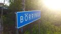
Börringe was the place to be
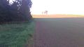
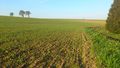
Walking to the hash
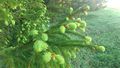
Spruce buds
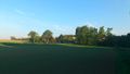
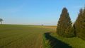
Looking back towards Börringe
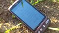
Proof
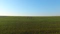
View from hash
View from hash
Immaculate job by the farmer


Achievements
Fasanen earned the Land geohash achievement
|