Difference between revisions of "2011-05-30 39 -77"
imported>TravisLow (→Photos) |
imported>FippeBot m (Location) |
||
| (4 intermediate revisions by 2 users not shown) | |||
| Line 1: | Line 1: | ||
| − | |||
| − | |||
| − | |||
| − | |||
| − | |||
| − | |||
| − | |||
| − | |||
| − | |||
{{meetup graticule | {{meetup graticule | ||
| lat=39 | | lat=39 | ||
| Line 16: | Line 7: | ||
}} | }} | ||
| − | + | ||
__NOTOC__ | __NOTOC__ | ||
== Location == | == Location == | ||
| − | + | Midway between Leesburg and Purcellville, on State Route 77. | |
== Participants == | == Participants == | ||
| − | + | ||
* [[User:TravisLow|Travis Low]] | * [[User:TravisLow|Travis Low]] | ||
| + | * Daughter | ||
== Plans == | == Plans == | ||
| − | + | ||
Between '''12 and 1pm''' -- Midway between Leesburg and Purcellville, on State Route 77. | Between '''12 and 1pm''' -- Midway between Leesburg and Purcellville, on State Route 77. | ||
| Line 39: | Line 31: | ||
As we were leaving, my daughter noticed the old "no trespassing" sign. Oops! | As we were leaving, my daughter noticed the old "no trespassing" sign. Oops! | ||
| − | |||
| − | |||
== Photos == | == Photos == | ||
| Line 54: | Line 44: | ||
</gallery> | </gallery> | ||
| − | |||
== Achievements == | == Achievements == | ||
| Line 60: | Line 49: | ||
<!-- Add any achievement ribbons you earned below, or remove this section --> | <!-- Add any achievement ribbons you earned below, or remove this section --> | ||
| + | * Land Geohash | ||
| − | |||
| − | |||
| − | |||
| − | |||
| − | |||
[[Category:Expeditions]] | [[Category:Expeditions]] | ||
| − | + | ||
| − | [[Category:Expeditions with photos]] | + | [[Category:Expeditions with photos]] |
| − | |||
| − | |||
| − | |||
| − | |||
| − | |||
[[Category:Coordinates reached]] | [[Category:Coordinates reached]] | ||
| − | + | {{location|US|VA|LD}} | |
| − | |||
| − | |||
| − | |||
| − | |||
| − | |||
| − | |||
| − | |||
| − | |||
| − | |||
Latest revision as of 06:43, 9 August 2019
| Mon 30 May 2011 in Frederick, Maryland: 39.1178768, -77.6393012 geohashing.info google osm bing/os kml crox |
Location
Midway between Leesburg and Purcellville, on State Route 77.
Participants
- Travis Low
- Daughter
Plans
Between 12 and 1pm -- Midway between Leesburg and Purcellville, on State Route 77.
Expedition
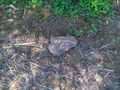
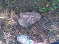
Arrived right on time! We went down this back road which got worse and worse, and finally an unpaved road -- VERY BUMPY. I recognized the area from the google satellite view. We got out of the car and walked through the marsh and ended up in the cornfield. I walked around with my GPS a while until I got as close as I could to the hashpoint and we put a rock there.
There was an old springhouse which was very cool (though my daughter was less impressed). It was the real thing, made of stone, sitting on a stream. Too bad it was totally collapsed or else I would have liked to go in.
Across the way was an old farmhouse with a tin roof. Not much else around. A few cars went by, which got our hopes up that we'd meet someone, but no dice. We waited the whole hour and then finally left.
As we were leaving, my daughter noticed the old "no trespassing" sign. Oops!
Photos
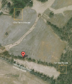
Satellite Image.
The exact hashpoint, near as we could figure. It was the middle of a cornfield lying fallow.
Rock with daughter's foot.

Rock with the entire daughter.
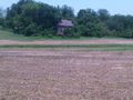
Old farm house with tin roof, probably abandoned (we didn't check)
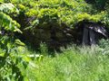
A spring house! Wow! Haven't seen one of those in years.
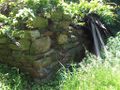
Closer view of spring house. We would have gone inside, but it had collapsed
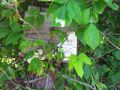
Oooops! Turns out we were trespassing. They really should maintain that sign better.


Achievements
- Land Geohash