Difference between revisions of "2011-07-03 39 -76"
From Geohashing
imported>1000miles1stStep (→Expedition) |
imported>FippeBot m (Location) |
||
| (19 intermediate revisions by 3 users not shown) | |||
| Line 1: | Line 1: | ||
| + | [[Image:IMAG0430.jpg|thumb|left]] | ||
| − | |||
| − | |||
| − | |||
| − | |||
| − | |||
| − | |||
| − | |||
| − | |||
| − | |||
{{meetup graticule | {{meetup graticule | ||
| lat=39 | | lat=39 | ||
| lon=-76 | | lon=-76 | ||
| date=2011-07-03 | | date=2011-07-03 | ||
| + | | image=IMAG0430.jpg | ||
}} | }} | ||
| − | + | ||
__NOTOC__ | __NOTOC__ | ||
== Location == | == Location == | ||
| Line 21: | Line 14: | ||
== Participants == | == Participants == | ||
| − | 1000miles1stStep | + | * [[User:1000miles1stStep|1000miles1stStep]] |
| − | |||
| − | |||
== Expedition == | == Expedition == | ||
| − | Route: B/W Parkway to MD Rt. 100. | + | Route: B/W Parkway to MD Rt. 100 East to Mountain Rd. to Freetown Rd. |
Mission accomplished at 7:08 PM. | Mission accomplished at 7:08 PM. | ||
| Line 35: | Line 26: | ||
Weather was thunderstormy. | Weather was thunderstormy. | ||
| − | == | + | == Photos == |
| − | |||
| − | |||
| − | |||
| − | |||
| − | |||
<gallery perrow="5"> | <gallery perrow="5"> | ||
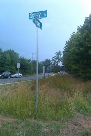
| + | Image:IMAG0430.jpg | The magic intersection | ||
| + | Image:HanzMassage.jpeg |Not sure who Hanz is, and not sure I want a massage from him! | ||
</gallery> | </gallery> | ||
== Achievements == | == Achievements == | ||
{{#vardefine:ribbonwidth|800px}} | {{#vardefine:ribbonwidth|800px}} | ||
| − | |||
| − | + | {{land geohash | |
| − | + | ||
| − | + | | latitude = 39 | |
| + | | longitude = -76 | ||
| + | | date = 2011-07-03 | ||
| + | | name = 1000miles1stStep | ||
| + | | image = IMAG0430.jpg | ||
| + | |||
| + | }} | ||
| + | |||
| + | {{A Tale of Two Hashes challenge | ||
| + | |||
| + | | latitude = 39 | ||
| + | | longitude = -76 | ||
| + | | date = 2011-07-03 | ||
| + | | name = 1000miles1stStep | ||
| + | | place = Freetown | ||
| + | | image = IMAG0430.jpg | ||
| + | |||
| + | }} | ||
| + | |||
| − | |||
| − | |||
| − | |||
| − | |||
| − | |||
[[Category:Expeditions]] | [[Category:Expeditions]] | ||
| − | |||
[[Category:Expeditions with photos]] | [[Category:Expeditions with photos]] | ||
| − | |||
| − | |||
| − | |||
| − | |||
| − | |||
[[Category:Coordinates reached]] | [[Category:Coordinates reached]] | ||
| − | + | {{location|US|MD|AN}} | |
| − | |||
| − | |||
| − | |||
| − | |||
| − | |||
| − | |||
| − | |||
| − | |||
| − | |||
Latest revision as of 06:58, 9 August 2019
| Sun 3 Jul 2011 in 39,-76: 39.1440572, -76.5689717 geohashing.info google osm bing/os kml crox |
Location
Freetown, MD
Participants
Expedition
Route: B/W Parkway to MD Rt. 100 East to Mountain Rd. to Freetown Rd.
Mission accomplished at 7:08 PM. Hash point was within a few meters of the street sign for the intersection of Solley Rd. and Freetown Rd.
Weather was thunderstormy.
Photos
Achievements
1000miles1stStep earned the Land geohash achievement
|
1000miles1stStep issued a challenge for the Tale of Two Hashes achievement
|


