Difference between revisions of "2011-10-19 51 -4"
imported>Homsar (argh why did I accidentally Command+W my window just as I was finishing up the gallery?) |
m (Location correction) |
||
| (5 intermediate revisions by 2 users not shown) | |||
| Line 1: | Line 1: | ||
| − | {{meetup graticule | + | [[Image:2011-10-19 51 -4 rhian swing.jpg|thumb|left]] |
| + | |||
| + | {{meetup graticule | ||
| lat=51 | | lat=51 | ||
| lon=-4 | | lon=-4 | ||
| date=2011-10-19 | | date=2011-10-19 | ||
| − | + | }} | |
| − | + | ||
| + | __NOTOC__ | ||
==Location== | ==Location== | ||
| Line 13: | Line 16: | ||
==Expedition== | ==Expedition== | ||
| − | ( | + | |
| + | I managed to recruit some friends on Facebook to come for this expedition. The problem with bringing friends is that they turn up late (and if one is there, you can't walk off without the rest without looking like a dick). So thanks to that and the bus being a minute early and not stopping, we missed the bus, and had to adjourn to the pub for desserts for an hour to wait for the next bus. | ||
| + | |||
| + | So with a somewhat delayed start, we set off down the footpath towards the hashpoint. Most of the footpath was sections of dried-up riverbed, and it was quite rocky, so walking was a bit slow (and more difficult on the legs than the average footpath). We discovered a cave at 51.578877, -4.058617 which we took a look inside; there was a substantial river running through it, but it was impassable without substantial caving/diving experience/training, none of which we had. So after some shining of torches around we moved on. | ||
| + | |||
| + | We overshot the hashpoint on the way out, but that did mean we got to find a rope swing over a river (where I managed to get my feet wet by not resisting the impulse to tuck my feet on the backswing) and a bridge, where we took a photo. Then we headed back to make sure we had time to reach the bus. | ||
| + | |||
| + | We hiked up the hill from the footpath through thorns and holly to reach the hashpoint, although we didn't manage to get the iPhone's dot to hit it, it did circle around it numerous times when we were stationary. After hiking back down and continuing to walk for a while, we noticed that we were at risk of missing the last bus for 90 minutes, so dashed back to the road (sadly missing a photo opportunity with a number plate mysteriously abandoned on the footpath), getting back a few minutes before the bus (which ended up being slightly late). Then back to the pub for dinner. | ||
==Gallery== | ==Gallery== | ||
| Line 34: | Line 44: | ||
[[Category:Expeditions with photos]] | [[Category:Expeditions with photos]] | ||
[[Category:Coordinates reached]] | [[Category:Coordinates reached]] | ||
| + | {{location|GB|CYM|ATA}} | ||
Latest revision as of 20:22, 22 May 2020
| Wed 19 Oct 2011 in 51,-4: 51.5778436, -4.0587934 geohashing.info google osm bing/os kml crox |
Location
Bishopston woods, Gower. Near Kittle, and adjacent to a footpath.
Participants
Homsar and friends
Expedition
I managed to recruit some friends on Facebook to come for this expedition. The problem with bringing friends is that they turn up late (and if one is there, you can't walk off without the rest without looking like a dick). So thanks to that and the bus being a minute early and not stopping, we missed the bus, and had to adjourn to the pub for desserts for an hour to wait for the next bus.
So with a somewhat delayed start, we set off down the footpath towards the hashpoint. Most of the footpath was sections of dried-up riverbed, and it was quite rocky, so walking was a bit slow (and more difficult on the legs than the average footpath). We discovered a cave at 51.578877, -4.058617 which we took a look inside; there was a substantial river running through it, but it was impassable without substantial caving/diving experience/training, none of which we had. So after some shining of torches around we moved on.
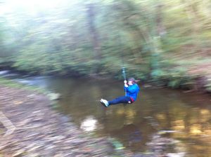
We overshot the hashpoint on the way out, but that did mean we got to find a rope swing over a river (where I managed to get my feet wet by not resisting the impulse to tuck my feet on the backswing) and a bridge, where we took a photo. Then we headed back to make sure we had time to reach the bus.
We hiked up the hill from the footpath through thorns and holly to reach the hashpoint, although we didn't manage to get the iPhone's dot to hit it, it did circle around it numerous times when we were stationary. After hiking back down and continuing to walk for a while, we noticed that we were at risk of missing the last bus for 90 minutes, so dashed back to the road (sadly missing a photo opportunity with a number plate mysteriously abandoned on the footpath), getting back a few minutes before the bus (which ended up being slightly late). Then back to the pub for dinner.
Gallery
Homsar on the swing
We discovered a spiral life form...


