Difference between revisions of "2013-05-22 43 -89"
imported>Swensonj (pictures!) |
imported>FippeBot m (Location) |
||
| (5 intermediate revisions by 2 users not shown) | |||
| Line 19: | Line 19: | ||
== Expedition == | == Expedition == | ||
| − | + | (This is the third in a string of consecutive geohashes: see [[2013-05-22_43_-89|previous]].) | |
| + | |||
| + | I had an errand to run in Madison this afternoon, and the [[43,-89]] hashpoint was extremely conveniently located, right along the highway, on a state trail. I got finished at work around 11:45 a.m. and set out on an expedition. (I forgot to turn off the tracklog when I got to the hash, so the whole trip, errands and all, is shown in the picture above. The hashpoint is where the track bumps north, near the middle.) | ||
| + | |||
| + | It was another overcast day, pleasant, but too cool and wet for shorts. I drove through a sprinkling of rain about 10 miles from the hash, but nothing was falling when I got to the parking place. I collected the necessary equipment and walked a short way up the Military Ridge State Trail. As I've mentioned, the GPS is getting touchy, and though I stomped around quite a bit, I couldn't get the proof photo to 5 decimal places of accuracy. It's safe to say, though, that I passed through the hash repeatedly. | ||
| + | |||
| + | Again, no one was around. I took some time to practice my only [[Circus Geohash]] skill, admired the scenery a bit, and then got on with my day. On the way out, I noticed the sign alerting me that one needs a pass to use the trail. I spent some time in Barneveld looking for a place to buy the pass, hoping to retroactively make things right and earn the coveted [[Admit One Geohash]] ribbon, but no one had any (correct) idea of where to get one. [The sign suggests that I check a bulletin board at a rest stop, of which there are none within 50 km.] Disappointing! | ||
== Photos == | == Photos == | ||
| Line 42: | Line 48: | ||
== Achievements == | == Achievements == | ||
{{#vardefine:ribbonwidth|800px}} | {{#vardefine:ribbonwidth|800px}} | ||
| − | <!-- | + | {{land geohash |
| − | + | | latitude = 43 | |
| + | | longitude = -89 | ||
| + | | date = 2013-05-22 | ||
| + | | name = [[User:Swensonj|SwensonJ]] | ||
| + | | image = 2013-05-22_43_-89_Proof.jpg | ||
| + | }} | ||
| + | {{Circus_geohash | ||
| + | | latitude = 43 | ||
| + | | longitude = -89 | ||
| + | | date = 2013-05-22 | ||
| + | | name = [[User:Swensonj|SwensonJ]] | ||
| + | | image = 2013-05-22_43_-89_Circus.jpg | ||
| + | | performance = juggling | ||
| + | }} | ||
| + | {{consecutive geohash 2 | ||
| + | | count = 3 | ||
| + | | latitude = 42 | ||
| + | | longitude = -90 | ||
| + | | date = 2013-05-20 | ||
| + | | name = [[User:Swensonj|SwensonJ]] | ||
| + | }} | ||
| + | <!-- According to http://jan.ucc.nau.edu/cvm-cgi-bin/latlongdist.pl | ||
| + | Distance between 43.0122519N 89.9546343W and 43.00874N 89.90121W is | ||
| + | 4.3662 km | ||
| + | --> | ||
| + | {{User:Swensonj/template/SquishyStars | ||
| + | | latitude = 43 | ||
| + | | longitude = -89 | ||
| + | | date = 2013-05-22 | ||
| + | | name = [[User:Swensonj|SwensonJ]] | ||
| + | | pointsnumber = 1 | ||
| + | | image = 2013-05-22_43_-89 Squishy.jpg | ||
| + | }} | ||
| + | {{Radio Yerevan | ||
| + | | achievement = Admit One geohash achievement | ||
| + | | detail = he couldn't figure out where to pay | ||
| + | | date = 2013-05-22 | ||
| + | | latitude = 43 | ||
| + | | longitude = -89 | ||
| + | | user = [[User:Swensonj|SwensonJ]] | ||
| + | | image = 2013-05-22_43_-89 Sign.jpg | ||
| + | }} | ||
| − | |||
[[Category:Expeditions]] | [[Category:Expeditions]] | ||
[[Category:Expeditions with photos]] | [[Category:Expeditions with photos]] | ||
[[Category:Coordinates reached]] | [[Category:Coordinates reached]] | ||
| + | {{location|US|WI|IO}} | ||
Latest revision as of 05:58, 6 August 2019
| Wed 22 May 2013 in 43,-89: 43.0122519, -89.9546343 geohashing.info google osm bing/os kml crox |
Location
Military Ridge State Trail, near Hwy 151 at Pikes Peak Road, west of Barneveld, Wisconsin.
Participants
Plans
I (SwensonJ) hope to hit this around lunchtime. Very accessible, and about as close to my house as you can be in 43,-89!
Expedition
(This is the third in a string of consecutive geohashes: see previous.)
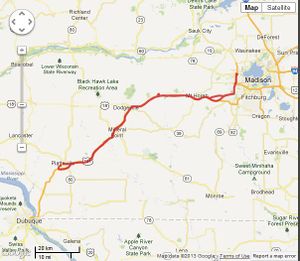
I had an errand to run in Madison this afternoon, and the 43,-89 hashpoint was extremely conveniently located, right along the highway, on a state trail. I got finished at work around 11:45 a.m. and set out on an expedition. (I forgot to turn off the tracklog when I got to the hash, so the whole trip, errands and all, is shown in the picture above. The hashpoint is where the track bumps north, near the middle.)
It was another overcast day, pleasant, but too cool and wet for shorts. I drove through a sprinkling of rain about 10 miles from the hash, but nothing was falling when I got to the parking place. I collected the necessary equipment and walked a short way up the Military Ridge State Trail. As I've mentioned, the GPS is getting touchy, and though I stomped around quite a bit, I couldn't get the proof photo to 5 decimal places of accuracy. It's safe to say, though, that I passed through the hash repeatedly.
Again, no one was around. I took some time to practice my only Circus Geohash skill, admired the scenery a bit, and then got on with my day. On the way out, I noticed the sign alerting me that one needs a pass to use the trail. I spent some time in Barneveld looking for a place to buy the pass, hoping to retroactively make things right and earn the coveted Admit One Geohash ribbon, but no one had any (correct) idea of where to get one. [The sign suggests that I check a bulletin board at a rest stop, of which there are none within 50 km.] Disappointing!
Photos
Achievements
SwensonJ earned the Land geohash achievement
|
SwensonJ earned the Circus Geohash Achievement
|
SwensonJ earned the Consecutive geohash achievement
|
SwensonJ earned 1 GeoSquishy star
|
Is it true that SwensonJ earned the Admit One geohash achievement?
|


