Difference between revisions of "2013-08-08 33 -117"
From Geohashing
imported>LucasBrown (City-levep map at hashpoint) |
imported>FippeBot m (Location) |
||
| (2 intermediate revisions by one other user not shown) | |||
| Line 1: | Line 1: | ||
| + | {{meetup graticule | lat=33 | lon=-117 | date=2013-08-08}} | ||
| − | |||
| − | |||
| − | |||
| − | |||
| − | |||
| − | |||
| − | |||
| − | |||
| − | |||
| − | |||
| − | |||
| − | |||
| − | |||
| − | |||
| − | |||
| − | |||
__NOTOC__ | __NOTOC__ | ||
== Location == | == Location == | ||
| − | + | In a fenced-in yard off Valladares Drive in Westwood, San Diego, CA | |
== Participants == | == Participants == | ||
| − | + | [[User:LucasBrown|LucasBrown]] | |
| − | |||
| − | |||
| − | |||
| − | |||
== Expedition == | == Expedition == | ||
| − | + | Reached the closest public approach (16 meters southwest) at 20:29 PDT. Knocked on the gate and introduced the man who answered to geohashing; he seemed rather pleasantly surprised about the whole thing. Didn't ask permission to get right on the hashpoint because it was already dark and that seemed rather creepy-stalkerish. | |
| − | |||
| − | |||
| − | |||
== Photos == | == Photos == | ||
| − | |||
| − | |||
| − | |||
<gallery perrow="5"> | <gallery perrow="5"> | ||
| − | |||
Image:2013-08-08_33_-117_21-05-04-312.jpg | Geohash Droid details page at hashpoint | Image:2013-08-08_33_-117_21-05-04-312.jpg | Geohash Droid details page at hashpoint | ||
| − | |||
Image:2013-08-08_33_-117_21-07-14-111.jpg | City-levep map at hashpoint | Image:2013-08-08_33_-117_21-07-14-111.jpg | City-levep map at hashpoint | ||
| + | Image:2013-08-08_33_-117_21-08-02-131.jpg | Street-level map at hashpoint | ||
</gallery> | </gallery> | ||
== Achievements == | == Achievements == | ||
{{#vardefine:ribbonwidth|800px}} | {{#vardefine:ribbonwidth|800px}} | ||
| − | + | {{Consecutive geohash | count = 2 | latitude = 32 | longitude = -117 | date = 2013-08-07 | name = LucasBrown}} | |
| − | |||
| − | |||
| − | |||
| − | |||
| − | |||
| − | |||
| − | |||
| − | |||
| − | |||
| − | |||
| − | |||
[[Category:Expeditions]] | [[Category:Expeditions]] | ||
| − | |||
[[Category:Expeditions with photos]] | [[Category:Expeditions with photos]] | ||
| − | |||
| − | |||
| − | |||
| − | |||
| − | |||
[[Category:Coordinates reached]] | [[Category:Coordinates reached]] | ||
| − | + | {{location|US|CA|SD}} | |
| − | |||
| − | |||
| − | |||
| − | |||
| − | |||
| − | |||
| − | |||
| − | |||
| − | |||
| − | |||
| − | |||
| − | |||
| − | |||
| − | |||
| − | |||
| − | |||
| − | |||
Latest revision as of 03:31, 14 August 2019
| Thu 8 Aug 2013 in 33,-117: 33.0351422, -117.0784656 geohashing.info google osm bing/os kml crox |
Location
In a fenced-in yard off Valladares Drive in Westwood, San Diego, CA
Participants
Expedition
Reached the closest public approach (16 meters southwest) at 20:29 PDT. Knocked on the gate and introduced the man who answered to geohashing; he seemed rather pleasantly surprised about the whole thing. Didn't ask permission to get right on the hashpoint because it was already dark and that seemed rather creepy-stalkerish.
Photos
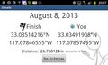
Geohash Droid details page at hashpoint
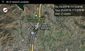
City-levep map at hashpoint
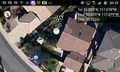
Street-level map at hashpoint


Achievements
LucasBrown earned the Consecutive geohash achievement
|