Difference between revisions of "2013-10-21 44 -123"
imported>Frogman (Created page with "{{subst:Expedition |lat = 44 |lon = -123 |date = 2013-10-21 }}") |
imported>FippeBot m (Location) |
||
| (12 intermediate revisions by 3 users not shown) | |||
| Line 15: | Line 15: | ||
}} | }} | ||
| − | + | ||
__NOTOC__ | __NOTOC__ | ||
== Location == | == Location == | ||
| − | + | ||
| + | In the middle of a forest in the Corvallis area near Witham Hill Natural Area. | ||
== Participants == | == Participants == | ||
| − | + | ||
| − | + | * [[User:Frogman|Frogman]] | |
| + | * [[User:Higgs|Higgs]] | ||
| + | * Callie | ||
| + | |||
| + | Alison and Greg came along for the trip but did not reach the hashpoint. | ||
== Plans == | == Plans == | ||
| − | + | ||
| + | After hitting the Peavy Arboretum hash the day before, I was hungry for more. Fortunately, this hash was well within walking distance! I invited a lot of friends and four agreed to come along. | ||
== Expedition == | == Expedition == | ||
| − | |||
| − | + | We left at about 6:15 from my house, which was probably too late to be wise (but hey, a geohasher's gotta geohash!). After a beautiful one-mile walk to the Witham Hill Natural Area we started down the trail, even though the sun was already setting. | |
| − | + | ||
| + | The Witham Hill Natural Area contains a lot of trails, many of which don't lead the direction we thought they would. At one junction we chose a trail which we began doubting. Alec, however, was pretty convinced that the trail would lead us to where we needed to go. "Have faith in my blind navigational skills!" said Alec, refusing to look at a GPS. Had he looked at a GPS, he would have seen that we were consistently moving away from the hashpoint. | ||
| + | |||
| + | After we retraced our steps, the sun was well set and we had to bring out our phones as flashlights. Eventually we had to leave the trail and romped through the forest. We were attacked from all angles by tree branches and invisible velociraptors (possibly they were blackberry bushes). After a while we came across a thicket. At this point I would have been willing to turn back, but Callie urged us to push onwards. "I speak loudly and carry a big stick!" she said, swinging with the aforementioned stick at the vines. Alec and I continued with her. | ||
| + | |||
| + | A very long 100 meters followed, but finally we came across the hashpoint. There was a bush there! We all put our hands over the bush in order to reach the hashpoint. | ||
| + | |||
| + | Our journey back was probably the most interesting bit of the expedition. Instead of hiking back up Witham Hill through the woods, we decided to cross some fields to get to nearby Walnut Blvd. These fields, although obviously unoccupied, were fenced off. The fences got increasingly higher and more difficult to cross, culminating in the final fence that blocked off the fields from the road. After a while of walking along this fence, we decided to try to cross it. It took us perhaps five minutes to get everyone across, but we made it! | ||
| + | |||
| + | After our trek home some of us went out to Qdoba. The food was acceptable. | ||
| + | |||
| + | |||
== Photos == | == Photos == | ||
| − | + | ||
| − | |||
| − | |||
<gallery perrow="5"> | <gallery perrow="5"> | ||
| + | Image:2013-10-21 44 -123 cat.jpg | Alison petting a cat! | ||
| + | Image:2013-10-21 44 -123 ontheway.jpg | On the way to the hash! | ||
| + | Image:2013-10-21 44 -123 parksign.jpg | A sign for the park. | ||
| + | Image:2013-10-21 44 -123 lostglasses.jpg | Someone lost their glasses. | ||
| + | Image:2013-10-21 44 -123 2dark.jpg | I tried to take a picture but then my phone ran out of battery. Following pictures from Alec's phone. | ||
| + | Image:2013-10-21 44 -123 grins1.jpg | Grins are hard in the dark. | ||
| + | Image:2013-10-21 44 -123 grins2.jpg | The flash hurts your eyes. | ||
| + | Image:2013-10-21 19-15-42.png | Proof! | ||
</gallery> | </gallery> | ||
== Achievements == | == Achievements == | ||
{{#vardefine:ribbonwidth|800px}} | {{#vardefine:ribbonwidth|800px}} | ||
| − | |||
| + | {{Walk geohash | ||
| + | | latitude = 44 | ||
| + | | longitude = -123 | ||
| + | | date = 2013-10-21 | ||
| + | | name = [[User:Frogman|Frogman]], [[User:Higgs|Higgs]], Callie, Greg, Alison | ||
| + | | distance = 3.7 miles | ||
| + | | image = 2013-10-21 44 -123 ontheway.jpg | ||
| + | }} | ||
| + | {{Hashcat | ||
| + | | latitude = 44 | ||
| + | | longitude = -123 | ||
| + | | date = 2013-10-21 | ||
| + | | name = [[User:Frogman|Frogman]], Alison | ||
| + | | image = 2013-10-21 44 -123 cat.jpg | ||
| + | }} | ||
| + | {{drag-along | ||
| + | | latitude = 44 | ||
| + | | longitude = -123 | ||
| + | | date = 2013-10-21 | ||
| + | | partner = [[User:Higgs|Higgs]], Greg, Callie | ||
| + | | name = [[User:Higgs|Higgs]], [[User:Frogman|Frogman]] | ||
| + | }} | ||
| − | |||
| − | |||
| − | |||
| − | |||
| − | |||
| − | |||
| − | |||
| − | |||
| − | |||
| − | |||
[[Category:Expeditions]] | [[Category:Expeditions]] | ||
| − | |||
[[Category:Expeditions with photos]] | [[Category:Expeditions with photos]] | ||
| − | |||
| − | |||
| − | |||
| − | |||
[[Category:Coordinates reached]] | [[Category:Coordinates reached]] | ||
| − | + | {{location|US|OR|BE}} | |
| − | |||
| − | |||
| − | |||
| − | |||
| − | |||
| − | |||
| − | |||
| − | |||
| − | |||
| − | |||
| − | |||
| − | |||
| − | |||
| − | |||
| − | |||
| − | |||
| − | |||
Latest revision as of 04:24, 14 August 2019
| Mon 21 Oct 2013 in 44,-123: 44.5792184, -123.3062221 geohashing.info google osm bing/os kml crox |
Location
In the middle of a forest in the Corvallis area near Witham Hill Natural Area.
Participants
Alison and Greg came along for the trip but did not reach the hashpoint.
Plans
After hitting the Peavy Arboretum hash the day before, I was hungry for more. Fortunately, this hash was well within walking distance! I invited a lot of friends and four agreed to come along.
Expedition
We left at about 6:15 from my house, which was probably too late to be wise (but hey, a geohasher's gotta geohash!). After a beautiful one-mile walk to the Witham Hill Natural Area we started down the trail, even though the sun was already setting.
The Witham Hill Natural Area contains a lot of trails, many of which don't lead the direction we thought they would. At one junction we chose a trail which we began doubting. Alec, however, was pretty convinced that the trail would lead us to where we needed to go. "Have faith in my blind navigational skills!" said Alec, refusing to look at a GPS. Had he looked at a GPS, he would have seen that we were consistently moving away from the hashpoint.
After we retraced our steps, the sun was well set and we had to bring out our phones as flashlights. Eventually we had to leave the trail and romped through the forest. We were attacked from all angles by tree branches and invisible velociraptors (possibly they were blackberry bushes). After a while we came across a thicket. At this point I would have been willing to turn back, but Callie urged us to push onwards. "I speak loudly and carry a big stick!" she said, swinging with the aforementioned stick at the vines. Alec and I continued with her.
A very long 100 meters followed, but finally we came across the hashpoint. There was a bush there! We all put our hands over the bush in order to reach the hashpoint.
Our journey back was probably the most interesting bit of the expedition. Instead of hiking back up Witham Hill through the woods, we decided to cross some fields to get to nearby Walnut Blvd. These fields, although obviously unoccupied, were fenced off. The fences got increasingly higher and more difficult to cross, culminating in the final fence that blocked off the fields from the road. After a while of walking along this fence, we decided to try to cross it. It took us perhaps five minutes to get everyone across, but we made it!
After our trek home some of us went out to Qdoba. The food was acceptable.
Photos
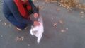
Alison petting a cat!

On the way to the hash!
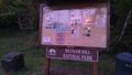
A sign for the park.
Someone lost their glasses.
I tried to take a picture but then my phone ran out of battery. Following pictures from Alec's phone.
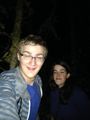
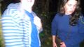
Grins are hard in the dark.
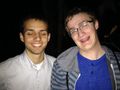
The flash hurts your eyes.
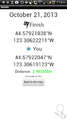
Proof!


Achievements
Frogman, Higgs, Callie, Greg, Alison earned the Walk geohash Achievement
|
Frogman, Alison earned the Hashcat achievement
|
Higgs, Frogman earned the Drag-along achievement
|