Difference between revisions of "2013-12-25 35 -119"
imported>Bravissimo594 (No bunnies to play with. :-( [http://www.openstreetmap.org/?lat=35.06950000&lon=-119.08400000&zoom=16&layers=B000FTF @35.0695,-119.0840]) |
m (per Renaming Proposal) |
||
| (11 intermediate revisions by 2 users not shown) | |||
| Line 1: | Line 1: | ||
<!-- If you did not specify these parameters in the template, please substitute appropriate values for IMAGE, LAT, LON, and DATE (YYYY-MM-DD format) | <!-- If you did not specify these parameters in the template, please substitute appropriate values for IMAGE, LAT, LON, and DATE (YYYY-MM-DD format) | ||
| − | + | --> | |
| − | [[Image:{{{image| | + | [[Image:{{{image|2013-12-25_35_-119_12-25-53-417.jpg}}}|thumb|left]] |
| − | + | <!-- | |
Remove this section if you don't want an image at the top (left) of your report. You should remove the "Image:" or "File:" | Remove this section if you don't want an image at the top (left) of your report. You should remove the "Image:" or "File:" | ||
tag from your image file name, and replace the all upper-case word IMAGE in the above line. | tag from your image file name, and replace the all upper-case word IMAGE in the above line. | ||
| Line 19: | Line 19: | ||
== Location == | == Location == | ||
<!-- where you've surveyed the hash to be --> | <!-- where you've surveyed the hash to be --> | ||
| − | An agricultural field east of Maricopa, CA, near State Route 166 and | + | An agricultural field east of Maricopa, CA, near State Route 166 and not too far from Interstate 5. [[Bakersfield,_California|Bakersfield]] graticule. |
== Participants == | == Participants == | ||
| Line 29: | Line 29: | ||
== Plans == | == Plans == | ||
<!-- what were the original plans --> | <!-- what were the original plans --> | ||
| − | We will drive up from the [[Los_Angeles,_California|Los Angeles, California]], graticule and see if the farm roads are accessible. The dogs might get to play with any hares they find around there too. I expect to arrive sometime around 11:00am and stay until about 11:30. Then | + | We will drive up from the [[Los_Angeles,_California|Los Angeles, California]], graticule and see if the farm roads are accessible. The dogs might get to play with any hares they find around there too. I expect to arrive sometime around 11:00am and stay until about 11:30. Then we will try to hit the [[Tehachapi,_California|Tehachapi]] [[2013-12-25_35_-118|meetup point]] a couple of hours later, possibly with a lunch stop along the way. |
If things go ''really'' smoothly, the [[Ridgecrest,_California|Ridgecrest]] [[2013-12-25_35_-117|meetup point]] might be within reach too. But that would be an ambitious Christmas day. | If things go ''really'' smoothly, the [[Ridgecrest,_California|Ridgecrest]] [[2013-12-25_35_-117|meetup point]] might be within reach too. But that would be an ambitious Christmas day. | ||
| Line 35: | Line 35: | ||
== Expedition == | == Expedition == | ||
<!-- how it all turned out. your narrative goes here. --> | <!-- how it all turned out. your narrative goes here. --> | ||
| + | === [[User:Bravissimo594|Bravissimo594]] === | ||
| + | After a nice Christmas-morning sleep-in, [[User:Boppy5|Boppy5]] and I finally made it on the road shortly after 10:00am. Fueling up at a nearby gas station and ATM, we drove up Interstate 5, exited at State Route 166, and traveled west for a short time. Satellite imagery on Google Maps showed the meetup point to be near the edge of a plowed field. I hoped that the image was not so old that the field would be full of crops. | ||
| − | + | We turned north on a farm road near the destination and noticed no-trespassing signs banning entry to orange groves beside the road. At this point, I was really hopeful that the field was still plowed and not barred from entry. Fortunately, everything matched the satellite images, so we were able to hike a short way out into the field (which had nothing at all planted in it) and make the meetup point. | |
| − | + | ||
| + | The dogs got a chance to paw around in the soft ground and even sniffed a nearby vineyard but found no hares to play with. | ||
== Photos == | == Photos == | ||
| Line 57: | Line 60: | ||
{{#vardefine:ribbonwidth|800px}} | {{#vardefine:ribbonwidth|800px}} | ||
<!-- Add any achievement ribbons you earned below, or remove this section --> | <!-- Add any achievement ribbons you earned below, or remove this section --> | ||
| + | |||
| + | {{land geohash | ||
| + | | latitude = 35 | ||
| + | | longitude = -119 | ||
| + | | date = 2013-12-25 | ||
| + | | name = Boppy5 and Bravissimo594 | ||
| + | | image = 2013-12-25_35_-119_12-21-54-348.jpg | ||
| + | |||
| + | }} | ||
| + | |||
| + | {{Graticule unlocked | ||
| + | | latitude = 35 | ||
| + | | longitude = -119 | ||
| + | | date = 2013-12-25 | ||
| + | | name = Boppy5 and Bravissimo594 | ||
| + | | image = 2013-12-25_35_-119_12-21-54-348.jpg | ||
| + | |||
| + | }} | ||
<!-- =============== USEFUL CATEGORIES FOLLOW ================ | <!-- =============== USEFUL CATEGORIES FOLLOW ================ | ||
Delete the next line ONLY if you have chosen the appropriate categories below. If you are unsure, don't worry. People will read your report and help you with the classification. --> | Delete the next line ONLY if you have chosen the appropriate categories below. If you are unsure, don't worry. People will read your report and help you with the classification. --> | ||
| − | |||
| − | |||
| − | |||
| − | |||
| − | |||
| − | |||
| − | |||
[[Category:Expeditions]] | [[Category:Expeditions]] | ||
| − | |||
[[Category:Expeditions with photos]] | [[Category:Expeditions with photos]] | ||
| − | |||
| − | |||
| − | |||
| − | |||
[[Category:Coordinates reached]] | [[Category:Coordinates reached]] | ||
| − | + | {{location|US|CA|KE}} | |
| − | |||
| − | |||
| − | |||
| − | |||
| − | |||
| − | |||
| − | |||
| − | |||
| − | |||
| − | |||
| − | |||
| − | |||
| − | |||
| − | |||
| − | |||
| − | |||
| − | |||
Latest revision as of 05:16, 20 March 2024

| Wed 25 Dec 2013 in 35,-119: 35.0694823, -119.0841345 geohashing.info google osm bing/os kml crox |
Location
An agricultural field east of Maricopa, CA, near State Route 166 and not too far from Interstate 5. Bakersfield graticule.
Participants
Plans
We will drive up from the Los Angeles, California, graticule and see if the farm roads are accessible. The dogs might get to play with any hares they find around there too. I expect to arrive sometime around 11:00am and stay until about 11:30. Then we will try to hit the Tehachapi meetup point a couple of hours later, possibly with a lunch stop along the way.
If things go really smoothly, the Ridgecrest meetup point might be within reach too. But that would be an ambitious Christmas day.
Expedition
Bravissimo594
After a nice Christmas-morning sleep-in, Boppy5 and I finally made it on the road shortly after 10:00am. Fueling up at a nearby gas station and ATM, we drove up Interstate 5, exited at State Route 166, and traveled west for a short time. Satellite imagery on Google Maps showed the meetup point to be near the edge of a plowed field. I hoped that the image was not so old that the field would be full of crops.
We turned north on a farm road near the destination and noticed no-trespassing signs banning entry to orange groves beside the road. At this point, I was really hopeful that the field was still plowed and not barred from entry. Fortunately, everything matched the satellite images, so we were able to hike a short way out into the field (which had nothing at all planted in it) and make the meetup point.
The dogs got a chance to paw around in the soft ground and even sniffed a nearby vineyard but found no hares to play with.
Photos
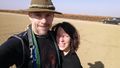
On the spot in an open field. @35.0695,-119.0840
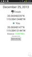
Geohash Droid at the spot.
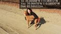
Boppy5 and Tosca nearby. @35.0697,-119.0850
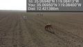
No bunnies to play with. :-( @35.0695,-119.0840


Achievements
Boppy5 and Bravissimo594 earned the Land geohash achievement
|
Boppy5 and Bravissimo594 earned the Graticule Unlocked Achievement
|