Difference between revisions of "2014-12-22 46 -119"
imported>Thomcat (Page creation and expedition report) |
imported>FippeBot m (Location) |
||
| (2 intermediate revisions by one other user not shown) | |||
| Line 43: | Line 43: | ||
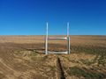
Image:2014-12-22_46_-119_SprinklerBumper.jpg | Image:2014-12-22_46_-119_SprinklerBumper.jpg | ||
| + | |||
| + | Image:2014-12-22_46_-119_thomcat_1419356126524.jpg | Screenshot test | ||
| + | |||
| + | Image:2014-12-22_46_-119_thomcat_1420493557102.jpg | [http://www.openstreetmap.org/?lat=47.08313737&lon=-119.85990675&zoom=16&layers=B000FTF @47.0831,-119.8599] | ||
</gallery> | </gallery> | ||
| Line 52: | Line 56: | ||
[[Category:Expeditions with photos]] | [[Category:Expeditions with photos]] | ||
[[Category:Coordinates reached]] | [[Category:Coordinates reached]] | ||
| + | {{location|US|WA|GN}} | ||
Latest revision as of 02:14, 15 August 2019
| Mon 22 Dec 2014 in Tri Cities: 46.9899658, -119.8548975 geohashing.info google osm bing/os kml crox |
Location
Just south of George, in the Frenchman Hills
Participants
Expedition
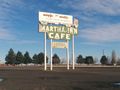
George, Washington, is right in the middle of the state along the main highway between Spokane and Seattle. When I was younger, the bus trip between the two cites would stop there for a lunch or dinner stop, depending on the time of the run. Where would it stop? Well at the Martha Inn Cafe, of course.
I don't think it was really an Inn, at least in the common sense of the word. And for certain it isn't there anymore - it closed in 2006 and the dilapidated building (and fire hazard) was removed in 2010. Only the foundation (and likely a few geocaches) remain. After driving 143 miles (230 km) from Spokane Valley, I found that I had no internet service and only spotty cellular coverage, so I gave up on Geohashdroid and moved on towards the hashpoint.
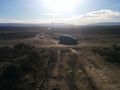
The Toyota GPS told me to drive straight south, up and over a hill. Through a plowed field, apparently - no road was to be seen. Instead I reverted to what my research indicated was a close approach on Beverly Burke road. Indeed a side road led off towards the hash point, reaching the farmers field from the south. I parked the car, uttering the standard line "We walk from here".
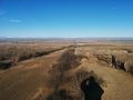
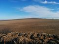
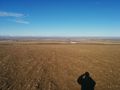
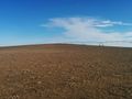
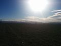
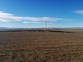
Hiking south up to the top of the bluff brought me nearly directly west of the geohashpoint. I snapped a quick photo of downtown George from the hillside and hiked east. This field was harvested in recent months, leaving only partial stocks above the ground. A quick dance at the hashpoint led me to near zero conditions - and again, I couldn't connect through geohashdroid. With no other camera to snap a picture of the screen, I settled for cardinal photos. (Come to think of it, there *must* be an Android screen capture...)
This was only the third expedition to this graticule, and the second successful. The previous success (also mine) was diametrically opposite, south of the Tri Cities. Satisfied, I resumed my drive to Seattle, where I hope to find a decent geohash before Christmas.
Photos


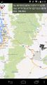
Screenshot test


