Difference between revisions of "2015-01-28 49 8"
imported>Q-Owl (→Achievements / Honorable Mention) |
imported>FippeBot m (Location) |
||
| (2 intermediate revisions by one other user not shown) | |||
| Line 95: | Line 95: | ||
| image = 2015-01-28 49 8 vr.jpg | | image = 2015-01-28 49 8 vr.jpg | ||
}} | }} | ||
| + | |||
{{xkcd-100-Honorable-Mention | {{xkcd-100-Honorable-Mention | ||
| Line 104: | Line 105: | ||
}} | }} | ||
| − | == | + | |
| + | == Useful Links == | ||
| + | |||
[http://geo.crox.net/poster/{{FULLPAGENAME}} Poster for this expedition] | [http://geo.crox.net/poster/{{FULLPAGENAME}} Poster for this expedition] | ||
| Line 111: | Line 114: | ||
[[Category:Expeditions with photos]] | [[Category:Expeditions with photos]] | ||
[[Category:Expeditions]] | [[Category:Expeditions]] | ||
| + | {{location|FR|67}} | ||
Latest revision as of 02:34, 15 August 2019
| Wed 28 Jan 2015 in 49,8: 49.0155413, 8.0065195 geohashing.info google osm bing/os kml crox |
Location
In the little French part (northern Alsace) of the Mannheim graticule.
The hashpoint is located in the forest near the D3 road leading from Lauterbourg to Wissembourg, about 4.5 km east of the center (railway station) of Wissembourg.
Participants
Plan
May be I'll take a day off, if my chef allows it. I plan to drive to the hashpoint in the morning. Reach it, visit N 49° 00,000' E 8° 00,000' and find a few geocaches.
Possible activities nearby:
Confluencing by visiting N 49° 00,000' E 8° 00,000' (1.8 km ssw, near the D244)
Nearest Geocaches: GC24NAR and GC52QB3
Safari Cache: OCF495 (0.0 km^^)
Expedition
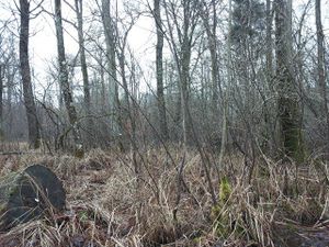
I took about 4 hours off, drove the B9 from Ludwigshafen to Wörth, crossed the D/F border at Lauterbourg and parked the car at the D3 about 0.5 km NE to the hashpoint. Then I put on boots, got the bicycle out of the car and drove on wet forest roads near the hashpoint. I reached it in a swampy area of the huge forest "Bienwald".
Very good, that I wore my rain boots, because I had to "dance" about 10 to 15 minutes under clouds and trees and between blackberry tendrills in the swamp. After this I marked the hashpoint with a little white piece of paper, took some photos and drove back to the car.
On my way back to the German border I visited the degree confluence N 49° 00,000' E 8° 00,000' and the "Mirrorpoint" N 49° 00,080' E 08° 00,094' (Safari Cache: OC01B0) and I found 6 geocaches (geocaching.com).
- - - - - - - - - - - - - -
240 km by car, 1.7 km on bicycle and about 150 m walk:
Does geohashing seem a little bit crazy?
Yes, it is a little bit crazy! ;-)
But it is a lot of fun!! :-)
Photos
Achievements / Honorable Mention
Q-Owl earned the Land geohash achievement
|
Q-Owl earned the Border geohash achievement
|
Q-Owl earned the Reverse regional achievement
|
Q-Owl earned the Reverse regional achievement
|
Q-Owl earned the Velociraptor Geohash Achievement
|
Q-Owl earned the XKCD-100 Honorable Mention Achievement
|


