Difference between revisions of "2015-06-03 52 1"
From Geohashing
imported>Sourcerer (→Planning) |
imported>FippeBot m (Location) |
||
| (10 intermediate revisions by one other user not shown) | |||
| Line 3: | Line 3: | ||
| lon=1 | | lon=1 | ||
| date=2015-06-03 | | date=2015-06-03 | ||
| + | | graticule_name=Norwich, UK | ||
| + | | graticule_link=Norwich, United Kingdom | ||
}} | }} | ||
__NOTOC__ | __NOTOC__ | ||
| Line 15: | Line 17: | ||
== Plans == | == Plans == | ||
| − | + | Expedition one of two spanning midnight. ETA 23:00 - [[2015-06-03 52 1]] - [[2015-06-04 52 1]] | |
== Expedition == | == Expedition == | ||
| + | The farm access road was also a public footpath. | ||
| + | On the outward journey, there was a spectacular rising moon, nearly full. | ||
| + | |||
| + | *Arrived. -- [[User:Sourcerer|Sourcerer]] ([[User talk:Sourcerer|talk]]) [http://www.openstreetmap.org/?lat=52.15181716&lon=1.36877282&zoom=16&layers=B000FTF @52.1518,1.3688] 22:43, 3 June 2015 (GMT+01:00) | ||
| + | |||
| + | This was easy, arriving 15 minutes earlier than planned. The hashpoint was a few paces from the parking place in a field entrance. I got the evidence photos and set out for the next hashpoint with time to spare. | ||
== Photos == | == Photos == | ||
<gallery perrow="5"> | <gallery perrow="5"> | ||
| − | + | Image:2015-06-03_52_1_Sourcerer_1433367676193.jpg | Proof. [http://www.openstreetmap.org/?lat=52.15255558&lon=1.38849378&zoom=16&layers=B000FTF @52.1526,1.3885] | |
| + | Image:2015-06-03_52_1_Sourcerer_1433367707711.jpg | Farm Sign. [http://www.openstreetmap.org/?lat=52.15255022&lon=1.38849378&zoom=16&layers=B000FTF @52.1526,1.3885] | ||
</gallery> | </gallery> | ||
| Line 30: | Line 39: | ||
{{#vardefine:ribbonwidth|800px}} | {{#vardefine:ribbonwidth|800px}} | ||
| + | {{Sourcerer_links | ||
| + | | prev = 2015-06-02 52 1 | ||
| + | | curr = 2015-06-03 52 1 | ||
| + | | next = 2015-06-04 52 1 | ||
| + | | date = 2015-06-03 | ||
| + | }} | ||
| − | |||
| − | |||
| − | |||
| − | |||
| − | |||
| − | |||
[[Category:Expeditions]] | [[Category:Expeditions]] | ||
[[Category:Expeditions with photos]] | [[Category:Expeditions with photos]] | ||
[[Category:Coordinates reached]] | [[Category:Coordinates reached]] | ||
| − | + | {{location|GB|ENG|SFK}} | |
Latest revision as of 03:54, 15 August 2019
| Wed 3 Jun 2015 in Norwich, UK: 52.1525477, 1.3884927 geohashing.info google osm bing/os kml crox |
Location
A farm entrance between Wickham Market town and the railway station, Suffolk, UK.
Participants
Plans
Expedition one of two spanning midnight. ETA 23:00 - 2015-06-03 52 1 - 2015-06-04 52 1
Expedition
The farm access road was also a public footpath.
On the outward journey, there was a spectacular rising moon, nearly full.
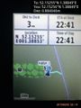
- Arrived. -- Sourcerer (talk) @52.1518,1.3688 22:43, 3 June 2015 (GMT+01:00)
This was easy, arriving 15 minutes earlier than planned. The hashpoint was a few paces from the parking place in a field entrance. I got the evidence photos and set out for the next hashpoint with time to spare.
Photos
Proof. @52.1526,1.3885

Farm Sign. @52.1526,1.3885


Achievements
Expeditions and Plans
| 2015-06-03 | ||
|---|---|---|
| Rochester, New York | Pedalpusher | Near Bergen, just East of Exit 2 for I-490 on Chili Riga Center Rd. |
| Lockport, New York | Pedalpusher | On Liberty Rd by Ceres Electronics Corp. |
| Wien, Austria | Crankl, B2c, Micsnare | was located in directly in Vienna's 10th district. |
| Mannheim, Germany | RecentlyChanged | A quarry pond. |
| Kraków, Poland | Malgond | On the A4 motorway! Tally-ho! The legal speed is 140 km/h. |
| Halle (Saale), Germany | Reinhard | On a field, North of Mannstedt, Thuringia, Germany. |
| Norwich, United Kingdom | Sourcerer | A farm entrance between Wickham Market town and the railway station, Suffol... |
| Utrecht, Netherlands | Someone went | Right in the city center of Amersfoort, exactly on the location of the (par... |
Sourcerer's Expedition Links
2015-06-02 52 1 - 2015-06-03 52 1 - 2015-06-04 52 1 - KML file download of Sourcerer's expeditions for use with Google Earth.