Difference between revisions of "2015-12-14 52 1"
imported>Sourcerer m ([retro picture] Proof. [http://www.openstreetmap.org/?lat=52.80166090&lon=1.36685908&zoom=16&layers=B000FTF @52.8017,1.3669]) |
imported>FippeBot m (Location) |
||
| (2 intermediate revisions by one other user not shown) | |||
| Line 18: | Line 18: | ||
== Plans == | == Plans == | ||
| − | Expedition | + | Expedition three of three spanning midnight - [[2015-12-13 52 1]] - [[2013-09-22 52 1|2013-09-22 52 1 Retro]] - [[2015-12-14 52 1]] - ETA 00:00. |
== Expedition == | == Expedition == | ||
| + | *Arrived. -- [[User:Sourcerer|Sourcerer]] ([[User talk:Sourcerer|talk]]) [http://www.openstreetmap.org/?lat=52.80165553&lon=1.36685908&zoom=16&layers=B000FTF @52.8017,1.3669] 00:01, 14 December 2015 (GMT) | ||
| + | This was a good one. Recently there has been a lot of foul weather with gales and driving rain. Tonight was dry and still but the ground was very wet in places. Public footpaths led through wheat stubble, sweet corn and finally sugar beet. A stile led to the woodland path. The hashpoint was a few paces off the path. There were many mature trees of great stature. I did not move between my two evidence shots which were taken about a minute apart. This GPS drift is very common. | ||
| − | |||
| − | |||
== Photos == | == Photos == | ||
<gallery> | <gallery> | ||
| − | |||
Image:2015-12-14_52_1_Sourcerer_1450051201258.jpg | Proof. [http://www.openstreetmap.org/?lat=52.80166090&lon=1.36685908&zoom=16&layers=B000FTF @52.8017,1.3669] | Image:2015-12-14_52_1_Sourcerer_1450051201258.jpg | Proof. [http://www.openstreetmap.org/?lat=52.80166090&lon=1.36685908&zoom=16&layers=B000FTF @52.8017,1.3669] | ||
| + | Image:2015-12-14_52_1_Sourcerer_1450051244575.jpg | Drift. [http://www.openstreetmap.org/?lat=52.80165553&lon=1.36685908&zoom=16&layers=B000FTF @52.8017,1.3669] | ||
| + | Image:2015-12-14 52 1 Sourcerer.jpg | Track in Google Earth | ||
</gallery> | </gallery> | ||
== Achievements == | == Achievements == | ||
{{#vardefine:ribbonwidth|700px}} | {{#vardefine:ribbonwidth|700px}} | ||
| + | |||
| + | {{Midnight geohash | ||
| + | | latitude = 52 | ||
| + | | longitude = 1 | ||
| + | | date = 2015-12-14 | ||
| + | | name = Sourcerer | ||
| + | }} | ||
{{Sourcerer_links | {{Sourcerer_links | ||
| Line 42: | Line 50: | ||
}} | }} | ||
| − | |||
| − | |||
[[Category:Expeditions]] | [[Category:Expeditions]] | ||
[[Category:Expeditions with photos]] | [[Category:Expeditions with photos]] | ||
[[Category:Coordinates reached]] | [[Category:Coordinates reached]] | ||
| − | + | {{location|GB|ENG|NFK}} | |
Latest revision as of 06:08, 15 August 2019
| Mon 14 Dec 2015 in Norwich, UK: 52.8016388, 1.3668125 geohashing.info google osm bing/os kml crox |
Location
This looks as though it's on or close to a woodland path between Lord Anson's Wood and Perch Lake Plantation. This is south west of North Walsham, Norfolk, UK.
Participants
Plans
Expedition three of three spanning midnight - 2015-12-13 52 1 - 2013-09-22 52 1 Retro - 2015-12-14 52 1 - ETA 00:00.
Expedition
- Arrived. -- Sourcerer (talk) @52.8017,1.3669 00:01, 14 December 2015 (GMT)
This was a good one. Recently there has been a lot of foul weather with gales and driving rain. Tonight was dry and still but the ground was very wet in places. Public footpaths led through wheat stubble, sweet corn and finally sugar beet. A stile led to the woodland path. The hashpoint was a few paces off the path. There were many mature trees of great stature. I did not move between my two evidence shots which were taken about a minute apart. This GPS drift is very common.
Photos
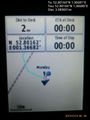
Proof. @52.8017,1.3669
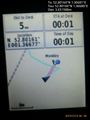
Drift. @52.8017,1.3669
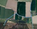
Track in Google Earth


Achievements
Sourcerer earned the Midnight Geohash achievement
|
Expeditions and Plans
| 2015-12-14 | ||
|---|---|---|
| Bonn, Germany | Burgman | After the slightly disappointing geohash 2015-12-11_50_7 last Friday, I saw the chance for... |
| Norwich, United Kingdom | Sourcerer | This looks as though it's on or close to a woodland path between Lord Anson... |
Sourcerer's Expedition Links
2015-12-13 52 1 - 2015-12-14 52 1 - 2015-12-15 52 1 - KML file download of Sourcerer's expeditions for use with Google Earth.