Difference between revisions of "2016-06-09 60 24"
imported>PPP (Created page with "{{meetup graticule | lat=60 | lon=24 | date=2016-06-09 }} __NOTOC__ == Location == In the West-Pasila. Easily reachable by public trafic - - - Länsi-Pasilassa hyvien liik...") |
m |
||
| (6 intermediate revisions by 3 users not shown) | |||
| Line 7: | Line 7: | ||
__NOTOC__ | __NOTOC__ | ||
== Location == | == Location == | ||
| − | In the West-Pasila. | + | In the West-Pasila [http://kansalaisen.karttapaikka.fi/kartanhaku/osoitehaku.html?e=384625&n=6676406&scale=4000&tool=siirra&width=990&height=570&showSRS=EPSG:4258&mode=rasta&lang=en], easily reachable by public trafic |
- - - | - - - | ||
| Line 17: | Line 17: | ||
== Plans == | == Plans == | ||
| − | I'll try wishfully find time to visit there @ Lunchtime / PPP | + | I'll try wishfully find time to visit there @ Lunchtime. / [[User:PPP|PPP]] |
- - - - | - - - - | ||
| − | Lounasaikaan saattaisi ehtiä jos jättää syömättä tai ahmii. / PPP | + | Lounasaikaan saattaisi ehtiä jos jättää syömättä tai ahmii. / [[User:PPP|PPP]] |
| + | |||
| + | [[User:Tilley|Tilley]]'s plans: Will attempt this today, but I can only make it after work, around 18 pm. That's probably too late for you, PPP? | ||
== Participants == | == Participants == | ||
| − | + | Expedition 2(?): [[User:Tilley|Tilley]] | |
== Expedition == | == Expedition == | ||
| − | - - - - | + | Tilley's expedition: |
| + | |||
| + | [[File:2016-06-09_60_24_WP_20160609_18_37_27_Pro.jpg|thumb|left|250px|Raptor attack evidence!]] | ||
| + | I set out after work about 17:50. On the way I couldn't resist the nice forest trails and cliffs in the Central Park of Helsinki and I circled around a bit to tackle those. And there were raptors, too, lurking in the forest, only 200 meters from the hashpoint! They ambushed me and I barely managed to escape with some wounds. See pictures for proof. | ||
| + | |||
| + | [[File:2016-06-09_60_24_WP_20160609_18_42_35_Pro.jpg|thumb|right|300px|This time the grin is really grim.]] | ||
| + | The hashpoint was found easily. It was on a steep slope of grass, built there for the purpose of the elevated road. My GPS pinpointed me to almost to the top of the slope, although Google Maps suggests that the point would have been on the bottom of the slope. Actually you can see that in my "grin of agony" -picture GPS shows 19 meters to the point, although the previous GPS close-up shot of 1 m was taken at the exactly same spot. Nevertheless, the point was definitely reached, because I climbed the slope from the bottom to the top. I took some photos and continued to my place of stay in Leppävaara to tend to my wounds. | ||
== Weather & Sky == | == Weather & Sky == | ||
| + | Cloudy, windy. | ||
== Photos == | == Photos == | ||
| Line 41: | Line 50: | ||
<gallery> | <gallery> | ||
Image:2016-0609-60-24.jpg| Before | Image:2016-0609-60-24.jpg| Before | ||
| + | Image:2016-06-09_60_24_WP_20160609_18_41_50_Pro.jpg | Tilley's GPS proof. | ||
| + | Image:2016-06-09_60_24_WP_20160609_18_42_02_Pro.jpg | View to the East. | ||
| + | Image:2016-06-09_60_24_WP_20160609_18_44_16_Pro.jpg | View to the West. | ||
| + | Image:2016-06-09_60_24_WP_20160609_18_42_17_Pro.jpg | Tilley's bicycle on the hashpoint. | ||
| + | Image:2016-06-09_60_24_WP_20160610_07_18_10_Pro.jpg | More proof of raptor attack. | ||
</gallery> | </gallery> | ||
| + | |||
| + | == Achievements == | ||
| + | |||
| + | {{Velociraptor geohash | ||
| + | | latitude = 60 | ||
| + | | longitude = 24 | ||
| + | | date = 2016-06-09 | ||
| + | | name = [[User:Tilley|Tilley]] | ||
| + | | image = 2016-06-09_60_24_WP_20160609_18_37_27_Pro.jpg | ||
| + | }} | ||
| + | |||
| + | {{Minesweeper geohash | graticule = Jämsä, Finland | ranknumber = 6 | sw = true | w = true | ne = true | n = true | nw = true | e = true | name = [[User:Tilley|Tilley]] }} | ||
| + | |||
| + | {{Bicycle geohash | latitude = 60 | longitude = 24 | date = 2016-06-09 | name = Tilley | distance = approx 15 km | bothways = true | image = 2016-06-09_60_24_WP_20160609_18_42_17_Pro.jpg | ||
| + | }} | ||
| + | |||
| + | {{land geohash | latitude = 60 | longitude = 24 | date = 2016-06-09 | name = Tilley | image = 2016-06-09_60_24_WP_20160609_18_42_35_Pro.jpg | ||
| + | }} | ||
| + | |||
| + | [[Category:Expeditions]] | ||
| + | [[Category:Expeditions with photos]] | ||
| + | [[Category:Coordinates reached]] | ||
| + | {{location|FI|18}} | ||
Latest revision as of 06:49, 23 September 2021
| Thu 9 Jun 2016 in 60,24: 60.2080959, 24.9182043 geohashing.info google osm bing/os kml crox |
Location
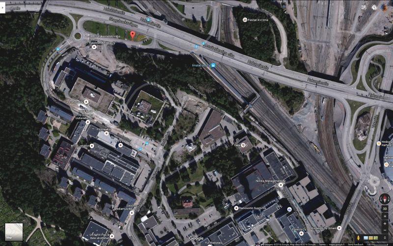
In the West-Pasila [1], easily reachable by public trafic
- - -
Länsi-Pasilassa hyvien liikenneyhteyksien varressa.
Plans
I'll try wishfully find time to visit there @ Lunchtime. / PPP
- - - -
Lounasaikaan saattaisi ehtiä jos jättää syömättä tai ahmii. / PPP
Tilley's plans: Will attempt this today, but I can only make it after work, around 18 pm. That's probably too late for you, PPP?
Participants
Expedition 2(?): Tilley
Expedition
Tilley's expedition:
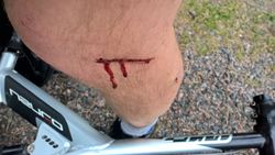
I set out after work about 17:50. On the way I couldn't resist the nice forest trails and cliffs in the Central Park of Helsinki and I circled around a bit to tackle those. And there were raptors, too, lurking in the forest, only 200 meters from the hashpoint! They ambushed me and I barely managed to escape with some wounds. See pictures for proof.
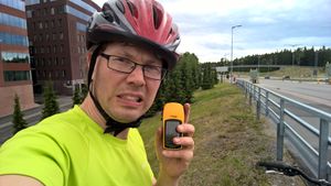
The hashpoint was found easily. It was on a steep slope of grass, built there for the purpose of the elevated road. My GPS pinpointed me to almost to the top of the slope, although Google Maps suggests that the point would have been on the bottom of the slope. Actually you can see that in my "grin of agony" -picture GPS shows 19 meters to the point, although the previous GPS close-up shot of 1 m was taken at the exactly same spot. Nevertheless, the point was definitely reached, because I climbed the slope from the bottom to the top. I took some photos and continued to my place of stay in Leppävaara to tend to my wounds.
Weather & Sky
Cloudy, windy.
Photos
Achievements
Tilley earned the Velociraptor Geohash Achievement
|
Tilley achieved level 6 of the Minesweeper Geohash achievement
|
Tilley earned the Bicycle geohash achievement
|
Tilley earned the Land geohash achievement
|


