Difference between revisions of "2018-01-08 34 32"
imported>Sourcerer m (→Photos) |
m |
||
| (17 intermediate revisions by 3 users not shown) | |||
| Line 9: | Line 9: | ||
== Location == | == Location == | ||
| − | + | Close to the Adonis Baths and waterfall, in low mountainous terrain 5 miles from the coastal resort of Coral Bay north of Paphos, Cyprus. | |
== Participants == | == Participants == | ||
| Line 17: | Line 17: | ||
== Plans == | == Plans == | ||
| − | After a nasty cold and cough, my range on Sunday was only 5 miles on the flat. Although feeling better there is some doubt if I can manage 10 miles on Monday with a significant climb too. I'll try and the route is easily aborted if necessary. My plan is to set out early to gain height in the morning cool. I can return in the heat of the day, downhill. I'll use the frequent 615 bus to get to the start - maybe the 8am bus from the harbour but I'm not certain. The terrain at the hashpoint is unknown. | + | After a nasty cold and cough, my range on Sunday was only 5 miles on the flat. Although feeling better there is some doubt if I can manage 10 miles on Monday with a significant climb too. I'll try and the route is easily aborted if necessary. My plan is to set out early to gain height in the morning cool (1200 feet or 366 metres). I can return in the heat of the day, downhill. I'll use the frequent 615 bus to get to the start - maybe the 8am bus from the harbour but I'm not certain. The terrain at the hashpoint is unknown. |
| − | == Expedition == | + | == Expedition - Fail == |
| + | My day did not start well. My man-flu congested bowels decided to clear up this morning causing a slight delay. Then I forgot my sun hat and had to return to get it. Finally I got lost on the way to the bus station on a route so simple I began to doubt my sanity. Aiming for the the 08:00, I just missed the 08:20 and finally caught the 08:30. | ||
| + | |||
| + | It was a nice day out and I got to within 150 metres of the hashpoint. Sadly there was a serious ravine requiring abseiling and machete scrub clearance. There might have been alternative approaches. OpenStreetMap thought the point was in the stream bed very close to a footpath originating at the Adonis Baths but sadly these were closed. By now I was dehydrated and really tired. My man-flu was still active. I drank 1.5 litres of water but really needed 3! The walk included just under 2000 feet uphill, hence my water underestimate. I ate a home made mayonnaise sandwich with an almost hard boiled egg. The food and water partially fixed me but I'd lost the will and energy to continue uphill. The walk back down was bearable but I was suffering. My lungs and sinuses were clearing with much coughing and snot. | ||
== Photos == | == Photos == | ||
<gallery caption="Gallery" widths="200px" heights="200px" perrow="3"> | <gallery caption="Gallery" widths="200px" heights="200px" perrow="3"> | ||
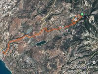
| − | Image:2018- | + | Image:2018-01-08 34 32 Sourcerer Plan.jpg | Plan |
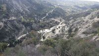
| + | Image:2018-01-08 34 32 Sourcerer HP.jpg | Adonis Baths Parking. The hashpoint is upstream from here. | ||
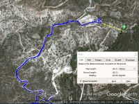
| + | Image:2018-01-08 34 32 Sourcerer Log.jpg | Google Earth Track Log | ||
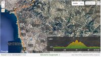
| + | Image:2018-01-08 34 32 Wikiloc.jpg | [https://www.wikiloc.com/hiking-trails/2018-01-08-34-32-21939815 Wikiloc International Walks and Tracklogs Database] | ||
</gallery> | </gallery> | ||
| Line 32: | Line 38: | ||
{{Sourcerer_links | {{Sourcerer_links | ||
| prev = 2018-01-03 39 27 | | prev = 2018-01-03 39 27 | ||
| − | | curr = 2018-01-08 | + | | curr = 2018-01-08 34 32 |
| − | | next = 2018- | + | | next = 2018-01-31 43 19 |
| − | | date = 2018-01- | + | | date = 2018-01-08 |
}} | }} | ||
| − | [[Category: | + | [[Category:Expeditions]] |
[[Category:Expeditions with photos]] | [[Category:Expeditions with photos]] | ||
| − | + | [[Category:Coordinates not reached]] | |
| + | [[Category:Not reached - Mother Nature]] | ||
| + | {{location|CY|05}} | ||
Latest revision as of 11:10, 27 March 2022
| Mon 8 Jan 2018 in Akrotiri, Cyprus: 34.8726278, 32.4385593 geohashing.info google osm bing/os kml crox |
Location
Close to the Adonis Baths and waterfall, in low mountainous terrain 5 miles from the coastal resort of Coral Bay north of Paphos, Cyprus.
Participants
Plans
After a nasty cold and cough, my range on Sunday was only 5 miles on the flat. Although feeling better there is some doubt if I can manage 10 miles on Monday with a significant climb too. I'll try and the route is easily aborted if necessary. My plan is to set out early to gain height in the morning cool (1200 feet or 366 metres). I can return in the heat of the day, downhill. I'll use the frequent 615 bus to get to the start - maybe the 8am bus from the harbour but I'm not certain. The terrain at the hashpoint is unknown.
Expedition - Fail
My day did not start well. My man-flu congested bowels decided to clear up this morning causing a slight delay. Then I forgot my sun hat and had to return to get it. Finally I got lost on the way to the bus station on a route so simple I began to doubt my sanity. Aiming for the the 08:00, I just missed the 08:20 and finally caught the 08:30.
It was a nice day out and I got to within 150 metres of the hashpoint. Sadly there was a serious ravine requiring abseiling and machete scrub clearance. There might have been alternative approaches. OpenStreetMap thought the point was in the stream bed very close to a footpath originating at the Adonis Baths but sadly these were closed. By now I was dehydrated and really tired. My man-flu was still active. I drank 1.5 litres of water but really needed 3! The walk included just under 2000 feet uphill, hence my water underestimate. I ate a home made mayonnaise sandwich with an almost hard boiled egg. The food and water partially fixed me but I'd lost the will and energy to continue uphill. The walk back down was bearable but I was suffering. My lungs and sinuses were clearing with much coughing and snot.
Photos
- Gallery
Achievements
Expeditions and Plans
| 2018-01-08 | ||
|---|---|---|
| Akrotiri, Cyprus | Sourcerer | Close to the Adonis Baths and waterfall, in low mountainous terrain 5 miles... |
Sourcerer's Expedition Links
2018-01-03 39 27 - 2018-01-08 34 32 - 2018-01-31 43 19 - KML file download of Sourcerer's expeditions for use with Google Earth.


