Difference between revisions of "2021-11-07 52 9"
From Geohashing
m (user categories) |
m (Adding hours) |
||
| Line 42: | Line 42: | ||
[[Category:Expeditions with photos]] | [[Category:Expeditions with photos]] | ||
{{location|DE|NI|HI}} | {{location|DE|NI|HI}} | ||
| − | {{user categories|user=Fippe|bike=10|train=105|foot=3}} | + | {{user categories|user=Fippe|bike=10|train=105|foot=3|hours=11}} |
Latest revision as of 19:47, 11 December 2022
| Sun 7 Nov 2021 in 52,9: 52.0569274, 9.9906196 geohashing.info google osm bing/os kml crox |
Location
This Geohash is located on a field in Bad Salzdetfurth.
Participants
Expedition
I cycled to Anderten-Misburg, took the train to to Bad Salzdetfurth via Hildesheim and walked the rest of the distance.
The Geohash was on a field on a hill surrounded by forest on three sides. I first walked around the field and then after a few steps onto the field, I reached the coordinates and recorded proof. The view of the city from up there was nice.
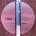
Afterwards, I walked back to the station. On the way back from the Geohash to the station, I noticed a memorial dedicated to the 10th Meridian East, which splits Bad Salzdetfurth. I had already been Geohashing on the other side six years ago, so this completes my regional geohash for this city.
Photos
Achievements
Fippe earned the Land geohash achievement
|
Fippe earned the Regional geohashing achievement
|


