Difference between revisions of "2022-11-03 58 5"
From Geohashing
(→Photos) |
|||
| (6 intermediate revisions by one other user not shown) | |||
| Line 1: | Line 1: | ||
| − | + | {{meetup graticule | |
| − | |||
| − | |||
| − | |||
| − | |||
| − | |||
| − | |||
| − | |||
| − | |||
| lat=58 | | lat=58 | ||
| lon=5 | | lon=5 | ||
| Line 20: | Line 12: | ||
--> | --> | ||
*[[User:Pica42|Pica42]] | *[[User:Pica42|Pica42]] | ||
| − | |||
| − | |||
| − | |||
== Expedition == | == Expedition == | ||
<!-- how it all turned out. your narrative goes here. --> | <!-- how it all turned out. your narrative goes here. --> | ||
| − | + | Today there was a little break between the rain showers so I had time for a Geohashing trip. There weren't many others out so I wasn't disturbed. | |
| − | |||
| − | |||
== Photos == | == Photos == | ||
| Line 35: | Line 22: | ||
--> | --> | ||
<gallery perrow="5"> | <gallery perrow="5"> | ||
| − | |||
Image:2022-11-03_58_5_Pica42_1667471937441.jpg|Re [https://openstreetmap.org/?mlat=58.72966750&mlon=5.61795540&zoom=16 @58.7297,5.6180] | Image:2022-11-03_58_5_Pica42_1667471937441.jpg|Re [https://openstreetmap.org/?mlat=58.72966750&mlon=5.61795540&zoom=16 @58.7297,5.6180] | ||
Image:20221103 58 5 01 SV.jpg|thumb|View to the southwest | Image:20221103 58 5 01 SV.jpg|thumb|View to the southwest | ||
| Line 45: | Line 31: | ||
{{#vardefine:ribbonwidth|100%}} | {{#vardefine:ribbonwidth|100%}} | ||
<!-- Add any achievement ribbons you earned below, or remove this section --> | <!-- Add any achievement ribbons you earned below, or remove this section --> | ||
| + | {{land geohash |name=[[User:Pica42|Pica42]] |date=2022-11-03 |latitude=58 |longitude=5 }} | ||
__NOTOC__ | __NOTOC__ | ||
| − | |||
| − | |||
| − | |||
| − | |||
| − | |||
| − | |||
| − | |||
| − | |||
| − | |||
| − | |||
| − | |||
| − | |||
| − | |||
| − | |||
[[Category:Expeditions]] | [[Category:Expeditions]] | ||
| − | |||
[[Category:Expeditions with photos]] | [[Category:Expeditions with photos]] | ||
| − | |||
| − | |||
| − | |||
| − | |||
| − | |||
[[Category:Coordinates reached]] | [[Category:Coordinates reached]] | ||
| − | + | {{location|NO|11}} | |
| − | |||
| − | |||
| − | |||
| − | |||
| − | |||
| − | |||
| − | |||
| − | |||
| − | |||
| − | |||
| − | |||
| − | |||
| − | |||
| − | |||
| − | |||
| − | |||
| − | |||
Latest revision as of 11:04, 5 November 2022
| Thu 3 Nov 2022 in 58,5: 58.7296160, 5.6179380 geohashing.info google osm bing/os kml crox |
Location
Grødelandsvegen, Bryne, Norway
Participants
Expedition
Today there was a little break between the rain showers so I had time for a Geohashing trip. There weren't many others out so I wasn't disturbed.
Photos
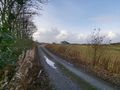
View to the southwest
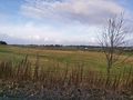
View to the northwest
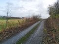
View to the northeast


Achievements
Pica42 earned the Land geohash achievement
|