Difference between revisions of "2024-09-14 53 7"
Beardygrade (talk | contribs) (→Photos) |
m (Location) |
||
| (One intermediate revision by one other user not shown) | |||
| Line 1: | Line 1: | ||
| − | + | {{meetup graticule|date=2024-09-14|lat=53|lon=7}} | |
| − | |||
| − | |||
| − | |||
| − | |||
| − | |||
| − | |||
| − | |||
| − | |||
== Location == | == Location == | ||
| − | |||
On a corn field near Wolfstange. | On a corn field near Wolfstange. | ||
== Participants == | == Participants == | ||
| − | |||
| − | |||
* [[User:Beardygrade|Beardygrade]] | * [[User:Beardygrade|Beardygrade]] | ||
== Plans == | == Plans == | ||
| − | |||
Since the distance between my home and the geohash was shown as slightly more than 18 km I planned to go there by bike and gave myself about 90 minutes, considering the road layout was not exactly the same as the proverbial crow's flight path. | Since the distance between my home and the geohash was shown as slightly more than 18 km I planned to go there by bike and gave myself about 90 minutes, considering the road layout was not exactly the same as the proverbial crow's flight path. | ||
I also set out for a Tron achievement, planning to go a different route on the way home. | I also set out for a Tron achievement, planning to go a different route on the way home. | ||
== Expedition == | == Expedition == | ||
| − | |||
Starting at roughly 14:30, I didnt make it in time to the geohash but arrived at 16:30. This was due to some bad ad hoc routing decisions and to my refusal to backtrack when I became aware of them, because I didn't want to sacrifice the Tron achievement. The first leg of the journey was dominated by using and enjoying a quite novel cycle highway. | Starting at roughly 14:30, I didnt make it in time to the geohash but arrived at 16:30. This was due to some bad ad hoc routing decisions and to my refusal to backtrack when I became aware of them, because I didn't want to sacrifice the Tron achievement. The first leg of the journey was dominated by using and enjoying a quite novel cycle highway. | ||
Shortly after, there were construction sites for a new 380 kv high voltage line. | Shortly after, there were construction sites for a new 380 kv high voltage line. | ||
| Line 32: | Line 19: | ||
== Tracklog == | == Tracklog == | ||
| − | |||
[[File:Bildschirmfoto_2024-09-14_22-51-59.png|400px]] | [[File:Bildschirmfoto_2024-09-14_22-51-59.png|400px]] | ||
| Line 38: | Line 24: | ||
== Photos == | == Photos == | ||
| − | |||
| − | |||
| − | |||
<gallery perrow="5"> | <gallery perrow="5"> | ||
| − | |||
| − | |||
Image:2024-09-14_53_7_beardygrade_1726350502615.jpg|Site of the geohash (you cannot see the corn because of the tree). | Image:2024-09-14_53_7_beardygrade_1726350502615.jpg|Site of the geohash (you cannot see the corn because of the tree). | ||
| − | |||
Image:2024-09-14_53_7_beardygrade_1726324546274.jpg|Proof [https://openstreetmap.org/?mlat=53.05136790&mlon=7.93215210&zoom=16 @53.0514,7.9322] | Image:2024-09-14_53_7_beardygrade_1726324546274.jpg|Proof [https://openstreetmap.org/?mlat=53.05136790&mlon=7.93215210&zoom=16 @53.0514,7.9322] | ||
| − | |||
Image:2024-09-14_53_7_beardygrade_1726347644526.jpg|On the site of the geohash. | Image:2024-09-14_53_7_beardygrade_1726347644526.jpg|On the site of the geohash. | ||
| − | |||
Image:2024-09-14_53_7_beardygrade_1726347714665.jpg|Installation scaffold for a new high voltage line. [https://openstreetmap.org/?mlat=53.10721111&mlon=8.08805556&zoom=16 @53.1072,8.0881] | Image:2024-09-14_53_7_beardygrade_1726347714665.jpg|Installation scaffold for a new high voltage line. [https://openstreetmap.org/?mlat=53.10721111&mlon=8.08805556&zoom=16 @53.1072,8.0881] | ||
| − | |||
Image:2024-09-14_53_7_beardygrade_1726347770348.jpg|Something is missing here. [https://openstreetmap.org/?mlat=53.09722222&mlon=8.09335000&zoom=16 @53.0972,8.0934] | Image:2024-09-14_53_7_beardygrade_1726347770348.jpg|Something is missing here. [https://openstreetmap.org/?mlat=53.09722222&mlon=8.09335000&zoom=16 @53.0972,8.0934] | ||
| − | |||
</gallery> | </gallery> | ||
== Achievements == | == Achievements == | ||
{{#vardefine:ribbonwidth|100%}} | {{#vardefine:ribbonwidth|100%}} | ||
| − | |||
| − | |||
| − | |||
| − | |||
| − | |||
| − | |||
| − | |||
| − | |||
| − | |||
| − | |||
| − | |||
| − | |||
| − | |||
| − | |||
| − | |||
| − | |||
| − | |||
| − | |||
| − | |||
| − | |||
| − | |||
| − | |||
| − | |||
| − | |||
| − | |||
| − | |||
| − | |||
| − | |||
| − | |||
| − | |||
| − | |||
| − | |||
| − | |||
| − | |||
| − | |||
{{bicycle geohash|date=2024-09-14|latitude=53|longitude=7|name=[[User:Beardygrade|Beardygrade]]|distance=|bothways=|image=}} | {{bicycle geohash|date=2024-09-14|latitude=53|longitude=7|name=[[User:Beardygrade|Beardygrade]]|distance=|bothways=|image=}} | ||
| Line 105: | Line 46: | ||
| possessive = his | | possessive = his | ||
}} | }} | ||
| + | |||
| + | __NOTOC__ | ||
| + | [[Category:Expeditions]] | ||
| + | [[Category:Expeditions with photos]] | ||
| + | [[Category:Coordinates reached]] | ||
| + | {{location|DE|NI|CLP}} | ||
Latest revision as of 20:45, 23 September 2024
| Sat 14 Sep 2024 in 53,7: 53.0513396, 7.9321299 geohashing.info google osm bing/os kml crox |
Location
On a corn field near Wolfstange.
Participants
Plans
Since the distance between my home and the geohash was shown as slightly more than 18 km I planned to go there by bike and gave myself about 90 minutes, considering the road layout was not exactly the same as the proverbial crow's flight path. I also set out for a Tron achievement, planning to go a different route on the way home.
Expedition
Starting at roughly 14:30, I didnt make it in time to the geohash but arrived at 16:30. This was due to some bad ad hoc routing decisions and to my refusal to backtrack when I became aware of them, because I didn't want to sacrifice the Tron achievement. The first leg of the journey was dominated by using and enjoying a quite novel cycle highway. Shortly after, there were construction sites for a new 380 kv high voltage line.
Because there was no convenient road leading in the precise direction of the geohash, I started zig-zagging on ever smaller and more gravelly roads, losing time and obviously my sense of orientation. Short of entering Oldenburg again, I was able to correct the course and subsequently crossed the coastal canal. The next few kilometers were along the canal, then I had to go southward and entered the county Cloppenburg. After crossing the small river Lahe I was able to approach the geohash which was located roghly 5 m into a corn field. I had dismount in order to cross a blackberry barrier and a ditch to enter the field. In order to maintain the Tron achievement, I left the field crossing another ditch and carefully approached my bike from the front. I had to backtrack for some 50 m but luckily the road has a grassy zone in the middle so it is save to claim I used opposite lanes.
I then added some more kilometers in order to avoid crossing my path and on a road crossing I met a very nice guy who climbed a roadside apple tree and gave me a delicious apple. After some more zig-zagging I could cross the coastal canal again. In Oldenburg I approached my house from the opposite end of the road.
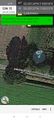
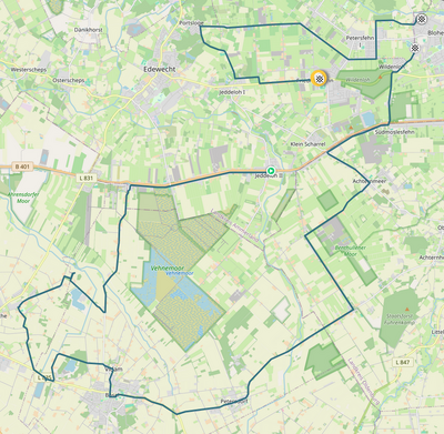
Tracklog

There are gaps in the track when my phone couldn't get a satellite fix. In the direct vicinity of the geohash I had to use the same path in both directions but I painstakingly avoided crossing my own path.
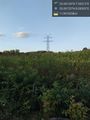
Photos
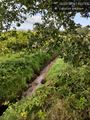
Site of the geohash (you cannot see the corn because of the tree).
Proof @53.0514,7.9322
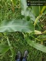
On the site of the geohash.
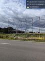
Installation scaffold for a new high voltage line. @53.1072,8.0881
Something is missing here. @53.0972,8.0934


Achievements
Beardygrade earned the Bicycle geohash achievement
|
Beardygrade earned the Land geohash achievement
|
Beardygrade earned the Tron achievement
|