Difference between revisions of "2024-09-23 48 11"
From Geohashing
(Created page with "{{meetup graticule | lat=48 | lon=11 | date=2024-09-23 }} == Location == On a small hill in Vierkirchen == Participants == *[[User:Iqui|Iqui]...") |
m (Location correction) |
||
| (5 intermediate revisions by one other user not shown) | |||
| Line 5: | Line 5: | ||
}} | }} | ||
== Location == | == Location == | ||
| − | On a small hill in [[wikipedia:Vierkirchen|Vierkirchen]] | + | On top of a small hill in [[wikipedia:Vierkirchen|Vierkirchen]] |
== Participants == | == Participants == | ||
| Line 11: | Line 11: | ||
== Expedition == | == Expedition == | ||
| − | *[[User:Iqui|Iqui]]: | + | *[[User:Iqui|Iqui]]: I only had about one and a half hours to get this hash, but due to my new phone holder finding my way there was no problem. The ride was amazing, and I decided to take a different way back home. |
== Photos == | == Photos == | ||
<gallery mode="packed" heights="200px"> | <gallery mode="packed" heights="200px"> | ||
| − | + | File:2024-09-23 48 11 me at location.jpeg | me at location | |
| + | File:2024-09-23 48 11 proof 2.png | proof 2 | ||
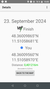
| + | File:2024-09-23 48 11 proof 1.png | proof 1 | ||
| + | File:2024-09-23 48 11 distance.jpeg | distance | ||
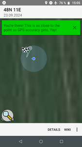
| + | File:2024-09-23 48 11 location.jpeg | location | ||
</gallery> | </gallery> | ||
== Tracklog == | == Tracklog == | ||
| − | {{tracklog | 2024-09- | + | {{tracklog | 2024-09-23 48 11 tracklog.gpx }} |
== Achievements == | == Achievements == | ||
{{#vardefine:ribbonwidth|100%}} | {{#vardefine:ribbonwidth|100%}} | ||
{{land geohash | latitude = 48 | longitude = 11 | date = 2024-09-23 | name = [[User:Iqui|Iqui]] | image = 2024-09-01 48 11 location from street.jpeg }} | {{land geohash | latitude = 48 | longitude = 11 | date = 2024-09-23 | name = [[User:Iqui|Iqui]] | image = 2024-09-01 48 11 location from street.jpeg }} | ||
| − | {{Bicycle geohash | latitude = 48 | longitude = 11 | date = 2024-09-23 | name = [[User:Iqui|Iqui]] | distance = 27,45 km | bothways = true | image = | + | {{Bicycle geohash | latitude = 48 | longitude = 11 | date = 2024-09-23 | name = [[User:Iqui|Iqui]] | distance = 27,45 km | bothways = true | image = 2024-09-23 48 11 me at location.jpeg }} |
__NOTOC__ | __NOTOC__ | ||
| Line 30: | Line 34: | ||
[[Category:Expeditions with photos]] | [[Category:Expeditions with photos]] | ||
[[Category:Coordinates reached]] | [[Category:Coordinates reached]] | ||
| − | {{location|DE|BY| | + | {{location|DE|BY|DAH}} |
Latest revision as of 03:52, 24 September 2024
| Mon 23 Sep 2024 in 48,11: 48.3600987, 11.5105868 geohashing.info google osm bing/os kml crox |
Location
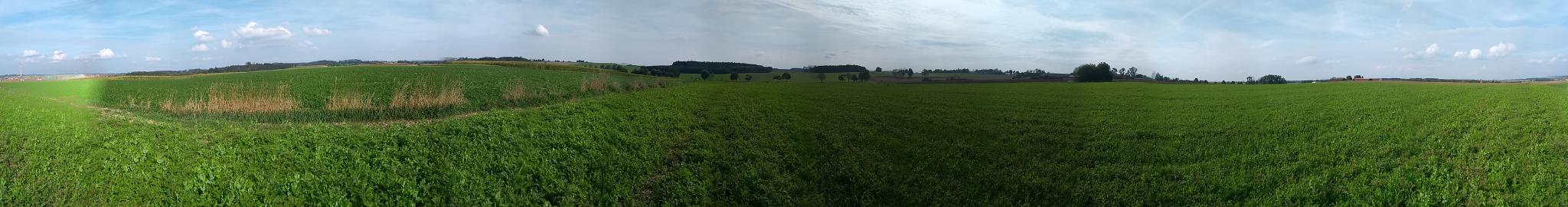
On top of a small hill in Vierkirchen
Participants
Expedition
- Iqui: I only had about one and a half hours to get this hash, but due to my new phone holder finding my way there was no problem. The ride was amazing, and I decided to take a different way back home.
Photos

me at location
proof 2
proof 1
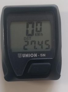
distance
location


Tracklog
Achievements
Iqui earned the Land geohash achievement
|
Iqui earned the Bicycle geohash achievement
|