Difference between revisions of "2009-07-28 49 -122"
From Geohashing
imported>Rhonda (→Expedition: +subsections) |
imported>MykaDragonBlue (there's photos) |
||
| Line 48: | Line 48: | ||
[[Category:Expeditions]] | [[Category:Expeditions]] | ||
[[Category:Coordinates reached]] | [[Category:Coordinates reached]] | ||
| + | [[Category:Expeditions with photos]] | ||
Revision as of 21:39, 29 July 2009
| Tue 28 Jul 2009 in Delta: 49.1648351, -122.9660527 geohashing.info google osm bing/os kml crox |
Contents
Location
Possibly a store front on Annacis Island in Delta
Participants
Plans
After work
- Meet at 22nd Street skytrain at 5:25pm
- Catch the 104 bus at bay 5, ~5:31pm (runs every 12 minutes) Map Timetable
- Reach the hashpoint
- Catch the bus back
Expedition
In progress.
Rhonda
Xore
PhilB
At the hash point
Photos
We arrived
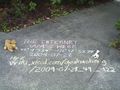
and marked the spot;

PhilB

Rhonda

and xore.


