Difference between revisions of "2010-07-08 59 11"
From Geohashing
imported>Eiggen |
imported>Eiggen |
||
| Line 24: | Line 24: | ||
* [[User:Eiggen|eiggen]] | * [[User:Eiggen|eiggen]] | ||
| − | ==Expedition == | + | == Expedition == |
| − | [[Category: | + | == Photos == |
| + | |||
| + | |||
| + | <!-- =============== USEFUL CATEGORIES FOLLOW ================ | ||
| + | Delete the next line ONLY if you have chosen the appropriate categories below. If you are unsure, don't worry. People will read your report and help you with the classification. --> | ||
| + | [[Category:New report]] | ||
| + | |||
| + | [[Category:Coordinates reached]] | ||
| + | [[Category:Expeditions]] | ||
| + | [[Category:Expeditions with photos]] | ||
Revision as of 18:27, 8 July 2010
| Thu 8 Jul 2010 in Sarpsborg: 59.9757611, 11.1099371 geohashing.info google osm bing/os kml crox |
Contents
Location
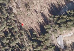
Destination is in a field right by the end of Flaenveien, in the area of Skedsmo, East of Oslo, which should be legally accessible for the public.
Plans
Closest public transportation is Leirsund train station, and the plan is to run from there and back, around 3 km following roads. I will drag along a friend, and the preliminary schedule starts at Oslo S just before five pm, arriving at the destination some time after half past five, all local time.
