Difference between revisions of "2011-08-04 48 10"
From Geohashing
imported>Ordnungswidrig (→Location) |
imported>Ordnungswidrig (→Achievements) |
||
| Line 51: | Line 51: | ||
{{#vardefine:ribbonwidth|800px}} | {{#vardefine:ribbonwidth|800px}} | ||
<!-- Add any achievement ribbons you earned below, or remove this section --> | <!-- Add any achievement ribbons you earned below, or remove this section --> | ||
| + | {{land geohash | ||
| − | + | | latitude = 48.4789 | |
| + | | longitude = 10.006 | ||
| + | | date = 2011-08-04 | ||
| + | | name = ordnungswidrig | ||
| + | |||
| + | }} | ||
<!-- =============== USEFUL CATEGORIES FOLLOW ================ | <!-- =============== USEFUL CATEGORIES FOLLOW ================ | ||
Revision as of 07:51, 5 August 2011
| Thu 4 Aug 2011 in 48,10: 48.4789413, 10.0065033 geohashing.info google osm bing/os kml crox |
Location
Hayfield near Hörvelsingen
Participants
- Ordnungswidrig - first hash
Plans
Unknown
Expedition
Looks like someone made it there, based on the coords on the picture.
Parked near the location next to the forest. 5 min footwalk on the hayfield. Biggest obstacle was the loss of cell phone connection. No other hash met.
Tracklog
Photos
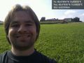
Lonely in the sunshine... @48,4789,10,0065

Achievements
ordnungswidrig earned the Land geohash achievement
|